The Blue Marble, a photograph of the planet Earth made on 7 December 1972 by the crew of the Apollo 17 spacecraft.
The world is the totality of entities, the whole of reality, or everything that exists. The nature of the world has been conceptualized differently in different fields. Some conceptions see the world as unique while others talk of a "plurality of worlds". Some treat the world as one simple object while others analyze the world as a complex made up of parts.
In scientific cosmology, the world or universe is commonly defined as "[t]he totality of all space and time; all that is, has been, and will be". Theories of modality talk of possible worlds as complete and consistent ways how things could have been. Phenomenology, starting from the horizon of co-given objects present in the periphery of every experience, defines the world as the biggest horizon or the "horizon of all horizons". In philosophy of mind, the world is contrasted with the mind as that which is represented by the mind. Theology conceptualizes the world in relation to God, for example, as God's creation, as identical to God or as the two being interdependent. In religions, there is a tendency to downgrade the material or sensory world in favor of a spiritual world to be sought through religious practice. A comprehensive representation of the world and our place in it, as is found in religions, is known as a worldview. Cosmogony is the field that studies the origin or creation of the world while eschatology refers to the science or doctrine of the last things or of the end of the world.
The convention's main objective is explained in Article 2. It is the "stabilization of greenhouse gas concentrations in the atmosphere at a level that would prevent dangerous anthropogenic [i.e., human-caused] interference with the climate system". The treaty calls for continuing scientific research into the climate. This research supports meetings and negotiations to lead to agreements. The aim is to allow ecosystems to adapt to climate change. At the same time it aims to ensure there are no threats to food production from climate change or measures to address it. And it aims to enable economic development to proceed in a sustainable manner. (Full article...)
Many of the technological and architectural innovations were of British origin. By the mid-18th century, Britain was the world's leading commercial nation, controlling a global trading empire with colonies in North America and the Caribbean. Britain had major military and political hegemony on the Indian subcontinent; particularly with the proto-industrialisedMughal Bengal, through the activities of the East India Company. The development of trade and the rise of business were among the major causes of the Industrial Revolution. Developments in law also facilitated the revolution, such as courts ruling in favour of property rights. An entrepreneurial spirit and consumer revolution helped drive industrialisation in Britain, which after 1800, was emulated in Belgium, the United States, and France. (Full article...)
Image 3
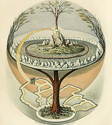
Yggdrasil, a modern attempt to reconstruct the Norse world tree which connects the heavens, the earth and the underworld The underworld, also known as the netherworld or hell, is the supernatural world of the dead in various religious traditions and myths, located below the world of the living. Chthonic is the technical adjective for things of the underworld.
The concept of an underworld is found in almost every civilization and "may be as old as humanity itself". Common features of underworld myths are accounts of living people making journeys to the underworld, often for some heroic purpose. Other myths reinforce traditions that the entrance of souls to the underworld requires a proper observation of ceremony, such as the ancient Greek story of the recently dead Patroclus haunting Achilles until his body could be properly buried for this purpose. People with high social status were dressed and equipped in order to better navigate the underworld. (Full article...)
Image 4
Poster advertising the Brussels International Exposition in 1897 A world's fair, also known as a universal exhibition or an expo, is a large global exhibition designed to showcase the achievements of nations. These exhibitions vary in character and are held in different parts of the world at a specific site for a period of time, typically between three and six months.
The term "world's fair" is commonly used in the United States, while the French term, Exposition universelle ("universal exhibition") is used in most of Europe and Asia; other terms include World Expo or Specialised Expo, with the word expo used for various types of exhibitions since at least 1958. (Full article...)
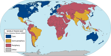
A world map of countries by their supposed trading status in 2000, using the world system differentiation into core countries (blue), semi-periphery countries (yellow) and periphery countries (red). Based on the list in Chase-Dunn, Kawana, and Brewer (2000). World-systems theory (also known as world-systems analysis or the world-systems perspective) is a multidisciplinary approach to world history and social change which emphasizes the world-system (and not nation states) as the primary (but not exclusive) unit of social analysis. World-systems theorists argue that their theory explains the rise and fall of states, income inequality, social unrest, and imperialism.
"World-system" refers to the inter-regional and transnational division of labor, which divides the world into core countries, semi-periphery countries, and periphery countries. Core countries have higher-skill, capital-intensive industries, and the rest of the world has low-skill, labor-intensive industries and extraction of raw materials. This constantly reinforces the dominance of the core countries. This structure is unified by the division of labour. It is a world-economy rooted in a capitalist economy. For a time, certain countries have become the world hegemon; during the last few centuries, as the world-system has extended geographically and intensified economically, this status has passed from the Netherlands, to the United Kingdom and (most recently) to the United States. (Full article...)
The exploration also created colonial empires and marked an increased adoption of colonialism as a government policy in several European states. As such, it is sometimes synonymous with the first wave of European colonization. The colonization reshaped power dynamics causing geopolitical shifts in Europe and creating new centers of power beyond Europe. Having set human history on the global common course, the legacy of the Age still shapes the world today. (Full article...)
Image 3Tiktaalik, a fish with limb-like fins and a predecessor of tetrapods. Reconstruction from fossils about 375 million years old. (from History of Earth)
Image 4First airplane, the Wright Flyer, flew on 17 December 1903.
Image 5An artist's impression of the Archean, the eon after Earth's formation, featuring round stromatolites, which are early oxygen-producing forms of life from billions of years ago. After the Late Heavy Bombardment, Earth's crust had cooled, its water-rich barren surface is marked by continents and volcanoes, with the Moon still orbiting Earth half as far as it is today, appearing 2.8 times larger and producing strong tides. (from Earth)
Image 8Earth's night-side upper atmosphere appearing from the bottom as bands of afterglow illuminating the troposphere in orange with silhouettes of clouds, and the stratosphere in white and blue. Next the mesosphere (pink area) extends to the orange and faintly green line of the lowest airglow, at about one hundred kilometers at the edge of space and the lower edge of the thermosphere (invisible). Continuing with green and red bands of aurorae stretching over several hundred kilometers. (from Earth)
Image 10A view of Earth with its global ocean and cloud cover, which dominate Earth's surface and hydrosphere; at Earth's polar regions, its hydrosphere forms larger areas of ice cover. (from Earth)
Image 12Change in average surface air temperature and drivers for that change. Human activity has caused increased temperatures, with natural forces adding some variability. (from Earth)
Image 16A 2012 artistic impression of the early Solar System's protoplanetary disk from which Earth and other Solar System bodies were formed (from Earth)
Image 19The replicator in virtually all known life is deoxyribonucleic acid. DNA is far more complex than the original replicator and its replication systems are highly elaborate. (from History of Earth)
Image 23An animation of the changing density of productive vegetation on land (low in brown; heavy in dark green) and phytoplankton at the ocean surface (low in purple; high in yellow) (from Earth)
Image 24Earth's axial tilt causing different angles of seasonal illumination at different orbital positions around the Sun (from Earth)
Image 27Pangaea was a supercontinent that existed from about 300 to 180 Ma. The outlines of the modern continents and other landmasses are indicated on this map. (from History of Earth)
Image 32A map of heat flow from Earth's interior to the surface of Earth's crust, mostly along the oceanic ridges (from Earth)
Image 33Earth's western hemisphere showing topography relative to Earth's center instead of to mean sea level, as in common topographic maps (from Earth)
Image 38A schematic view of Earth's magnetosphere with solar wind flowing from left to right (from Earth)
Image 39Artist's rendition of an oxinated fully-frozen Snowball Earth with no remaining liquid surface water. (from History of Earth)
Image 40Artist's impression of Earth during the later Archean, the largely cooled planetary crust and water-rich barren surface, marked by volcanoes and continents, features already roundmicrobialites. The Moon, still orbiting Earth much closer than today and still dominating Earth's sky, produced strong tides. (from History of Earth)
Image 43An artist's impression of ice age Earth at glacial maximum. (from History of Earth)
Image 44Artist's impression of a Hadean landscape with the relatively newly formed Moon still looming closely over Earth and both bodies sustaining strong volcanism. (from History of Earth)
Image 46Trilobites first appeared during the Cambrian period and were among the most widespread and diverse groups of Paleozoic organisms. (from History of Earth)
Image 47A reconstruction of human history based on fossil data. (from History of Earth)
Image 62Exaggerated illustration of Earth's elliptical orbit around the Sun, marking that the orbital extreme points (apoapsis and periapsis) are not the same as the four seasonal extreme points, the equinox and solstice (from Earth)
Image 63Geologic map of North America, color-coded by age. From most recent to oldest, age is indicated by yellow, green, blue, and red. The reds and pinks indicate rock from the Archean.
In the classical antiquity, part of the territory of present-day Tehran was occupied by Rhages (now Ray), a prominent Median city destroyed in the medieval Arab, Turkic, and Mongol invasions. Modern Ray was absorbed into the metropolitan area of Greater Tehran. (Full article...)
... that in the 1916 Declaration of Sainte-Adresse Britain, France and Russia committed to securing the political and economic independence of Belgium after the First World War?
... that after bombing in World War II, the surviving tower of the Friedenskirche, a Lutheran church in Stuttgart, was combined with a new concrete structure?
Various lists of the Seven Wonders of Romania (Romanian: Cele Șapte Minuni ale României) have been compiled from past to the present day, to catalogue Romania's most spectacular artificial structures. (Full article...)
About 5.18% of the area of Romania has a protected status (12,360 km2), including the Danube Delta, which makes half of these areas (2.43% of Romania's area). (Full article...)
Strict nature reserve — Area of unmodified natural features with representative ecosystems set aside for the preservation of its biodiversity and for scientific research and monitoring.
Special nature reserve — Area of unmodified or slightly modified natural features of great importance due to uniqueness and rarity which includes the habitats of endangered species set aside for the preservation of its unique features, education, limited tourism and for scientific research and monitoring.
National park — Area with large number of diverse ecosystems of national value, with outstanding natural features and/or cultural heritage set aside for the preservation of its natural resources and for educational, scientific and tourist use.
Natural monument — Small unmodified or slightly modified natural feature, object or phenomenon, easily detectable and unique, with unique natural attributes.
Protected habitat — Area which includes habitats of one or more wildlife species.
Landscape of outstanding features — Area of remarkable appearance with important natural and cultural value.
Nature park — Area of well-preserved natural values with preserved natural ecosystems and picturesque landscape set aside for the preservation of biodiversity and for educational, tourist, recreational and scientific use.
Estonia has five national parks, 167 nature reserves and 152 landscape conservation areas. In addition, there are 116 (118) protected areas with an old (Soviet-era) protection regulation and 537 parks. In total, 18.1% of Estonia are protected nature areas, with Lääne County having the highest percentage (32%) and Põlva County the lowest percentage of protected areas, about 9%. (Full article...)
Image 6
As of present, there are around 400 protected areas in Pakistan that are recognized by IUCN. The total protected land area represents 13% of Pakistan's landmass as of 2020, The Government of Pakistan plans to increase it to at least 15% by 2023. As a signatory of the UN Convention on Biological Diversity, Pakistan is committed to expanding its protected areas to encompass 17% of its total territory by the year 2030. This ambitious goal aims to ensure the long-term conservation of nature, safeguard vital ecosystem services, and preserve the cultural values associated with these protected areas. (Full article...)
Image 7
The protected areas of Michigan come in an array of different types and levels of protection. Michigan has five units of the National Park Service system. There are 14 federal wilderness areas; the majority of these are also tribal-designated wildernesses. It has one of the largest state forest systems as well having four national forests. The state maintains a large state park system and there are also regional parks, and county, township and city parks. Still other parks on land and in the Great Lakes are maintained by other governmental bodies. Private protected areas also exist in the state, mainly lands owned by land conservancies. (Full article...)
The state of Johor in Malaysia is noted for its national parks and forest reserves which preserve virgin rainforests known for its biodiversity and endangered species of animals. Mangrove swamps and coral reefs are also protected within these parks. (Full article...)
Image 11
Andohahela National Park in southern Madagascar The national parks of Madagascar include all officially recognized protected areas as of 2015. The protected areas network of Madagascar is managed by the Madagascar National Parks Association (PNM-ANGAP). The network includes three types of protected areas: Strict Nature Reserves (IUCN category Ia), National Parks (IUCN category II) and Wildlife Reserves (IUCN category IV). At the 2003 IUCN World Parks Congress in Durban, the Malagasy President, Marc Ravalomanana, announced an initiative to more than triple the area under protection from approximately 17,000 km2 (6,600 sq mi) to over 60,000 km2 (23,000 sq mi) (from 3% to 10% of Madagascar's area). This "Durban Vision", as it has been dubbed, involved broadening the definition of protected areas in the country and legislation has been passed to allow the creation of four new categories of protected area: Natural Parks (IUCN category II), Natural Monuments (IUCN category III), Protected Landscapes (IUCN category V), and Natural Resource Reserves (IUCN category VI). As well as allowing these new objectives for protected areas management, the new legislation also provided for entities other than PNM-ANGAP to manage protected areas, such as government ministries, community associations, NGOs and other civil society organizations, and the private sector. (Full article...)
Image 12
Protected areas of Slovenia include one national park (Slovene: narodni park), three regional parks (regijski park), several natural parks (krajinski park), and hundreds of natural monuments (naravni spomenik) and monuments of designed nature (spomenik oblikovane narave). They cover about 12.5% of the Slovenian territory. Under the Wild Birds Directive, 26 sites totalling roughly 25% of the nation's land are "Special Protected Areas"; the Natura 2000 proposal would increase the totals to 260 sites and 32% of national territory. (Full article...)
Image 2Only a few of the largest large igneous provinces appear (coloured dark purple) on this geological map, which depicts crustal geologic provinces as seen in seismic refraction data


![Image 1 The United Nations Framework Convention on Climate Change (UNFCCC) is the UN process for negotiating an agreement to limit dangerous climate change. It is an international treaty among countries to combat "dangerous human interference with the climate system". The main way to do this is limiting the increase in greenhouse gases in the atmosphere. It was signed in 1992 by 154 states at the United Nations Conference on Environment and Development (UNCED), informally known as the Earth Summit, held in Rio de Janeiro. The treaty entered into force on 21 March 1994. "UNFCCC" is also the name of the Secretariat charged with supporting the operation of the convention, with offices on the UN Campus in Bonn, Germany. The convention's main objective is explained in Article 2. It is the "stabilization of greenhouse gas concentrations in the atmosphere at a level that would prevent dangerous anthropogenic [i.e., human-caused] interference with the climate system". The treaty calls for continuing scientific research into the climate. This research supports meetings and negotiations to lead to agreements. The aim is to allow ecosystems to adapt to climate change. At the same time it aims to ensure there are no threats to food production from climate change or measures to address it. And it aims to enable economic development to proceed in a sustainable manner. (Full article...)](https://upload.wikimedia.org/wikipedia/en/d/d2/Blank.png)


![Image 1 The United Nations Framework Convention on Climate Change (UNFCCC) is the UN process for negotiating an agreement to limit dangerous climate change. It is an international treaty among countries to combat "dangerous human interference with the climate system". The main way to do this is limiting the increase in greenhouse gases in the atmosphere. It was signed in 1992 by 154 states at the United Nations Conference on Environment and Development (UNCED), informally known as the Earth Summit, held in Rio de Janeiro. The treaty entered into force on 21 March 1994. "UNFCCC" is also the name of the Secretariat charged with supporting the operation of the convention, with offices on the UN Campus in Bonn, Germany. The convention's main objective is explained in Article 2. It is the "stabilization of greenhouse gas concentrations in the atmosphere at a level that would prevent dangerous anthropogenic [i.e., human-caused] interference with the climate system". The treaty calls for continuing scientific research into the climate. This research supports meetings and negotiations to lead to agreements. The aim is to allow ecosystems to adapt to climate change. At the same time it aims to ensure there are no threats to food production from climate change or measures to address it. And it aims to enable economic development to proceed in a sustainable manner. (Full article...)](https://naturehabitats.org/knowledge-base/violet-green-swallow/?rdp_we_resource=https%3A%2F%2Fen.wikipedia.org%2Fwiki%2FFile%3ABlank.png)


 Notre-Dame de Paris, France
 A computer-generated image mapping the prevalence of artificial satellites and space debris around Earth in geosynchronous and low Earth orbit (from Earth)
 Tiktaalik, a fish with limb-like fins and a predecessor of tetrapods. Reconstruction from fossils about 375 million years old. (from History of Earth)
 First airplane, the Wright Flyer, flew on 17 December 1903.
 An artist's impression of the Archean, the eon after Earth's formation, featuring round stromatolites, which are early oxygen-producing forms of life from billions of years ago. After the Late Heavy Bombardment, Earth's crust had cooled, its water-rich barren surface is marked by continents and volcanoes, with the Moon still orbiting Earth half as far as it is today, appearing 2.8 times larger and producing strong tides. (from Earth)
 Machu Picchu, Inca Empire, Peru
 Earth's night-side upper atmosphere appearing from the bottom as bands of afterglow illuminating the troposphere in orange with silhouettes of clouds, and the stratosphere in white and blue. Next the mesosphere (pink area) extends to the orange and faintly green line of the lowest airglow, at about one hundred kilometers at the edge of space and the lower edge of the thermosphere (invisible). Continuing with green and red bands of aurorae stretching over several hundred kilometers. (from Earth)
 Artist's conception of Devonian flora (from History of Earth)
 A view of Earth with its global ocean and cloud cover, which dominate Earth's surface and hydrosphere; at Earth's polar regions, its hydrosphere forms larger areas of ice cover. (from Earth)
 Chennakesava Temple, Belur, India
 Change in average surface air temperature and drivers for that change. Human activity has caused increased temperatures, with natural forces adding some variability. (from Earth)
 Taj Mahal, Mughal Empire, India
 Dinosaurs were the dominant terrestrial vertebrates throughout most of the Mesozoic (from History of Earth)
 A 2012 artistic impression of the early Solar System's protoplanetary disk from which Earth and other Solar System bodies were formed (from Earth)
 Peopling of the world, the Southern Dispersal scenario
 The replicator in virtually all known life is deoxyribonucleic acid. DNA is far more complex than the original replicator and its replication systems are highly elaborate. (from History of Earth)
 Obelisk of Axum, Ethiopia
 "Lucy", the first Australopithecus afarensis skeleton found, was only 1.06 m (3 ft 6 in) tall.
 An animation of the changing density of productive vegetation on land (low in brown; heavy in dark green) and phytoplankton at the ocean surface (low in purple; high in yellow) (from Earth)
 Earth's axial tilt causing different angles of seasonal illumination at different orbital positions around the Sun (from Earth)
 Great Mosque of Kairouan, Tunisia, founded 670 CE
 Lithified stromatolites on the shores of Lake Thetis, Western Australia. Archean stromatolites are the first direct fossil traces of life on Earth. (from History of Earth)
 Pangaea was a supercontinent that existed from about 300 to 180 Ma. The outlines of the modern continents and other landmasses are indicated on this map. (from History of Earth)
 Cross-section through a liposome (from History of Earth)
 Artist's impression of the enormous collision that probably formed the Moon (from History of Earth)
 A map of heat flow from Earth's interior to the surface of Earth's crust, mostly along the oceanic ridges (from Earth)
 Earth's western hemisphere showing topography relative to Earth's center instead of to mean sea level, as in common topographic maps (from Earth)

 Olmec colossal head, now at the Museo de Antropología de Xalapa
 Pale orange dot, an artist's impression of Early Earth, featuring its tinted orange methane-rich early atmosphere (from Earth)
 A schematic view of Earth's magnetosphere with solar wind flowing from left to right (from Earth)
 Artist's rendition of an oxinated fully-frozen Snowball Earth with no remaining liquid surface water. (from History of Earth)
 View of Earth from the Moon by the Lunar Reconnaissance Orbiter (from Earth)
 An artist's impression of ice age Earth at glacial maximum. (from History of Earth)
 Artist's impression of a Hadean landscape with the relatively newly formed Moon still looming closely over Earth and both bodies sustaining strong volcanism. (from History of Earth)
 Trilobites first appeared during the Cambrian period and were among the most widespread and diverse groups of Paleozoic organisms. (from History of Earth)
 A reconstruction of human history based on fossil data. (from History of Earth)
 A composite image of artificial light emissions at night on a map of Earth (from Earth)
 Tracy Caldwell Dyson, a NASA astronaut, observing Earth from the Cupola module at the International Space Station on 11 September 2010 (from Earth)
 Earth's history with time-spans of the eons to scale (from History of Earth)
 Yggdrasil, an attempt to reconstruct the Norse world tree which connects the heavens, the world, and the underworld. (from World)
 Image of the physical world, captured by the Hubble Space Telescope (from World)
 Chloroplasts in the cells of a moss (from History of Earth)
 Ajloun Castle, Jordan
 A reconstruction of Pannotia (550 Ma). (from History of Earth)
 Earth's land use for human agriculture in 2019 (from Earth)
 Battle during the 1281 Mongol invasion of Japan
 Benin Bronze head from Nigeria
 Shanghai. China urbanized rapidly in the 21st century.
 A composite image of Earth, with its different types of surface discernible: Earth's surface dominating Ocean (blue), Africa with lush (green) to dry (brown) land and Earth's polar ice in the form of Antarctic sea ice (grey) covering the Antarctic or Southern Ocean and the Antarctic ice sheet (white) covering Antarctica. (from Earth)

 Geologic map of North America, color-coded by age. From most recent to oldest, age is indicated by yellow, green, blue, and red. The reds and pinks indicate rock from the Archean.
 Great Pyramids of Giza, Egypt
 Satellite time lapse imagery of Earth's rotation showing axis tilt (from Earth)
 Persepolis, Achaemenid Empire, 6th century BCE
 Last Moon landing: Apollo 17 (1972)
 Empires of the world in 1898
 Vitruvian Man by Leonardo da Vinci epitomizes the advances in art and science seen during the Renaissance. (from History of Earth)
 A banded iron formation from the 3.15 Ga Moodies Group, Barberton Greenstone Belt, South Africa. Red layers represent the times when oxygen was available; gray layers were formed in anoxic circumstances. (from History of Earth)
 Florence, birthplace of the Italian Renaissance
 Angkor Wat temple complex, Cambodia, early 12th century
 Artist's conception of Hadean Eon Earth, when it was much hotter and inhospitable to all forms of life. (from History of Earth)
 A 580 million year old fossil of Spriggina floundensi, an animal from the Ediacaran period. Such life forms could have been ancestors to the many new forms that originated in the Cambrian Explosion. (from History of Earth)
 Graph showing range of estimated partial pressure of atmospheric oxygen through geologic time (from History of Earth)
 A pillar at Göbekli Tepe
 Fall of the Berlin Wall, 1989
 Standing Buddha from Gandhara, 2nd century CE
 Japanese depiction of a Portuguese carrack. European maritime innovations led to proto-globalization.
 Ming dynasty section, Great Wall of China
 An artist's rendering of a protoplanetary disk (from History of Earth)
 A view of Earth with different layers of its atmosphere visible: the troposphere with its clouds casting shadows, a band of stratospheric blue sky at the horizon, and a line of green airglow of the lower thermosphere around an altitude of 100 km, at the edge of space (from Earth)


 The Goode homolosine projection is a pseudocylindrical, equal-area, composite map projection used for world maps.
 Only a few of the largest large igneous provinces appear (coloured dark purple) on this geological map, which depicts crustal geologic provinces as seen in seismic refraction data
 Mollweide projection of the world
 The world map by Gerardus Mercator (1569), the first map in the well-known Mercator projection
 A plate tectonics map with volcano locations indicated with red circles
 Index map from the International Map of the World (1:1,000,000 scale)
 1516 map of the world by Martin Waldseemüller
 United Nations Human Development Index map by country (2016)
 Time zones of the world


 Commons
 Wikibooks
 Wikidata
 Wikinews
 Wikiquote
 Wikisource
 Wikispecies
 Wikiversity
 Wikivoyage
 Wiktionary


Recent Comments