
The New Guinea Portal
Introduction

New Guinea (Tok Pisin: Niugini; Hiri Motu: Niu Gini; Indonesian: Papua, fossilized Nugini, or historically Irian) is the world's second-largest island, with an area of 785,753 km2 (303,381 sq mi). Located in Melanesia in the southwestern Pacific Ocean, the island is separated from Australia by the 150-kilometre (81-nautical-mile; 93-mile) wide Torres Strait, though both landmasses lie on the same continental shelf, and were united during episodes of low sea level in the Pleistocene glaciations as the combined landmass of Sahul. Numerous smaller islands are located to the west and east. The island's name was given by Spanish explorer Yñigo Ortiz de Retez during his maritime expedition of 1545 due to the resemblance of the indigenous peoples of the island to those in the African region of Guinea. (Full article...)
Papua New Guinea, officially the Independent State of Papua New Guinea, is a country in Oceania that comprises the eastern half of the island of New Guinea and its offshore islands in Melanesia (a region of the southwestern Pacific Ocean north of Australia). It shares its only land border with Indonesia to the west and its other close neighbors are Australia to the south and the Solomon Islands to the east. Its capital, located on its southern coast, is Port Moresby. The country is the world's third largest island country, with an area of 462,840 km2 (178,700 sq mi). (Full article...)
Western New Guinea, also known as Papua, Indonesian New Guinea, and Indonesian Papua, is the western half of the island of New Guinea, formerly Dutch and granted to Indonesia in 1962. Given the island is alternatively named Papua, the region is also called West Papua (Indonesian: Papua Barat). (Full article...)
Selected article -
-


The Territory of Papua and New Guinea, officially the Administrative Union of the Territory of Papua and the Territory of New Guinea, was established by an administrative union between the Australian-administered territories of Papua and New Guinea (the latter being a United Nations trust territory administered by Australia) in 1949. In December 1971, the name of the Territory changed to "Papua New Guinea" and in 1975 it became the Independent State of Papua New Guinea. (Full article...) -
Agriculture in Papua New Guinea has more than a 7,000 years old history, and developed out of pre-agricultural plant/food collecting and cultivation traditions of local hunter-gatherers. Currently around 85% of Papua New Guinea's population lives from semi-subsistence agriculture. 86% of all food energy consumed in Papua New Guinea is locally sourced.
Papua New Guinea produces and exports agricultural, timber, and fish products. Agriculture in 2017 accounted for 22.1% of the GDP and supported more than 80% of the population. Cash crops ranked by value are coffee, oil, cocoa, copra, tea, rubber, and sugar. The timber industry was not active in 1998, due to low world prices, but rebounded in 1999. About 40% of the country is covered with timber rich trees, and a domestic woodworking industry has been slow to develop. 99% of fishing exports are either tuna or tuna byproduct. Papua New Guinea has the largest yam market in Asia. (Full article...) -
The Kaluli are a clan of indigenous peoples who live in the rain forests of the Great Papuan Plateau in Papua New Guinea. The Kaluli, who numbered approximately 2,000 people in 1987, are the most numerous and well documented by post-contact ethnographers and missionaries among the four language-clans of Bosavi kalu ("men or people of Bosavi") that speak non-Austronesian languages. Their numbers are thought to have declined precipitously following post-contact disease epidemics in the 1940s, and have not rebounded due to high infant mortality rates and periodic influenza outbreaks. The Kaluli are mostly monolingual in an ergative language. (Full article...) -
West Papua (Indonesian: Papua Barat), formerly Irian Jaya Barat (West Irian), is an Indonesian province located in Indonesia Papua. It covers most of the two western peninsulas of the island of New Guinea, the eastern half of the Bird's Head Peninsula (or Doberai Peninsula) and the whole of the Bomberai Peninsula, along with nearby smaller islands. The province is bordered to the north by the Pacific Ocean, to the west by Southwest Papua Province, the Halmahera Sea and the Ceram Sea, to the south by the Banda Sea, and to the east by the province of Central Papua and the Cenderawasih Bay. Manokwari is the province's capital and largest city. With an estimated population of 569,570 in mid-2023 (comprising 299,745 males and 269,825 females), West Papua is the least populous province in Indonesia after South Papua, following the separation off in 2022 of the western half of the Bird's Head Peninsula to create the new province of Southwest Papua, containing 52% of what had been West Papua's population.Its population density is similar to Russia.
After the Japanese surrender in 1945, the Dutch remained in New Guinea until 1962 when they transferred the control of the region to the Indonesian government as a part of the New York Agreement. West Papua was legally created as a province in 1999 (out of the original Papua Province), but it was not inaugurated until 2003. Consisting until 2022 of twelve regencies and one city, the province has a special autonomous status as granted by Indonesian legislation.
West Papua has a medium Human Development Index. The Indonesian government has launched the building of ambitious infrastructure projects including the Trans-Papua Highway, airports, and other facilities. Detractors claim that these projects threaten Southeast Asia's and Oceania's last large regions of tropical rainforests and native cultures. According to Bank Indonesia, West Papua recorded an economic growth rate of 7.7% during 2018, which is higher than the national economic growth. (Full article...) -

The Territory of New Guinea was an Australian-administered League of Nations and then United Nations trust territory on the island of New Guinea from 1914 until 1975. In 1949, the Territory and the Territory of Papua were established in an administrative union by the name of the Territory of Papua and New Guinea. That administrative union was renamed as Papua New Guinea in 1971. Notwithstanding that it was part of an administrative union, the Territory of New Guinea at all times retained a distinct legal status and identity until the advent of the Independent State of Papua New Guinea.
The initial Australian mandate, entitled the Mandate for the German Possessions in the Pacific Ocean situated South of the Equator other than German Samoa and Nauru, was based on the previous German New Guinea, which had been captured and occupied by Australian forces during World War I.
Most of the Territory of New Guinea was occupied by Japan during World War II, between 1942 and 1945. During this time, Rabaul, on the island of New Britain, became a major Japanese base (see New Guinea campaign). After World War II, the territories of Papua and New Guinea were combined in an administrative union under the Papua New Guinea Provisional Administration Act (1945–46). (Full article...) -
The New Guinea crocodile (Crocodylus novaeguineae) is a small species of crocodile found on the island of New Guinea north of the mountain ridge that runs along the centre of the island. The population found south of the mountain ridge, formerly considered a genetically distinct population, is now considered a distinct species, Hall's New Guinea crocodile (C. halli). In the past it included the Philippine crocodile, C. n. mindorensis, as a subspecies, but today they are regarded as separate species. The habitat of the New Guinea crocodile is mostly freshwater swamps and lakes. It is most active at night when it feeds on fish and a range of other small animals. A female crocodile lays a clutch of eggs in a nest composed of vegetation and she lies up nearby to guard the nest. There is some degree of parental care for newly hatched juveniles. This crocodile was over-hunted for its valuable skin in the mid 20th century, but conservation measures have since been put in place, it is reared in ranches and the International Union for Conservation of Nature (IUCN) lists it as being of "Least Concern". (Full article...) -
Lesbian, gay, bisexual, and transgender (LGBT) people in Papua New Guinea face legal challenges not experienced by non-LGBT residents. Male same-sex sexual activity is illegal, punishable by up to 14 years' imprisonment. The law is rarely enforced, but arrests still do happen, having occurred in 2015 and 2022. There are no legal restrictions against lesbian sex in the country.
Attitudes towards LGBT people are greatly influenced by Christian churches, as a majority of Papua New Guineans are Christian. Historically, gay men had certain societal roles. They would take on traditional female roles such as cooking and would participate with women in traditional festivals. However, some tribes were observed to have practiced ritual homosexuality such as the Etoro people and the Sambia people.
A lot of the attitudes towards LBGT people are also influenced by Australia's early occupation of Papua New Guinea. The Australian criminal law, originally derived from the Queensland Criminal Code created during British colonization, was extended to Papua New Guinea. Despite the Australian states starting to decriminalize same-sex sexual activity in 1975, Papua New Guinea retained this provision due to gaining independence in the same year, resulting in the continued criminalization of such activity there. (Full article...) -
The Papua New Guinea National Soccer League is the men's top division of professional soccer in Papua New Guinea. It is a nationwide league formed in 2006 by Papua New Guinea Football Association.
It replaced the Papua New Guinea National Club Championship as the country's major soccer competition.
The competition has been won by only two clubs. Hekari United won the first eight editions, while Lae City have won the rest. The two clubs have met in two Grand Finals, in 2015–16 and 2019, with Lae City winning both. (Full article...) -
The Sepik (/ˈsɛpɪk/) is the longest river on the island of New Guinea, and the second largest in Oceania by discharge volume after the Fly River. The majority of the river flows through the Papua New Guinea (PNG) provinces of Sandaun (formerly West Sepik) and East Sepik, with a small section flowing through the Indonesian province of Papua.
The Sepik has a large catchment area, and landforms that include swamplands, tropical rainforests and mountains. Biologically, the river system is often said to be possibly the largest uncontaminated freshwater wetland system in the Asia-Pacific region. But, in fact, numerous fish and plant species have been introduced into the Sepik since the mid-20th century. (Full article...) -
The Papua New Guinea national soccer team is the men's national soccer team of Papua New Guinea and is controlled by the Papua New Guinea Football Association. Its nickname is the Kapuls, which is Tok Pisin for Cuscus.
Papua New Guinea's highest ever FIFA ranking was 153, in June 2017. As of April 2024, the country was ranked 166 out of 211 countries. This was a drop of 1 place from February 2024. Papua New Guinea had previously left the FIFA rankings, having not competed in a match between July 2007 and August 2011. Their matches at the 2015 Pacific Games saw them return to the rankings, and they competed in the 2016 OFC Nations Cup in June 2016; they reached the final, but lost to New Zealand 4–2 on penalties after the score was tied at 0–0 after extra time. (Full article...) -
The Mamberamo (Indonesian: Sungai Mamberamo) is the second-longest river on the island of New Guinea, after Sepik River (1,146 km) and the third largest in Oceania by discharge (5,500 m3/s) volume after Fly River (7,500 m3/s) and Sepik (7,000 m3/s). It is located in the Indonesian province of Papua. It is the second largest river in Indonesia by volume of discharge after Kapuas River (6,500 m3/s) and also the widest.
The river is formed from the confluence of its upper tributaries, the Tariku and Taritatu Rivers in the Lakes Plains region, an interior basin with extensive freshwater swamp forests and grasslands. It flows northwards between the Van Rees Range (Pegunungan Van Rees) and Foja Mountains through a series of rapids and gorges. The last 160 km of the river are navigable. In the coastal lowlands, the river is lined with marshes and forms a broad river delta. The Mamberamo discharges into the Pacific Ocean at the northern point of Point D'Urville or Cape Narwaku (Tanjung Narwaku).
The river's huge valley is home to various uncontacted peoples and incredible biodiversity. In the 1990s, the Indonesian Government had plans to construct a large hydroelectric dam on the Mamberamo that would have submerged much of the area. This plan was shelved after the Indonesian financial crisis from 1998 to 1999, but there are concerns by environmental groups that it could be resurrected sometime in the future. At present, the Mamberamo remains the second largest river in the world to be completely unfragmented by dams in its catchment, behind only the relatively nearby Fly. (Full article...) -
Kokoda is a station town in the Oro Province of Papua New Guinea. It is famous as the northern end of the Kokoda Track, site of the eponymous Kokoda Track campaign of World War II. In that campaign, it had strategic significance because it had the only airfield along the Track. In the decades preceding, it had been a foothills settlement near the gold fields.
Kokoda is located within the administrative divisions of Kokoda Rural LLG. (Full article...) -
The Battle of Bita Paka (11 September 1914) was fought south of Kabakaul, on the island of New Britain, and was a part of the invasion and subsequent occupation of German New Guinea by the Australian Naval and Military Expeditionary Force (AN&MEF) shortly after the outbreak of the First World War. Similar to New Zealand's operation against German Samoa in August, the main target of the operation was a strategically important wireless station—one of several used by the German East Asia Squadron—which the Australians believed to be located in the area. The powerful German naval fleet threatened British interests and its elimination was an early priority of the British and Australian governments during the war.
After an unopposed landing, a mixed force of German reservists and half-trained Melanesian police mounted a stout resistance and forced the Australians to fight their way to the objective. After a day of fighting during which both sides suffered casualties, Australian forces captured the wireless station at Bita Paka. The battle was Australia's first major military engagement of the war and the only significant action of the campaign; in its aftermath the remaining German forces on New Britain fled inland to Toma. Following a brief siege there the German garrison capitulated, ending resistance to the Australian occupation of the island. (Full article...) -
Trans–New Guinea (TNG) is an extensive family of Papuan languages spoken on the island of New Guinea and neighboring islands, a region corresponding to the country Papua New Guinea as well as parts of Indonesia.
Trans–New Guinea is perhaps the third-largest language family in the world by number of languages. The core of the family is considered to be established, but its boundaries and overall membership are uncertain. The languages are spoken by around 3 million people. There have been several main proposals as to its internal classification. (Full article...) -
The Landing at Nadzab was an airborne landing on 5 September 1943 during the New Guinea campaign of World War II in conjunction with the landing at Lae. The Nadzab action began with a parachute drop at Lae Nadzab Airport, combined with an overland force.
The parachute drop was carried out by the US Army's 503rd Parachute Infantry Regiment and elements of the Australian Army's 2/4th Field Regiment into Nadzab, New Guinea in the Markham Valley, observed by General Douglas MacArthur, circling overhead in a B-17. The Australian 2/2nd Pioneer Battalion, 2/6th Field Company, and B Company, Papuan Infantry Battalion reached Nadzab after an overland and river trek that same day and began preparing the airfield. The first transport aircraft landed the next morning, but bad weather delayed the Allied build up. Over the next days, the 25th Infantry Brigade of the Australian 7th Division gradually arrived. An air crash at Jackson's Field ultimately caused half the Allied casualties of the battle.
Once assembled at Nadzab, the 25th Infantry Brigade commenced its advance on Lae. On 11 September, it engaged the Japanese soldiers at Jensen's Plantation. After defeating them, it engaged and defeated a larger Japanese force at Heath's Plantation. During this skirmish, Private Richard Kelliher won the Victoria Cross, Australia's highest award for gallantry. Instead of fighting for Lae, the Japanese Army withdrew over the Saruwaged Range. This proved to be a gruelling test of endurance for the Japanese soldiers who had to struggle over the rugged mountains; in the end, the Japanese Army managed to withdraw its forces from Salamaua and Lae, though with extensive losses from exposure and starvation during the retreat. Troops of the 25th Infantry Brigade reached Lae shortly before those of the 9th Division that had been advancing on Lae from the opposite direction. (Full article...)


Did you know (auto-generated)

- ... that Australian official Jack Emanuel was awarded the George Cross in 1971 after being stabbed to death whilst trying to resolve a land dispute with the Tolai people of New Guinea?
- ... that artifacts of Papua New Guinean art were called "living spirits with fixed abodes"?
- ... that Australiformis semoni is a parasite that infests marsupials in Australia and New Guinea and whose infestation could cause debilitating ulcerative granulomatous gastritis?
- ... that David Dexter, who wrote the New Guinea volume in the series Australia in the War of 1939–1945, was a commando who served in East Timor and New Guinea?
- ... that the clinical trials of British scientist Peter Pharoah helped eradicate congenital iodine deficiency syndrome (cretinism) in Papua New Guinea?
- ... that Dorkas Tokoro-Hanasbey, the only female member of the New Guinea Council, arrived thirty minutes late to her inauguration ceremony?
General images -
-
 New Guinea Volunteer Rifles with captured Japanese flag, 1942 (from History of Papua New Guinea)
 -
 British flag raised in Queensland 1883 (from History of Papua New Guinea)
 -
 Group of natives at Mairy Pass. Mainland of British New Guinea in 1885. (from New Guinea)
 -
 New Guinea crocodile (from New Guinea)
 -
 A 1644 map of New Guinea and the surrounding area (from New Guinea)
 -
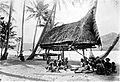
 Koiari village near Bootless Inlet, British New Guinea (from History of Papua New Guinea)
 -
 Flag under German control of New Guinea. (from History of Papua New Guinea)
 -
 Australian troops at Milne Bay, Papua.The Australian garrison was the first to inflict defeat on the Imperial Japanese Army during World War II at the Battle of Milne Bay of Aug–Sep 1942. (from History of Papua New Guinea)
 -
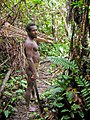 Korowai tribesman (from New Guinea)
 -
 Regions of Oceania: Australasia, Polynesia, Micronesia, and Melanesia. Physiographically, Australasia includes the Australian landmass (including Tasmania), New Zealand, and New Guinea (from New Guinea)
 -
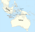 The continent of Sahul before the rising ocean sundered Australia and New Guinea after the last ice age (from New Guinea)
 -
Regions of Oceania: Australasia, Polynesia, Micronesia, and Melanesia. Australasia include the Australian landmass (including Tasmania), New Zealand, and New Guinea. (from History of Papua New Guinea)
-
 The raggiana bird-of-paradise is native to New Guinea. (from New Guinea)
 -
A typical map from the Golden Age of Netherlandish cartography. Australasia during the Golden Age of Dutch exploration and discovery (ca. 1590s–1720s): including Nova Guinea (New Guinea), Nova Hollandia (mainland Australia), Van Diemen's Land (Tasmania), and Nova Zeelandia (New Zealand). (from History of Papua New Guinea)
-
 Mount Bosavi (from New Guinea)
 -
 Papuans on the Lorentz River, photographed during the third South New Guinea expedition in 1912–13 (from New Guinea)
 -

-
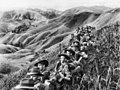 Australian soldiers resting in the Finisterre Ranges of New Guinea while en route to the front line (from New Guinea)
 -
 A Japanese military map of New Guinea from 1943 (from New Guinea)
 -
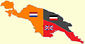 New Guinea from 1884 to 1919. The Netherlands controlled the western half of New Guinea, Germany the north-eastern part, and Britain the south-eastern part. (from New Guinea)
 -
 The floristic region of Malesia (from New Guinea)
 -
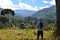 Highlands of Papua New Guinea (from New Guinea)
 -
 Map of New Guinea, with place names as used in English in the 1940s (from New Guinea)
 -
 Political divisions of New Guinea (2006) (from New Guinea)
 -
 Western New Guinea was formally annexed by Indonesia in 1969. (from New Guinea)
 -
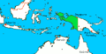
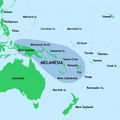 New Guinea located in relation to Melanesia (from New Guinea)
 -
 Dutch expeditions in Netherlands New Guinea 1907–1915. (from History of Western New Guinea)
 -
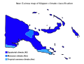 Papua New Guinea map of Köppen climate classification (from New Guinea)
 -
 Hoisting the German flag at Mioko in 1884 (from History of Papua New Guinea)
 -

-
 An Australian soldier, Private George "Dick" Whittington, is aided by Papuan orderly Raphael Oimbari, near Buna on 25 December 1942. (from History of Papua New Guinea)
 -
 Coral reefs in Papua New Guinea (from New Guinea)
 -

-
 Yali Mabel, Kurulu Village War Chief at Baliem Valley (from New Guinea)
 -
Map showing the combined landmass of Sahul formed during Pleistocene glacations (from New Guinea)
-
 Topographical map of New Guinea (from New Guinea)
 -
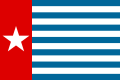 Since 2002, display of the flag of West Papua is allowed in West Papua only if accompanied by, and not raised higher than, the flag of Indonesia. (from History of Western New Guinea)


Related portals
WikiProjects
General topics
Categories

Associated Wikimedia
The following Wikimedia Foundation sister projects provide more on this subject:
-
 Commons
Free media repository -
 Wikibooks
Free textbooks and manuals -
 Wikidata
Free knowledge base -
 Wikinews
Free-content news -
 Wikiquote
Collection of quotations -
 Wikisource
Free-content library -
 Wikiversity
Free learning tools -
 Wiktionary
Dictionary and thesaurus
External media

More portals


Purge server cache

Recent Comments