Original file (3,000 × 4,000 pixels, file size: 4.82 MB, MIME type: image/jpeg)
Summary
DescriptionPalfauer Wasserlochklamm Ohrwaschlbaum 2012-08 Naturdenkmal 975.jpg |
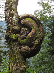
Deutsch: An dem Weg durch die Wasserlochklamm bei Palfau steht ein Baum dessen eigenartige Wucherung an menschliches Ohr erinnert und deshalb Ohrwaschlbaum genannt wird.
English: A tree with a burl on the way to the ravine Wasserlochklamm at Palfau, Styria. The burl resembles a human ear and thus this tree is called Ohrwaschlbaum (dialect for earlap tree).
|
Date | |
Source | Own work |
Author | Duke of W4 |
Camera location | 47° 42′ 15.65″ N, 14° 52′ 39.4″ E | View this and other nearby images on: OpenStreetMap | 47.704347; 14.877610 |
---|
Licensing
- You are free:
- to share – to copy, distribute and transmit the work
- to remix – to adapt the work
- Under the following conditions:
- attribution – You must give appropriate credit, provide a link to the license, and indicate if changes were made. You may do so in any reasonable manner, but not in any way that suggests the licensor endorses you or your use.
- share alike – If you remix, transform, or build upon the material, you must distribute your contributions under the same or compatible license as the original.
This image was uploaded as part of Wiki Loves Earth 2014.
aragonés | العربية | asturianu | azərbaycanca | беларуская (тарашкевіца) | български | বাংলা | brezhoneg | català | čeština | Cymraeg | Deutsch | Ελληνικά | English | español | eesti | euskara | فارسی | français | galego | עברית | hrvatski | հայերեն | Bahasa Indonesia | italiano | 日本語 | ქართული | 한국어 | latviešu | македонски | മലയാളം | मराठी | Bahasa Melayu | norsk bokmål | नेपाली | Nederlands | norsk | polski | português | português do Brasil | русский | sicilianu | shqip | slovenščina | српски / srpski | svenska | ไทย | Türkçe | українська | اردو | 中文 | 中文(台灣) | |
This image won the 1st prize in the national contest of Austria in Wiki Loves Earth 2014 Other languages:
العربيَّة | বাংলা | Deutsch | Ελληνικά | English | español | français | hrvatski | Indonesia | italiano | македонски | Nederlands | português | română | русский | slovenščina | svenska | українська | |
Items portrayed in this file
depicts
creator
some value
copyright status
copyrighted
copyright license
Creative Commons Attribution-ShareAlike 3.0 Austria
coordinates of the point of view
47°42'15.6506"N, 14°52'39.3960"E
source of file
original creation by uploader
inception
10 August 2012
captured with
Canon PowerShot SX210 IS
participant in
Wiki Loves Earth 2014
File history
Click on a date/time to view the file as it appeared at that time.
Date/Time | Thumbnail | Dimensions | User | Comment | |
---|---|---|---|---|---|
current | 08:21, 28 May 2014 | 3,000 × 4,000 (4.82 MB) | Duke of W4 | User created page with UploadWizard |
File usage
Global file usage
The following other wikis use this file:
- Usage on de.wikipedia.org
- Usage on es.wikipedia.org
- Usage on meta.wikimedia.org
Metadata
This file contains additional information, probably added from the digital camera or scanner used to create or digitize it.
If the file has been modified from its original state, some details may not fully reflect the modified file.
Camera manufacturer | Canon |
---|---|
Camera model | Canon PowerShot SX210 IS |
Copyright holder |
|
Exposure time | 1/50 sec (0.02) |
F-number | f/4 |
ISO speed rating | 80 |
Date and time of data generation | 14:47, 10 August 2012 |
Lens focal length | 11.489 mm |
Latitude | 47° 42′ 15.65″ N |
Longitude | 14° 52′ 39.4″ E |
Altitude | 768.7 meters above sea level |
Author | Duke of W4 |
Orientation | Normal |
Horizontal resolution | 180 dpi |
Vertical resolution | 180 dpi |
Software used | Adobe Photoshop Elements 8.0 Windows |
File change date and time | 06:57, 27 May 2014 |
Y and C positioning | Co-sited |
Exif version | 2.21 |
Date and time of digitizing | 14:47, 10 August 2012 |
Meaning of each component |
|
Image compression mode | 3 |
Shutter speed | 5.65625 |
APEX aperture | 4 |
Exposure bias | −1.3333333333333 |
Maximum land aperture | 4 APEX (f/4) |
Metering mode | Pattern |
Flash | Flash did not fire, compulsory flash suppression |
Supported Flashpix version | 1 |
Color space | sRGB |
Focal plane X resolution | 17,802.197802198 |
Focal plane Y resolution | 17,777.777777778 |
Focal plane resolution unit | inches |
Sensing method | One-chip color area sensor |
File source | Digital still camera |
Custom image processing | Normal process |
Exposure mode | Manual exposure |
White balance | Manual white balance |
Digital zoom ratio | 1 |
Scene capture type | Standard |
GPS time (atomic clock) | 12:47 |
Geodetic survey data used | WGS-84 |
GPS date | 10 August 2012 |
GPS tag version | 0.0.2.2 |
IIM version | 61,174 |
Supported Flashpix version | 1 |
Image width | 3,000 px |
Image height | 4,000 px |
Date metadata was last modified | 08:57, 27 May 2014 |
Unique ID of original document | xmp.did:7B43C9FB5AE5E311ACE0A534377D35E0 |
-
Annuals36
-
Bulbs, Corms & Tubers41
-
Ferns27
-
Fruits3
-
Garden Plants23
-
Grasses26
-
Herb17
-
Insects1
-
Mammals1
-
Midwest Native Plants0
-
Northeast Native Plants112
-
Perennials123
-
Rose1
-
Shrubs47
-
Trees112
-
Tropical Plants53
-
Upland Birds5
-
Vines18
-
Viola Tricolor1
-
Water Gardening & Plants9
-
Waterfowl0
-
Wetland Birds0
-
Wetland Plants4
-
Wildbirds172
-
Wildflowers1
-
Woodland Plants29
Recent Comments