![File:Musée de plein air (Tallinn) (7644656256).jpg](https://upload.wikimedia.org/wikipedia/commons/thumb/d/dc/Mus%C3%A9e_de_plein_air_%28Tallinn%29_%287644656256%29.jpg/800px-Mus%C3%A9e_de_plein_air_%28Tallinn%29_%287644656256%29.jpg)
Original file (1,536 × 1,024 pixels, file size: 1.51 MB, MIME type: image/jpeg)
Summary
DescriptionMusée de plein air (Tallinn) (7644656256).jpg |
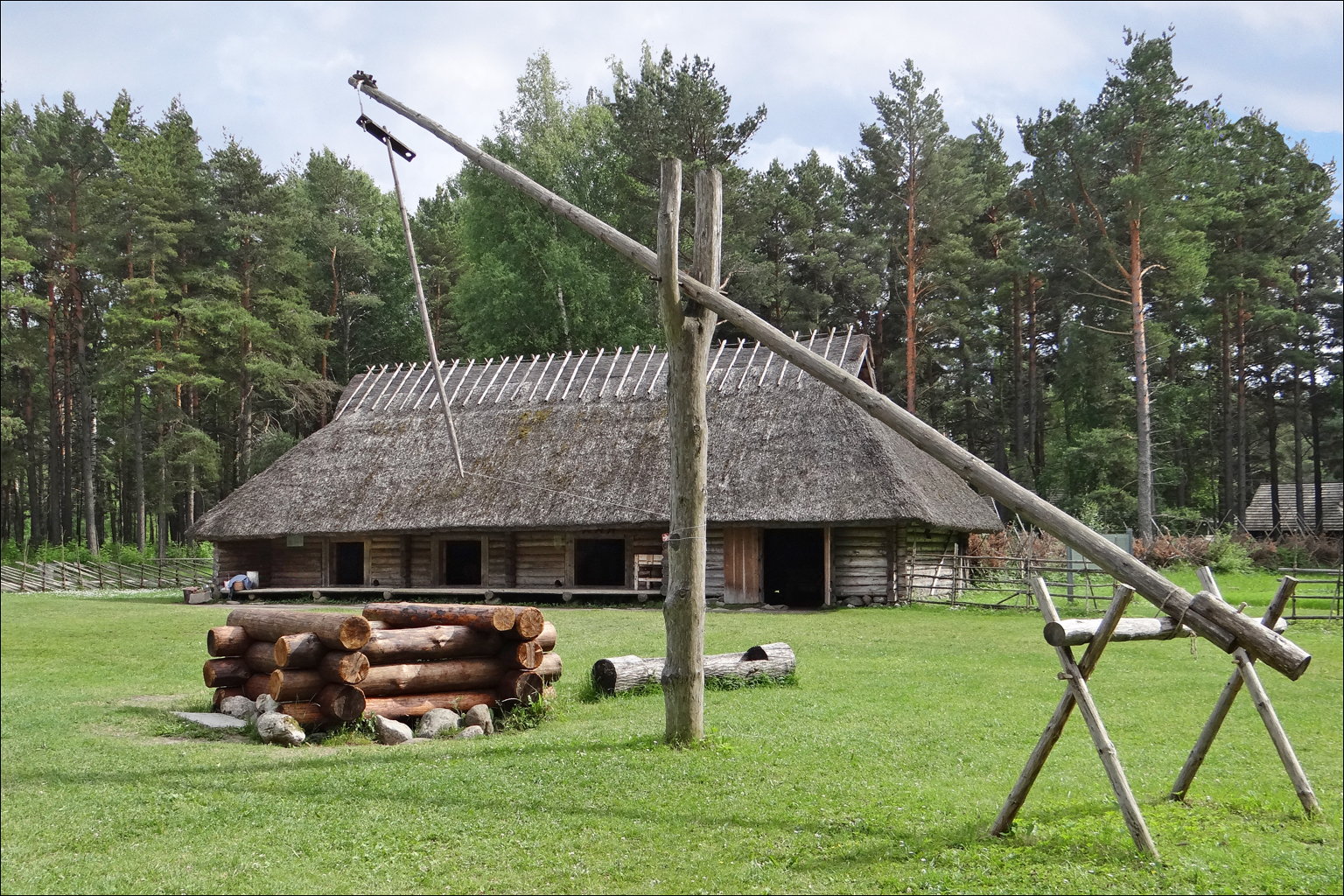
Bâtiment d'habitation Ferme (de taille moyenne) de Sassi-Jaani, du début du 19ème siècle à l'époque du servage, caractéristique de l'ouest de l'Estonie Site du musée ethnographique de plein air www.evm.ee/id/180/ Ce musée ethnographique de plein air se trouve dans une zone très boisée située au bord de la Baltique. Il est bien organisé, chaque ferme est meublée et bien documentée. Néanmoins en raison de la taille de l'Estonie, les maisons se ressemblent un peu, ce qui le rend moins attractif que les musées de plein air scandinaves. Il est conseillé de le visiter en vélo (locations possibles à l'entrée) en raison des distances importantes entre les maisons. Il est également utile d'apporter un produit de protection contre les moustiques qui sont très nombreux en forêt. |
Date | |
Source | Musée de plein air (Tallinn) |
Author | dalbera from Paris, France |
Camera location | 59° 25′ 57.37″ N, 24° 38′ 17.77″ E ![]() | View this and other nearby images on: OpenStreetMap | ![]() |
---|
Licensing
![w:en:Creative Commons](https://upload.wikimedia.org/wikipedia/commons/thumb/7/79/CC_some_rights_reserved.svg/90px-CC_some_rights_reserved.svg.png)
![attribution](https://upload.wikimedia.org/wikipedia/commons/thumb/1/11/Cc-by_new_white.svg/24px-Cc-by_new_white.svg.png)
- You are free:
- to share – to copy, distribute and transmit the work
- to remix – to adapt the work
- Under the following conditions:
- attribution – You must give appropriate credit, provide a link to the license, and indicate if changes were made. You may do so in any reasonable manner, but not in any way that suggests the licensor endorses you or your use.
![]() |
This image, originally posted to Flickr, was reviewed on 15 February 2013 by the administrator or reviewer File Upload Bot (Magnus Manske), who confirmed that it was available on Flickr under the stated license on that date. |
Captions
Items portrayed in this file
depicts
creator
some value
published in
Flickr
copyright status
copyrighted
copyright license
Creative Commons Attribution 2.0 Generic
coordinates of the point of view
59°25'57.367"N, 24°38'17.768"E
captured with
Sony Cyber-shot DSC-HX200V
inception
1 July 2012
source of file
file available on the internet
exposure time
0.002 second
f-number
3.2
focal length
6.05 millimetre
ISO speed
100
media type
image/jpeg
instance of
photograph
Flickr photo ID
File history
Click on a date/time to view the file as it appeared at that time.
Date/Time | Thumbnail | Dimensions | User | Comment | |
---|---|---|---|---|---|
current | 16:06, 15 February 2013 | ![]() | 1,536 × 1,024 (1.51 MB) | File Upload Bot (Magnus Manske) | Transferred from Flickr by User:russavia |
File usage
Global file usage
The following other wikis use this file:
Metadata
This file contains additional information, probably added from the digital camera or scanner used to create or digitize it.
If the file has been modified from its original state, some details may not fully reflect the modified file.
Camera manufacturer | SONY |
---|---|
Camera model | DSC-HX200V |
Exposure time | 1/500 sec (0.002) |
F-number | f/3.2 |
ISO speed rating | 100 |
Date and time of data generation | 16:42, 1 July 2012 |
Lens focal length | 6.05 mm |
Latitude | 59° 25′ 57.36″ N |
Longitude | 24° 38′ 17.77″ E |
Altitude | 0.4 meters below sea level |
Orientation | Normal |
Horizontal resolution | 350 dpi |
Vertical resolution | 350 dpi |
Software used | Adobe Photoshop CS4 Windows |
File change date and time | 16:58, 25 July 2012 |
Y and C positioning | Co-sited |
Exposure Program | Normal program |
Exif version | 2.3 |
Date and time of digitizing | 16:42, 1 July 2012 |
Meaning of each component |
|
Image compression mode | 4 |
APEX brightness | 8.56796875 |
Exposure bias | 0 |
Maximum land aperture | 3.359375 APEX (f/3.2) |
Metering mode | Pattern |
Light source | Unknown |
Flash | Flash did not fire, compulsory flash suppression |
Supported Flashpix version | 1 |
Color space | sRGB |
File source | Digital still camera |
Scene type | A directly photographed image |
Custom image processing | Normal process |
Exposure mode | Auto exposure |
White balance | Auto white balance |
Digital zoom ratio | 1 |
Scene capture type | Standard |
Contrast | Normal |
Saturation | Normal |
Sharpness | Normal |
GPS time (atomic clock) | 13:42 |
Receiver status | Measurement in progress |
Measurement mode | 3-dimensional measurement |
Measurement precision | Poor (1.57) |
Speed unit | Kilometers per hour |
Speed of GPS receiver | 12.996 |
Reference for direction of movement | True direction |
Direction of movement | 329.71 |
Reference for direction of image | Magnetic direction |
Direction of image | 145.25 |
Geodetic survey data used | WGS-84 |
GPS date | 1 July 2012 |
GPS differential correction | 0 |
GPS tag version | 2.3.0.0 |
Supported Flashpix version | 1 |
Image width | 1,536 px |
Image height | 1,024 px |
Unique ID of original document | uuid:faf5bdd5-ba3d-11da-ad31-d33d75182f1b |
Date metadata was last modified | 18:58, 25 July 2012 |
Keywords |
|
IIM version | 60,057 |
-
Annuals36
-
Bulbs, Corms & Tubers41
-
Ferns27
-
Fruits3
-
Garden Plants23
-
Grasses26
-
Herb17
-
Insects1
-
Mammals1
-
Midwest Native Plants0
-
Northeast Native Plants112
-
Perennials123
-
Rose1
-
Shrubs47
-
Trees112
-
Tropical Plants53
-
Upland Birds5
-
Vines18
-
Viola Tricolor1
-
Water Gardening & Plants9
-
Waterfowl0
-
Wetland Birds0
-
Wetland Plants4
-
Wildbirds172
-
Wildflowers1
-
Woodland Plants29
Recent Comments