How Can We Help?
You are here:
< Back
Size of this preview: 800 × 564 pixels. Other resolutions: 320 × 225 pixels | 640 × 451 pixels | 1,024 × 721 pixels | 1,289 × 908 pixels.
Original file (1,289 × 908 pixels, file size: 190 KB, MIME type: image/jpeg)
Summary
DescriptionGrey Rhebok 2017 08 22 5546.jpg |
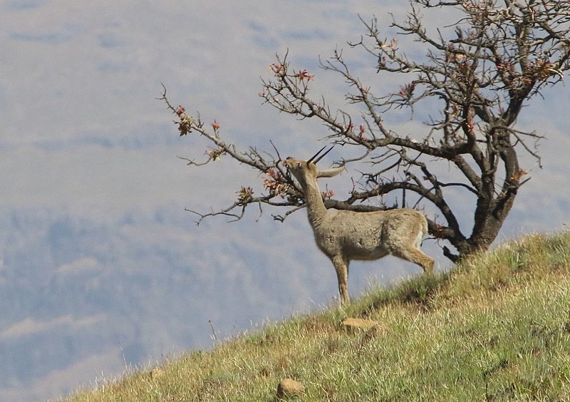
English: Male Grey Rhebok Pelea capreolus browsing from a Protea caffra tree; Mikes Pass, KwaZulu-Natal Drakensberg, South Africa. |
Date | |
Source | Own work |
Author | Alandmanson |
Other versions |
Camera location | 28° 57′ 59.09″ S, 29° 14′ 08.44″ E | View this and other nearby images on: OpenStreetMap | -28.966415; 29.235678 |
---|
Licensing
I, the copyright holder of this work, hereby publish it under the following license:
This file is licensed under the Creative Commons Attribution-Share Alike 4.0 International license.
- You are free:
- to share – to copy, distribute and transmit the work
- to remix – to adapt the work
- Under the following conditions:
- attribution – You must give appropriate credit, provide a link to the license, and indicate if changes were made. You may do so in any reasonable manner, but not in any way that suggests the licensor endorses you or your use.
- share alike – If you remix, transform, or build upon the material, you must distribute your contributions under the same or compatible license as the original.
Items portrayed in this file
depicts
creator
some value
object has role: photographer
author name string: Alandmanson
Wikimedia username: Alandmanson
copyright status
copyrighted
copyright license
Creative Commons Attribution-ShareAlike 4.0 International
inception
22 August 2017
coordinates of the point of view
28°57'59.094"S, 29°14'8.441"E
captured with
Canon EOS 7D Mark II
source of file
original creation by uploader
File history
Click on a date/time to view the file as it appeared at that time.
Date/Time | Thumbnail | Dimensions | User | Comment | |
---|---|---|---|---|---|
current | 10:50, 25 August 2017 | 1,289 × 908 (190 KB) | Alandmanson | User created page with UploadWizard |
File usage
The following pages on the English Wikipedia use this file (pages on other projects are not listed):
Global file usage
The following other wikis use this file:
- Usage on es.wikipedia.org
- Usage on hu.wikipedia.org
- Usage on it.wikipedia.org
- Usage on nv.wikipedia.org
- Usage on ta.wikipedia.org
- Usage on ur.wikipedia.org
Metadata
This file contains additional information, probably added from the digital camera or scanner used to create or digitize it.
If the file has been modified from its original state, some details may not fully reflect the modified file.
Camera manufacturer | Canon |
---|---|
Camera model | Canon EOS 7D Mark II |
Author | Alan Manson |
Exposure time | 1/2,500 sec (0.0004) |
F-number | f/10 |
ISO speed rating | 1,250 |
Date and time of data generation | 13:44, 22 August 2017 |
Lens focal length | 350 mm |
Latitude | 28° 57′ 59.09″ S |
Longitude | 29° 14′ 8.44″ E |
Altitude | 1,808.7 meters above sea level |
Orientation | Normal |
Horizontal resolution | 350 dpi |
Vertical resolution | 350 dpi |
Software used | Digital Photo Professional |
File change date and time | 13:44, 22 August 2017 |
Y and C positioning | Centered |
Exposure Program | Manual |
Exif version | 2.3 |
Date and time of digitizing | 13:44, 22 August 2017 |
Meaning of each component |
|
Shutter speed | 11.375 |
APEX aperture | 6.625 |
Exposure bias | 0 |
Metering mode | Pattern |
Flash | Flash did not fire, compulsory flash suppression |
DateTime subseconds | 68 |
DateTimeOriginal subseconds | 68 |
DateTimeDigitized subseconds | 68 |
Supported Flashpix version | 1 |
Color space | sRGB |
Custom image processing | Normal process |
Exposure mode | Manual exposure |
White balance | Auto white balance |
Scene capture type | Standard |
GPS time (atomic clock) | 11:44:38.862 |
Satellites used for measurement | 22 |
Receiver status | Measurement in progress |
Measurement mode | 3-dimensional measurement |
Measurement precision | Fair (1.9) |
Reference for direction of image | Magnetic direction |
Geodetic survey data used | WGS-84 |
GPS date | 22 August 2017 |
GPS tag version | 0.0.3.2 |
Rating (out of 5) | 1 |
Categories
-
Annuals36
-
Bulbs, Corms & Tubers41
-
Ferns27
-
Fruits3
-
Garden Plants23
-
Grasses26
-
Herb17
-
Insects1
-
Mammals1
-
Midwest Native Plants0
-
Northeast Native Plants112
-
Perennials123
-
Rose1
-
Shrubs47
-
Trees112
-
Tropical Plants53
-
Upland Birds5
-
Vines18
-
Viola Tricolor1
-
Water Gardening & Plants9
-
Waterfowl0
-
Wetland Birds0
-
Wetland Plants4
-
Wildbirds172
-
Wildflowers1
-
Woodland Plants29
Table of Contents
Recent Comments