
How Can We Help?

Size of this preview: 800 × 533 pixels. Other resolutions: 320 × 213 pixels | 640 × 427 pixels | 1,024 × 683 pixels | 1,280 × 853 pixels | 2,560 × 1,707 pixels | 5,184 × 3,456 pixels.
Original file (5,184 × 3,456 pixels, file size: 2.58 MB, MIME type: image/jpeg)
Summary
| Description |
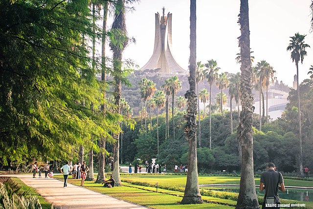
English: The Botanical Garden of Hamma, also known as The Test Garden Hamma is a 58-hectare (140-acre) botanical garden (38 hectares (94 acres) of gardens and 20 hectares (49 acres) of arboretum) located in the Mohamed Belouizdad (formerly Hamma-Anassers) district of Algiers. It was established in 1832 and is now still considered one of the most important botanical gardens in the world.
Français : French: Jardin Botanique du Hamma ou Jardin d'Essai du Hamma
العربية: Jardin d'Essai du Hamma |
| Date | |
| Source | Own work |
| Author | Khaled zouaoui |
| Camera location | | View this and other nearby images on: OpenStreetMap |
|---|
Assessment

|
This image was awarded with the 2nd prize in the national contest of Algeria in Wiki Loves Monuments 2016 Other languages:
|

|
This image was uploaded as part of Wiki Loves Monuments 2016.
|
 |
Licensing
I, the copyright holder of this work, hereby publish it under the following license:
This file is licensed under the Creative Commons Attribution-Share Alike 4.0 International license.
- You are free:
- to share – to copy, distribute and transmit the work
- to remix – to adapt the work
- Under the following conditions:
- attribution – You must give appropriate credit, provide a link to the license, and indicate if changes were made. You may do so in any reasonable manner, but not in any way that suggests the licensor endorses you or your use.
- share alike – If you remix, transform, or build upon the material, you must distribute your contributions under the same or compatible license as the original.
File history
Click on a date/time to view the file as it appeared at that time.
| Date/Time | Thumbnail | Dimensions | User | Comment | |
|---|---|---|---|---|---|
| current | 21:58, 7 September 2016 | | 5,184 × 3,456 (2.58 MB) | Khaled zouaoui | User created page with UploadWizard |
File usage
The following pages on the English Wikipedia use this file (pages on other projects are not listed):
Global file usage
The following other wikis use this file:
- Usage on ar.wikipedia.org
- الوطن العربي
- بوابة:الجزائر/مقالة مختارة/1
- السياحة في الجزائر
- بوابة:الوطن العربي/مدينة مختارة/13
- بوابة:الوطن العربي/مدينة مختارة/أرشيف
- قالب:أكبر المناطق الحضرية في الوطن العربي
- بوابة:الجزائر/مقالة مختارة
- بوابة:المغرب العربي/صورة مختارة
- بوابة:المغرب العربي/صورة مختارة/أرشيف
- بوابة:المغرب العربي/صورة مختارة/2
- بوابة:مدينة الجزائر
- بوابة:مدينة الجزائر/افتتاحية
- بوابة:الجزائر/افتتاحية
- Usage on arz.wikipedia.org
- Usage on es.wikipedia.org
- Usage on fa.wikipedia.org
- Usage on fr.wikipedia.org
- Usage on he.wikipedia.org
- Usage on hi.wikipedia.org
- Usage on id.wikipedia.org
- Usage on ilo.wikipedia.org
- Usage on it.wikipedia.org
- Usage on la.wikipedia.org
- Usage on mt.wikipedia.org
- Usage on nl.wikipedia.org
- Usage on ps.wikipedia.org
- Usage on sr.wikipedia.org
- Usage on www.wikidata.org

Recent Comments