
Ulmarra is a small town on the south bank of the Clarence River in New South Wales, Australia in the Clarence Valley district. At the 2006 census, Ulmarra had a population of 446 people.[2]
The town had the distinction of being the smallest local government area of New South Wales until 2000 when it amalgamated with the Nymboida Shire to form Pristine Waters Shire, which later merged with Copmanhurst, Grafton and Maclean Shires to become the Clarence Valley Council.[3]
Ulmarra's name comes from an Aboriginal word meaning "Bend in the river".[4]
The Ulmarra Ferry was a vehicular cable ferry, which crosses the Clarence River from a point about 1 kilometre (0.62 mi) north of Ulmarra, to Southgate on the north bank. It closed in June 2024.[5]
-
 Map of the town of Grafton New South Wales in 1886, by John Sands
 -
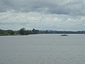 The Clarence River, with the Ulmarra Ferry


| Year | Pop. | ±% |
|---|---|---|
| 1921 | 2,008 | — |
| 1933 | 1,985 | −1.1% |
| 1947 | 1,633 | −17.7% |
| 1954 | 1,499 | −8.2% |
| 1961 | — | |
| 1966 | — | |
| 1971 | 358 | — |
| 1976 | 362 | +1.1% |
| 1981 | 395 | +9.1% |
| 1986 | 462 | +17.0% |
| 1991 | 508 | +10.0% |
| 1996 | 472 | −7.1% |
| 2001 | 492 | +4.2% |
| 2006 | 446 | −9.3% |
| 2011 | 435 | −2.5% |
| 2016 | 437 | +0.5% |
| 2021 | 418 | −4.3% |
| Source: Australian Bureau of Statistics data.[6][7] | ||
References
- ^ Australian Bureau of Statistics (27 June 2017). "Ulmarra (State Suburb)". 2016 Census QuickStats. Retrieved 19 April 2018.
- ^ Australian Bureau of Statistics (25 October 2007). "Ulmarra (L) (Urban Centre/Locality)". 2006 Census QuickStats. Retrieved 7 February 2010.
- ^ "Ulmarra Shire Council". Ulmarra Shire Council. Archived from the original on 19 August 2006. Retrieved 2 October 2006.
- ^ "Ulmarra". Geographical Names Register (GNR) of NSW. Geographical Names Board of New South Wales. Retrieved 11 August 2013.
- ^ Ulmarra Ferry Transport for NSW
- ^ "Statistics by Catalogue Number". Australian Bureau of Statistics. Retrieved 8 January 2024.
- ^ "Search Census data". Australian Bureau of Statistics. Retrieved 8 January 2024.

Recent Comments