| Year | | |
|---|
| 1875 | 951 | — |
|---|
| 1890 | 1,167 | +1.37% |
|---|
| 1910 | 2,318 | +3.49% |
|---|
| 1925 | 3,387 | +2.56% |
|---|
| 1933 | 4,993 | +4.97% |
|---|
| 1939 | 6,648 | +4.89% |
|---|
| 1946 | 7,023 | +0.79% |
|---|
| 1950 | 7,148 | +0.44% |
|---|
| 1964 | 6,967 | −0.18% |
|---|
| 1971 | 6,911 | −0.12% |
|---|
| 1981 | 6,325 | −0.88% |
|---|
| 1985 | 6,122 | −0.81% |
|---|
| 1989 | 5,602 | −2.19% |
|---|
| 1990 | 5,510 | −1.64% |
|---|
| 1991 | 5,422 | −1.60% |
|---|
| | Year | | |
|---|
| 1992 | 5,377 | −0.83% |
|---|
| 1993 | 5,370 | −0.13% |
|---|
| 1994 | 5,423 | +0.99% |
|---|
| 1995 | 5,417 | −0.11% |
|---|
| 1996 | 5,491 | +1.37% |
|---|
| 1997 | 5,721 | +4.19% |
|---|
| 1998 | 6,055 | +5.84% |
|---|
| 1999 | 6,290 | +3.88% |
|---|
| 2000 | 6,518 | +3.62% |
|---|
| 2001 | 6,632 | +1.75% |
|---|
| 2002 | 6,800 | +2.53% |
|---|
| 2003 | 6,961 | +2.37% |
|---|
| 2004 | 7,108 | +2.11% |
|---|
| 2005 | 7,219 | +1.56% |
|---|
| 2006 | 7,360 | +1.95% |
|---|
| | Year | | |
|---|
| 2007 | 7,492 | +1.79% |
|---|
| 2008 | 7,650 | +2.11% |
|---|
| 2009 | 7,774 | +1.62% |
|---|
| 2010 | 7,819 | +0.58% |
|---|
| 2011 | 7,748 | −0.91% |
|---|
| 2012 | 7,827 | +1.02% |
|---|
| 2013 | 7,833 | +0.08% |
|---|
| 2014 | 7,881 | +0.61% |
|---|
| 2015 | 8,019 | +1.75% |
|---|
| 2016 | 8,017 | −0.02% |
|---|
| 2017 | 8,096 | +0.99% |
|---|
| 2018 | 8,134 | +0.47% |
|---|
| 2019 | 8,133 | −0.01% |
|---|
| 2020 | 8,132 | −0.01% |
|---|
|

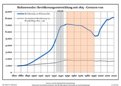 Development of population since 1875 within the current boundaries (blue line: population; dotted line: comparison to population development of Brandenburg state)
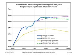 Recent Population Development (Blue Line) and Forecasts

Recent Comments