
| Main Portal page | Indices | Projects |
 |
 |

| |
The Caribbean (/ˌkærɪˈbiːən, kəˈrɪbiən/ KARR-ih-BEE-ən, kə-RIB-ee-ən, locally /ˈkærɪbiːæn/ KARR-ih-bee-an; Spanish: el Caribe; French: les Caraïbes; Dutch: de Caraïben) is a subregion of the Americas that includes the Caribbean Sea and its islands, some of which are surrounded by the Caribbean Sea and some of which border both the Caribbean Sea and the North Atlantic Ocean; the nearby coastal areas on the mainland are sometimes also included in the region. The region is south-east of the Gulf of Mexico and Northern America, east of Central America, and north of South America.
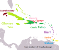
Situated largely on the Caribbean Plate, the region has more than 700 islands, islets, reefs, and cays. Island arcs delineate the northern and eastern edges of the Caribbean Sea: the Greater Antilles in the north and the Lesser Antilles, which includes the Leeward Antilles, in the east and south. The nearby Lucayan Archipelago, comprising The Bahamas and the Turks and Caicos Islands, is considered to be a part of the Caribbean despite not bordering the Caribbean Sea. All the islands in the Antilles plus the Lucayan Archipelago form the West Indies, which is often interchangeable with the term Caribbean. On the mainland, Belize, the eastern and northern coasts of Central and South American countries such as the Bay Islands Department of Honduras, the North and South Caribbean Autonomous Regions of Nicaragua, the Limón Province of Costa Rica, and the Archipelago of San Andrés, Providencia and Santa Catalina of Colombia are also considered culturally Caribbean. French Guiana, Guyana, Panama, and Suriname are often included as parts of the Caribbean due to their political and cultural ties with the region.
Geopolitically, the islands of the Caribbean are often regarded as a subregion of North America, though sometimes they are included in Middle America or left as a subregion of their own; alternately, the term "Caribbean" may have the intended exclusion, or even unintentional inclusion, as part of Latin America. Generally the Caribbean area is organized into 33 political entities, including 13 sovereign states, 12 dependencies, historical disputed territories have existed, and seven other overseas territories. From 15 December 1954 to 10 October 2010, there was a territory known as the Netherlands Antilles composed of five islands, all of which were Dutch dependencies. From 3 January 1958 to 31 May 1962, there was also a short-lived political union called the British West Indies Federation composed of ten English-speaking Caribbean territories, all of which were then British dependencies. (Full article...)
 Good article -

The Invasion of Dominica (7 September 1778) was a successful French invasion of the island of Dominica in the British West Indies, during the American Revolutionary War. The action took place before British authorities in the Caribbean were aware that France had entered the war as an ally of the United States of America. The French governor in the West Indies, François Claude Amour, marquis de Bouillé, was notified on 17 August that France was at war, and organized the invasion, infiltrating spies to rally sympathetic French-speaking Dominican support.
Early on 7 September 1778, French forces landed on the southeastern coast of the island. They rapidly took over some of the island's defenses, and eventually gained control of the high ground overlooking the island's capital, Roseau. Lieutenant Governor William Stuart then surrendered the remaining forces. Dominica remained in French hands until the end of the war, when it was returned to British control. (Full article...)Selected geography article -

Curaçao (/ˈkjʊərəsoʊ, -saʊ, ˌkjʊərəˈsoʊ, -ˈsaʊ/ KURE-ə-soh, KURE-ə-sow, kure-ə-SOH, or kure-ə-SOW, Dutch: [kyːraːˈsʌu] or [kuːr-], Papiamentu: [ˈkɔrsɔu̯]), officially the Country of Curaçao (Dutch: Land Curaçao; Papiamentu: Pais Kòrsou), is a Lesser Antilles island in the southern Caribbean Sea, specifically the Dutch Caribbean region, about 65 km (40 mi) north of Venezuela. It is a constituent country of the Kingdom of the Netherlands.
Curaçao includes the main island of Curaçao and much smaller, uninhabited island of Klein Curaçao ("Little Curaçao"). Curaçao has a population of 158,665 (January 2019 est.), with an area of 444 km2 (171 sq mi); its capital is Willemstad. Together with Aruba and Bonaire, Curaçao forms the ABC islands. Collectively, Curaçao, Aruba, and other Dutch islands in the Caribbean are often called the Dutch Caribbean. It is the largest of the ABC islands in area and population, and the largest of the Dutch Caribbean. (Full article...)Selected fare or cuisine -
Did you know? -

- ...that the Economy of Jamaica was given a boost after the discovery in the 1940s of bauxite (pictured), an aluminium ore?
- ...that at a performance in Havana, the Welsh rock band Manic Street Preachers dedicated their song "You Love Us" to Cuban boxing legend Félix Savón?
- ...that the major settlements on the island of Saba in the Netherlands Antilles are named Windwardside, The Bottom and Hell's Gate?
Related portals
Wikiproject
 Featured article -

The Lesser Antillean macaw or Guadeloupe macaw (Ara guadeloupensis) is a hypothetical extinct species of macaw that is thought to have been endemic to the Lesser Antillean island region of Guadeloupe. In spite of the absence of conserved specimens, many details about the Lesser Antillean macaw are known from several contemporary accounts, and the bird is the subject of some illustrations. Austin Hobart Clark described the species on the basis of these accounts in 1905. Due to the lack of physical remains, and the possibility that sightings were of macaws from the South American mainland, doubts have been raised about the existence of this species. A phalanx bone from the island of Marie-Galante confirmed the existence of a similar-sized macaw inhabiting the region prior to the arrival of humans and was correlated with the Lesser Antillean macaw in 2015. Later that year, historical sources distinguishing between the red macaws of Guadeloupe and the scarlet macaw (A. macao) of the mainland were identified, further supporting its validity.
According to contemporary descriptions, the body of the Lesser Antillean macaw was red and the wings were red, blue and yellow. The tail feathers were between 38 and 51 cm (15 and 20 in) long. Apart from the smaller size and the all-red coloration of the tail feathers, it resembled the scarlet macaw and may, therefore, have been a close relative of that species. The bird ate fruit – including the poisonous manchineel, was monogamous, nested in trees and laid two eggs once or twice a year. Early writers described it as being abundant in Guadeloupe, but it was becoming rare by 1760, and only survived in uninhabited areas. Disease and hunting by humans are thought to have eradicated it shortly afterward. The Lesser Antillean macaw is one of 13 extinct macaw species that have been proposed to have lived in the Caribbean islands. Many of these species are now considered dubious because only three are known from physical remains, and there are no extant endemic macaws on the islands today. (Full article...)Selected image -

Selected music -
Extempo (also extempo calypso) is a lyrically improvised form of calypso and is most notably practiced in Grenada and Trinidad and Tobago. It consists of performers improvising in song or in rhythmic speech on a given theme before an audience, which take turns to perform. It is inherently competitive, and success is judged by the wit and the ingenuity of the performance.
It is similar in form to what has been defined as traditional African song: "a recitative or chants with a short chorus. The soloist gives the melody while a chorus sings a refrain. As the melody is given out, they turn to one another, each improvising in turn. Extempo tends to comprise topics from current events treated with mockery, ridicule and sarcasm, or with flattery or praise.” (Full article...)General images
-
-
 United States' rescue effort at St. Vincent, 1902, following an eruption of the volcano at La Soufrière. (from History of the Caribbean)
 -
 Spanish Caribbean Islands in the American Viceroyalties 1600. (from History of the Caribbean)
 -
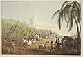
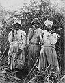 Cane cutters in Jamaica, 1880s. (from History of the Caribbean)
 -
 Crane Resort old and new buildings, Cobblers Reef, Barbados (from Tourism in Latin America and the Caribbean)
 -
 Illustration circa 1815 showing "Incendie du Cap" (Burning of Cape Francais) during the Haitian Revolution. The caption reads: "General revolt of the Blacks. Massacre of the Whites". (from History of the Caribbean)
 -
 Political evolution of Central America and the Caribbean from 1700 to present (from History of the Caribbean)
 -
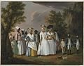 Agostino Brunias. Free Women of Color with Their Children and Servants in a Landscape, ca. 1770-1796 Brooklyn Museum (from Culture of the Caribbean)
 -
 A 1906 advertisement in the Montreal Medical Journal, showing the United Fruit Company selling trips to Jamaica. (from History of the Caribbean)
 -

-
 Battle of the Saintes by Thomas Mitchell. This 1782 battle between the British and French navies took place near Guadeloupe. (from History of the Caribbean)
 -
 Contemporary political map of the Caribbean (from History of the Caribbean)
 -
 A carriage on a street in Martinique, one of the Caribbean islands that has not become independent. It is an overseas region of France, and its citizens are full French citizens. (from History of the Caribbean)
 -
 The Natives of Cumaná attack the mission after Gonzalo de Ocampo's slaving raid. Colored copperplate by Theodor de Bry, published in the "Relación brevissima de la destruccion de las Indias". (from History of the Caribbean)
 -
 A medallion showing the Capture of Trinidad and Tobago by the British in 1797. (from History of the Caribbean)
 -

-
 A container ship docked in the deep water harbour of Bridgetown, Barbados, which opened in 1961. (from History of the Caribbean)
 -
 Linguistic map of the Caribbean in CE 1500, before European colonization (from History of the Caribbean)
 -
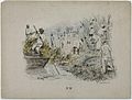
 A linen market in the British West Indies, circa 1780 (from History of the Caribbean)
 -
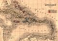 Map of Antilles / Caribbean in 1843. (from History of the Caribbean)
 -
 A 19th-century lithograph by Theodore Bray showing a sugarcane plantation. On right is "white officer", the European overseer, surveilling plantation workers. To the left is a flat-bottomed vessel for cane transportation. (from History of the Caribbean)
 -
 American 757 on final approach to Saint Maarten Airport (from Tourism in Latin America and the Caribbean)
 -
 Sir Ralph Abercromby, Commander of the British forces that captured Trinidad and Tobago. (from History of the Caribbean)
 -
 Bath Hotel, Nevis, photograph by Jose Anjo of Antigua (from Tourism in Latin America and the Caribbean)
 -
 The forced African migrants brought to the Caribbean lived in inhumane conditions. Above are examples of slave huts in Dutch Bonaire. About 5 feet tall and 6 feet wide, between 2 and 3 slaves slept in these after working in nearby salt mines. (from History of the Caribbean)
 -
 The Piazza at Havana by Dominic Serres. The Piazza of Havana, Cuba occupied by British troops following the Siege of Havana, in 1762, during the Seven Years' War. (from History of the Caribbean)


Caribbean topics
Categories

New articles
Rules | Match log | Results page (for watching) | Last updated: 2024-06-20 19:46 (UTC)
Note: The list display can now be customized by each user. See List display personalization for details.
- Faride ( | talk | history | links | watch | logs | tools) by WikiOriginal-9 (talk · contribs · new pages (287)) started on 2024-06-20, score: 16
- Horace Brown (album) ( | talk | history | links | watch | logs | tools) by L to the K (talk · contribs · new pages (4)) started on 2024-06-20, score: 32
- Dera Gay ( | talk | history | links | watch | logs | tools) by Kallmemel (talk · contribs · new pages (1)) started on 2024-06-20, score: 24
- April Mayes ( | talk | history | links | watch | logs | tools) by Sdkb (talk · contribs · new pages (18)) started on 2024-06-20, score: 43
- Jean-Claude Josaphat ( | talk | history | links | watch | logs | tools) by Das osmnezz (talk · contribs · new pages (29)) started on 2024-06-20, score: 16
- Carlos Ventura ( | talk | history | links | watch | logs | tools) by Das osmnezz (talk · contribs · new pages (29)) started on 2024-06-20, score: 40
- Janine Fondon ( | talk | history | links | watch | logs | tools) by Aazaczyns (talk · contribs · new pages (1)) started on 2024-06-19, score: 16
- MV Commodore Goodwill ( | talk | history | links | watch | logs | tools) by Richardh1976 (talk · contribs · new pages (1)) started on 2024-06-19, score: 16
- The Cheetah Girls (novel series) ( | talk | history | links | watch | logs | tools) by BlueSoul004 (talk · contribs · new pages (1)) started on 2024-06-19, score: 24
- List of volcanoes in the Caribbean ( | talk | history | links | watch | logs | tools) by CareAhLine (talk · contribs · new pages (1)) started on 2024-06-08, score: 99
- Titanes del Distrito ( | talk | history | links | watch | logs | tools) by 寒吉 (talk · contribs · new pages (9)) started on 2024-06-19, score: 16
- Richaxxhaitian ( | talk | history | links | watch | logs | tools) by Roastedbeanz1 (talk · contribs · new pages (17)) started on 2024-06-19, score: 16
- 1965 CONCACAF Championship squads ( | talk | history | links | watch | logs | tools) by SuperSkaterDude45 (talk · contribs · new pages (4)) started on 2024-06-19, score: 16
- King's Stand Stakes ( | talk | history | links | watch | logs | tools) by JockeyColours (talk · contribs · new pages (3)) started on 2024-06-19, score: 16
- University of Uélé ( | talk | history | links | watch | logs | tools) by Achiri Bitamsimli (talk · contribs · new pages (92)) started on 2024-06-19, score: 16
- Farley Chavez Augustine ( | talk | history | links | watch | logs | tools) by PtolemyXV (talk · contribs · new pages (1)) started on 2024-06-19, score: 24
- Esteban Ventura Novo ( | talk | history | links | watch | logs | tools) by Wikidude2243 (talk · contribs · new pages (1)) started on 2024-06-19, score: 16
- List of Kappa Mu Epsilon chapters ( | talk | history | links | watch | logs | tools) by Rublamb (talk · contribs · new pages (10)) started on 2024-06-18, score: 16
- Ladeco ( | talk | history | links | watch | logs | tools) by Hector Ossa J. (talk · contribs · new pages (1)) started on 2024-06-18, score: 20
- José Corporán ( | talk | history | links | watch | logs | tools) by BlkGeneral2000 (talk · contribs · new pages (13)) started on 2024-06-18, score: 32
- José Antonio Figueroa ( | talk | history | links | watch | logs | tools) by BlkGeneral2000 (talk · contribs · new pages (13)) started on 2024-06-18, score: 16
- Benigno del Castillo ( | talk | history | links | watch | logs | tools) by BlkGeneral2000 (talk · contribs · new pages (13)) started on 2024-06-18, score: 24
- Juan Erazo ( | talk | history | links | watch | logs | tools) by BlkGeneral2000 (talk · contribs · new pages (13)) started on 2024-06-18, score: 32
- Rudecindo de León ( | talk | history | links | watch | logs | tools) by BlkGeneral2000 (talk · contribs · new pages (13)) started on 2024-06-18, score: 16
- Tomás Pimentel ( | talk | history | links | watch | logs | tools) by BlkGeneral2000 (talk · contribs · new pages (13)) started on 2024-06-18, score: 16
- Fernando Tavera ( | talk | history | links | watch | logs | tools) by BlkGeneral2000 (talk · contribs · new pages (13)) started on 2024-06-18, score: 24
- List of Dominicans on canonization process ( | talk | history | links | watch | logs | tools) by JB Hoang Tam 2 (talk · contribs · new pages (12)) started on 2024-06-18, score: 24
- Byron Messia ( | talk | history | links | watch | logs | tools) by 2RDD (talk · contribs · new pages (6)) started on 2024-06-17, score: 24
- Miss Grand Florida ( | talk | history | links | watch | logs | tools) by Thomson Walt (talk · contribs · new pages (2)) started on 2024-06-18, score: 16
- 2024–25 Dallas Mavericks season ( | talk | history | links | watch | logs | tools) by Donnowin1 (talk · contribs · new pages (14)) started on 2024-06-18, score: 16
- Climate finance in Jamaica ( | talk | history | links | watch | logs | tools) by Susty3 (talk · contribs · new pages (1)) started on 2024-06-18, score: 32
- Melany Krywoj ( | talk | history | links | watch | logs | tools) by Vecihi91 (talk · contribs · new pages (7)) started on 2024-06-18, score: 12
- La Piraña Lechonera ( | talk | history | links | watch | logs | tools) by Another Believer (talk · contribs · new pages (164)) started on 2024-06-18, score: 16
- List of Arnold Air Society chapters ( | talk | history | links | watch | logs | tools) by Rublamb (talk · contribs · new pages (10)) started on 2024-06-18, score: 16
- Roberto Durán vs. Esteban de Jesús III ( | talk | history | links | watch | logs | tools) by Beast from da East (talk · contribs · new pages (5)) started on 2024-06-18, score: 16
- Criticism of Apple Inc. ( | talk | history | links | watch | logs | tools) by Shushugah (talk · contribs · new pages (8)) started on 2024-06-17, score: 16
- Alicia Herrero Liñana ( | talk | history | links | watch | logs | tools) by Vecihi91 (talk · contribs · new pages (7)) started on 2024-06-17, score: 12
- Arnold Thomasos ( | talk | history | links | watch | logs | tools) by Cheney123 (talk · contribs · new pages (17)) started on 2024-06-17, score: 16
- Wahid Ali ( | talk | history | links | watch | logs | tools) by Cheney123 (talk · contribs · new pages (17)) started on 2024-06-17, score: 16
- Occah Seapaul ( | talk | history | links | watch | logs | tools) by Cheney123 (talk · contribs · new pages (17)) started on 2024-06-17, score: 32
- ByronMessia ( | talk | history | links | watch | logs | tools) by 2RDD (talk · contribs · new pages (6)) started on 2024-06-17, score: 24
- Danielle De Jesus ( | talk | history | links | watch | logs | tools) by MichaelaBlanc (talk · contribs · new pages (4)) started on 2024-06-14, score: 16
- Detroit Wayne (1919 ship) ( | talk | history | links | watch | logs | tools) by Jordanroderick (talk · contribs · new pages (2)) started on 2024-06-11, score: 24
- Irina Kovalchuk ( | talk | history | links | watch | logs | tools) by Maniakilljoy97 (talk · contribs · new pages (24)) started on 2024-06-17, score: 16
- Pavilion+ ( | talk | history | links | watch | logs | tools) by CaribbeanCurator (talk · contribs · new pages (1)) started on 2024-06-17, score: 32
- Frank Savage ( | talk | history | links | watch | logs | tools) by Chaiten1 (talk · contribs · new pages (2)) started on 2024-06-17, score: 32
- Tin Tin Deo ( | talk | history | links | watch | logs | tools) by Kku (talk · contribs · new pages (6)) started on 2024-06-17, score: 16
- Leah Bertrand ( | talk | history | links | watch | logs | tools) by Hildreth gazzard (talk · contribs · new pages (173)) started on 2024-06-17, score: 32
- List of Alpha Chi chapters ( | talk | history | links | watch | logs | tools) by Rublamb (talk · contribs · new pages (10)) started on 2024-06-17, score: 32
- Rod Price (wrestler) ( | talk | history | links | watch | logs | tools) by Kingzwest (talk · contribs · new pages (4)) started on 2024-06-17, score: 16
- List of people with prostate cancer ( | talk | history | links | watch | logs | tools) by SomeBodyAnyBody05 (talk · contribs · new pages (3)) started on 2024-06-17, score: 40
- 2022 FIVB Men's Volleyball Challenger Cup ( | talk | history | links | watch | logs | tools) by BilledMammal (talk · contribs · new pages (75)) started on 2024-06-16, score: 16
- Urania P. Cummings ( | talk | history | links | watch | logs | tools) by Adjoajo (talk · contribs · new pages (1)) started on 2024-06-16, score: 32
- Marcos Evangelista Adón ( | talk | history | links | watch | logs | tools) by BlkGeneral2000 (talk · contribs · new pages (13)) started on 2024-06-16, score: 76
- William A.C. Ryan ( | talk | history | links | watch | logs | tools) by EssNS (talk · contribs · new pages (11)) started on 2024-06-16, score: 16
- Joseph Fry (captain) ( | talk | history | links | watch | logs | tools) by EssNS (talk · contribs · new pages (11)) started on 2024-06-16, score: 24
- Bernabé Varona ( | talk | history | links | watch | logs | tools) by EssNS (talk · contribs · new pages (11)) started on 2024-06-16, score: 16
- Jesús del Sol ( | talk | history | links | watch | logs | tools) by EssNS (talk · contribs · new pages (11)) started on 2024-06-16, score: 24
- Teresa Titos Garzón ( | talk | history | links | watch | logs | tools) by JB Hoang Tam 2 (talk · contribs · new pages (12)) started on 2024-06-16, score: 16
- Corn Islands Town Hall ( | talk | history | links | watch | logs | tools) by Nic505 (talk · contribs · new pages (2)) started on 2024-06-16, score: 16
- 2024 dengue outbreak in Latin America and the Caribbean ( | talk | history | links | watch | logs | tools) by Noble Attempt (talk · contribs · new pages (19)) started on 2024-06-16, score: 24
- Marcos Evangelista Adon ( | talk | history | links | watch | logs | tools) by BlkGeneral2000 (talk · contribs · new pages (13)) started on 2024-06-16, score: 76
- Edgar T. Collins ( | talk | history | links | watch | logs | tools) by Billmckern (talk · contribs · new pages (3)) started on 2024-06-16, score: 16
- Geodetic Facility for the Advancement of Geoscience ( | talk | history | links | watch | logs | tools) by Starlighsky (talk · contribs · new pages (5)) started on 2024-06-15, score: 16
- Tamisha (given name) ( | talk | history | links | watch | logs | tools) by Hyphenation Expert (talk · contribs · new pages (12)) started on 2024-06-15, score: 16
- Battle of El Pepino ( | talk | history | links | watch | logs | tools) by Lionel Cristiano (talk · contribs · new pages (13)) started on 2024-06-15, score: 16
- John MacLellan, 7th Lord Kirkcudbright ( | talk | history | links | watch | logs | tools) by Mcclellan28 (talk · contribs · new pages (1)) started on 2024-06-15, score: 32
- England at the ICC Men's T20 World Cup ( | talk | history | links | watch | logs | tools) by Cric editor (talk · contribs · new pages (16)) started on 2024-06-14, score: 16
- Corma tamosi ( | talk | history | links | watch | logs | tools) by Aubuh3 (talk · contribs · new pages (1)) started on 2024-06-11, score: 16
- Claudia de Angelis ( | talk | history | links | watch | logs | tools) by JB Hoang Tam 2 (talk · contribs · new pages (12)) started on 2024-06-15, score: 16
- Domenica Narducci ( | talk | history | links | watch | logs | tools) by JB Hoang Tam 2 (talk · contribs · new pages (12)) started on 2024-06-15, score: 16
- Maria Rosa Agostini ( | talk | history | links | watch | logs | tools) by JB Hoang Tam 2 (talk · contribs · new pages (12)) started on 2024-06-15, score: 16
- Colegio Sagrados Corazones Recoleta ( | talk | history | links | watch | logs | tools) by AlejandroFC (talk · contribs · new pages (49)) started on 2024-06-15, score: 16
- The Adventures of Tintin publication history ( | talk | history | links | watch | logs | tools) by Artem.G (talk · contribs · new pages (18)) started on 2024-06-15, score: 16
- José Quevedo Pérez ( | talk | history | links | watch | logs | tools) by Wikiuser17 (talk · contribs · new pages (1)) started on 2024-06-15, score: 16
- Deaths in November 1986 ( | talk | history | links | watch | logs | tools) by Drewsky1211 (talk · contribs · new pages (3)) started on 2024-06-14, score: 24
- Columba Schonath ( | talk | history | links | watch | logs | tools) by JB Hoang Tam 2 (talk · contribs · new pages (12)) started on 2024-06-14, score: 16
- Francisca Dorotea ( | talk | history | links | watch | logs | tools) by JB Hoang Tam 2 (talk · contribs · new pages (12)) started on 2024-06-14, score: 16
- 2024 BRICS Games ( | talk | history | links | watch | logs | tools) by Habst (talk · contribs · new pages (83)) started on 2024-06-14, score: 16
- Parmentiera aculeata ( | talk | history | links | watch | logs | tools) by AllTheUsernamesAreInUse (talk · contribs · new pages (41)) started on 2024-06-14, score: 19
- RA12 ( | talk | history | links | watch | logs | tools) by Denniscabrams (talk · contribs · new pages (7)) started on 2024-06-11, score: 24
- England at the T20 World Cup ( | talk | history | links | watch | logs | tools) by Cric editor (talk · contribs · new pages (16)) started on 2024-06-14, score: 16
- Timoteo Ogando ( | talk | history | links | watch | logs | tools) by BlkGeneral2000 (talk · contribs · new pages (13)) started on 2024-06-14, score: 44
- Rally 'Round the West Indies ( | talk | history | links | watch | logs | tools) by Basetornado (talk · contribs · new pages (2)) started on 2024-06-14, score: 40
- Deaths in December 1986 ( | talk | history | links | watch | logs | tools) by Drewsky1211 (talk · contribs · new pages (3)) started on 2024-06-14, score: 24
- Johnny Hajjar ( | talk | history | links | watch | logs | tools) by Moondragon21 (talk · contribs · new pages (93)) started on 2024-06-14, score: 16
- Marcellin Nadeau ( | talk | history | links | watch | logs | tools) by Moondragon21 (talk · contribs · new pages (93)) started on 2024-06-14, score: 16
- Cyclone Alvaro ( | talk | history | links | watch | logs | tools) by Hurricane Noah (talk · contribs · new pages (2)) started on 2024-06-14, score: 16
- 2024 United National Congress internal election ( | talk | history | links | watch | logs | tools) by Arimaboss (talk · contribs · new pages (1)) started on 2024-06-14, score: 16
- List of Orenstein & Koppel steam locomotives ( | talk | history | links | watch | logs | tools) by Opolito (talk · contribs · new pages (1)) started on 2024-06-14, score: 48
- María Baltasara de los Reyes ( | talk | history | links | watch | logs | tools) by BlkGeneral2000 (talk · contribs · new pages (13)) started on 2024-06-14, score: 24
- Jim Redmond ( | talk | history | links | watch | logs | tools) by MoviesandTelevisionFan (talk · contribs · new pages (17)) started on 2024-06-13, score: 16
- New Popular Front ( | talk | history | links | watch | logs | tools) by Bejakyo (talk · contribs · new pages (4)) started on 2024-06-10, score: 16
- Nadeska Cuthbert ( | talk | history | links | watch | logs | tools) by Nic505 (talk · contribs · new pages (2)) started on 2024-06-13, score: 16
- Shaquan Davis (footballer) ( | talk | history | links | watch | logs | tools) by Thplam2004 (talk · contribs · new pages (31)) started on 2024-06-13, score: 24
- 2025 Men's Softball World Cup Group A ( | talk | history | links | watch | logs | tools) by Kezyfooty (talk · contribs · new pages (4)) started on 2024-06-13, score: 16
- Andy Rojas (footballer) ( | talk | history | links | watch | logs | tools) by Thplam2004 (talk · contribs · new pages (31)) started on 2024-06-13, score: 16
- Romualdez family ( | talk | history | links | watch | logs | tools) by TheNuggeteer (talk · contribs · new pages (49)) started on 2024-06-13, score: 16
- 2024 Little League World Series results ( | talk | history | links | watch | logs | tools) by Stan394 (talk · contribs · new pages (1)) started on 2024-06-13, score: 24
- Roberto Durán vs. Esteban de Jesús II ( | talk | history | links | watch | logs | tools) by Beast from da East (talk · contribs · new pages (5)) started on 2024-06-13, score: 16
- Civilizations (novel) ( | talk | history | links | watch | logs | tools) by Yaseen.Kader (talk · contribs · new pages (2)) started on 2024-06-13, score: 16
- Jiovanny William ( | talk | history | links | watch | logs | tools) by Moondragon21 (talk · contribs · new pages (93)) started on 2024-06-12, score: 16
- The Latin Alternative ( | talk | history | links | watch | logs | tools) by Sammi Brie (talk · contribs · new pages (9)) started on 2024-06-12, score: 16
- Eusebio Puello ( | talk | history | links | watch | logs | tools) by BlkGeneral2000 (talk · contribs · new pages (13)) started on 2024-06-11, score: 92
- Emerging Ireland cricket team ( | talk | history | links | watch | logs | tools) by Godknowme1 (talk · contribs · new pages (1)) started on 2024-06-11, score: 32
- 2022–23 Liga Puerto Rico season ( | talk | history | links | watch | logs | tools) by Yeahimaboss413 (talk · contribs · new pages (6)) started on 2024-06-11, score: 43
- 2023–24 Liga Puerto Rico season ( | talk | history | links | watch | logs | tools) by Yeahimaboss413 (talk · contribs · new pages (6)) started on 2024-06-11, score: 35
- Roberto Durán vs. Esteban de Jesús ( | talk | history | links | watch | logs | tools) by Beast from da East (talk · contribs · new pages (5)) started on 2024-06-11, score: 16
- The Latin Alternative (Radio Program) ( | talk | history | links | watch | logs | tools) by TheNuggeteer (talk · contribs · new pages (49)) started on 2024-06-11, score: 16
- Diablos Rojos (bus) ( | talk | history | links | watch | logs | tools) by TheNuggeteer (talk · contribs · new pages (49)) started on 2024-06-11, score: 16
- He Knows ( | talk | history | links | watch | logs | tools) by Bryantriplex (talk · contribs · new pages (1)) started on 2024-06-11, score: 16
- Anthony León (tenor) ( | talk | history | links | watch | logs | tools) by Gor1995 (talk · contribs · new pages (2)) started on 2024-06-10, score: 16
- Paul Noel Fiorino ( | talk | history | links | watch | logs | tools) by Microplastic Consumer (talk · contribs · new pages (22)) started on 2024-06-08, score: 16
- Gabriele Dell′Oglio ( | talk | history | links | watch | logs | tools) by Gri3720 (talk · contribs · new pages (7)) started on 2024-06-10, score: 32
- Nikolai Mushegian ( | talk | history | links | watch | logs | tools) by Consutema (talk · contribs · new pages (1)) started on 2024-06-10, score: 16
- Justice Malone ( | talk | history | links | watch | logs | tools) by BD2412 (talk · contribs · new pages (431)) started on 2024-06-10, score: 32
- Justice Knowles ( | talk | history | links | watch | logs | tools) by BD2412 (talk · contribs · new pages (431)) started on 2024-06-10, score: 16
- 2020s in Latin music ( | talk | history | links | watch | logs | tools) by Magiciandude (talk · contribs · new pages (3)) started on 2024-06-10, score: 16
- Christal ( | talk | history | links | watch | logs | tools) by Toweli (talk · contribs · new pages (62)) started on 2024-06-10, score: 16
- United Nations General Assembly Resolution 78/282 ( | talk | history | links | watch | logs | tools) by Srđan (talk · contribs · new pages (1)) started on 2024-06-10, score: 96
- Sofía Cabrera ( | talk | history | links | watch | logs | tools) by Almagestas (talk · contribs · new pages (9)) started on 2024-06-10, score: 27
- List of British Army first-class cricketers ( | talk | history | links | watch | logs | tools) by Blue Square Thing (talk · contribs · new pages (9)) started on 2024-06-10, score: 16
- 2024 ICC Men's T20 World Cup Super 8 Group 2 ( | talk | history | links | watch | logs | tools) by Spinin (talk · contribs · new pages (3)) started on 2024-06-10, score: 40
- Audley Clarke ( | talk | history | links | watch | logs | tools) by RhodeIslandHistory (talk · contribs · new pages (2)) started on 2024-06-10, score: 16
- Adael Amador ( | talk | history | links | watch | logs | tools) by Yankees10 (talk · contribs · new pages (15)) started on 2024-06-09, score: 16
- Rainer Kensy, Baron of Echlin ( | talk | history | links | watch | logs | tools) by Kellycrak88 (talk · contribs · new pages (37)) started on 2024-06-09, score: 24
- Ramon Bailey ( | talk | history | links | watch | logs | tools) by Shotgun pete (talk · contribs · new pages (1)) started on 2024-06-09, score: 16
- Cortines ( | talk | history | links | watch | logs | tools) by XxTechnicianxX (talk · contribs · new pages (7)) started on 2024-06-09, score: 16
- Michel Otañez ( | talk | history | links | watch | logs | tools) by Muboshgu (talk · contribs · new pages (14)) started on 2024-06-09, score: 16
- Dale Pa'Ya ( | talk | history | links | watch | logs | tools) by Shout4Serenity (talk · contribs · new pages (11)) started on 2024-06-09, score: 24
- Rumble (Skrillex, Fred Again and Flowdan song) ( | talk | history | links | watch | logs | tools) by QuietHere (talk · contribs · new pages (47)) started on 2024-06-09, score: 16
- Musicólogo & Menes ( | talk | history | links | watch | logs | tools) by Sebaspikyaq (talk · contribs · new pages (3)) started on 2024-06-09, score: 16
- Brickell (song) ( | talk | history | links | watch | logs | tools) by Sebaspikyaq (talk · contribs · new pages (3)) started on 2024-06-09, score: 16
- Warren Kanders ( | talk | history | links | watch | logs | tools) by Bridget (talk · contribs · new pages (5)) started on 2024-06-09, score: 16
- Antoine Pierrot ( | talk | history | links | watch | logs | tools) by EssNS (talk · contribs · new pages (11)) started on 2024-06-08, score: 32
- Junior Senneville ( | talk | history | links | watch | logs | tools) by Paul Vaurie (talk · contribs · new pages (27)) started on 2024-06-08, score: 24
- Ariamnes mexicanus ( | talk | history | links | watch | logs | tools) by Fluxjupyter (talk · contribs · new pages (4)) started on 2024-06-08, score: 35
- Cinema of Guinea-Bissau ( | talk | history | links | watch | logs | tools) by Lbal (talk · contribs · new pages (2)) started on 2024-06-08, score: 16
- Richard Mollica ( | talk | history | links | watch | logs | tools) by Accotink (talk · contribs · new pages (2)) started on 2024-06-07, score: 16
- Julio Grave de Peralta ( | talk | history | links | watch | logs | tools) by EssNS (talk · contribs · new pages (11)) started on 2024-06-08, score: 16
- Mora (singer) ( | talk | history | links | watch | logs | tools) by Bkonrad (talk · contribs · new pages (7)) started on 2024-06-08, score: 16
- If I Ruled the World (Big Time Rush song) ( | talk | history | links | watch | logs | tools) by Shout4Serenity (talk · contribs · new pages (11)) started on 2024-06-08, score: 16
- 2024 ICC Men's T20 World Cup Super 8 Group 1 ( | talk | history | links | watch | logs | tools) by Spinin (talk · contribs · new pages (3)) started on 2024-06-08, score: 48
- Juma Miyagi ( | talk | history | links | watch | logs | tools) by Beeeggs (talk · contribs · new pages (3)) started on 2024-06-08, score: 16
- 2024 ICC Men's T20 World Cup final ( | talk | history | links | watch | logs | tools) by Spinin (talk · contribs · new pages (3)) started on 2024-06-08, score: 16
- Eric Velásquez ( | talk | history | links | watch | logs | tools) by Significa liberdade (talk · contribs · new pages (32)) started on 2024-06-08, score: 16
- Gabriel Silva (Panamanian politician) ( | talk | history | links | watch | logs | tools) by Number 57 (talk · contribs · new pages (15)) started on 2024-06-07, score: 16
- Tonia Sutherland ( | talk | history | links | watch | logs | tools) by Stephestellar (talk · contribs · new pages (2)) started on 2024-06-07, score: 16
- Schendylops ( | talk | history | links | watch | logs | tools) by HCUPa (talk · contribs · new pages (15)) started on 2024-06-05, score: 16
- Bordon Camp ( | talk | history | links | watch | logs | tools) by Dormskirk (talk · contribs · new pages (3)) started on 2024-06-07, score: 24
- 2024 NACAC Championships ( | talk | history | links | watch | logs | tools) by Habst (talk · contribs · new pages (83)) started on 2024-06-07, score: 32
- Godfrey Nyakana ( | talk | history | links | watch | logs | tools) by Micheal Kaluba (talk · contribs · new pages (9)) started on 2024-06-07, score: 24
- 2024 CONCACAF Caribbean Cup ( | talk | history | links | watch | logs | tools) by Demt1298 (talk · contribs · new pages (3)) started on 2024-06-07, score: 71
- Legal career of Keir Starmer ( | talk | history | links | watch | logs | tools) by ThingsCanOnlyGetWetter (talk · contribs · new pages (100)) started on 2024-06-06, score: 16
- Lenni Cirino ( | talk | history | links | watch | logs | tools) by Geregen2 (talk · contribs · new pages (22)) started on 2024-06-06, score: 16
- Carlos Ímaz ( | talk | history | links | watch | logs | tools) by Chiffre01 (talk · contribs · new pages (2)) started on 2024-06-06, score: 16
- Agenodesmus ( | talk | history | links | watch | logs | tools) by HCUPa (talk · contribs · new pages (15)) started on 2024-06-06, score: 48
- Carlos Imaz Gispert ( | talk | history | links | watch | logs | tools) by Chiffre01 (talk · contribs · new pages (2)) started on 2024-06-06, score: 16
- Barbara Conolly ( | talk | history | links | watch | logs | tools) by Moondragon21 (talk · contribs · new pages (93)) started on 2024-06-06, score: 16
- Deaths in May 2024 ( | talk | history | links | watch | logs | tools) by Rusted AutoParts (talk · contribs · new pages (1)) started on 2024-06-06, score: 32
- Andy Hechavarría ( | talk | history | links | watch | logs | tools) by Pietaster (talk · contribs · new pages (7)) started on 2024-06-06, score: 24
- Rayvien Rosario ( | talk | history | links | watch | logs | tools) by Ortizesp (talk · contribs · new pages (25)) started on 2024-06-06, score: 16
- CNN Radio Argentina ( | talk | history | links | watch | logs | tools) by JuanjoAvalos (talk · contribs · new pages (1)) started on 2024-06-06, score: 32
- List of Seattle Reign FC seasons ( | talk | history | links | watch | logs | tools) by SounderBruce (talk · contribs · new pages (16)) started on 2024-06-06, score: 16
- Angel Chivilli ( | talk | history | links | watch | logs | tools) by Muboshgu (talk · contribs · new pages (14)) started on 2024-06-06, score: 16
- 1963 Soviet Union regional elections ( | talk | history | links | watch | logs | tools) by Tony24644 (talk · contribs · new pages (4)) started on 2024-06-06, score: 16
- 2024 CFU Club Shield ( | talk | history | links | watch | logs | tools) by Demt1298 (talk · contribs · new pages (3)) started on 2024-06-06, score: 95
- CFU Club Shield ( | talk | history | links | watch | logs | tools) by Demt1298 (talk · contribs · new pages (3)) started on 2024-06-06, score: 27
- Pachira insignis ( | talk | history | links | watch | logs | tools) by BlakeALee (talk · contribs · new pages (3)) started on 2024-06-06, score: 32
Associated Wikimedia
The following Wikimedia Foundation sister projects provide more on this subject:
-
 Commons
Free media repository -
 Wikibooks
Free textbooks and manuals -
 Wikidata
Free knowledge base -
 Wikinews
Free-content news -
 Wikiquote
Collection of quotations -
 Wikisource
Free-content library -
 Wikiversity
Free learning tools -
 Wikivoyage
Free travel guide -
 Wiktionary
Dictionary and thesaurus
-

-

-

-

-

-

-

-

-

-

-
 Random portal
 -


Shortcuts to this page: Portal:West Indies • P:CARIB Purge server cache

Recent Comments