
Original file (1,357 × 353 pixels, file size: 33 KB, MIME type: image/png)
Summary
| Description |
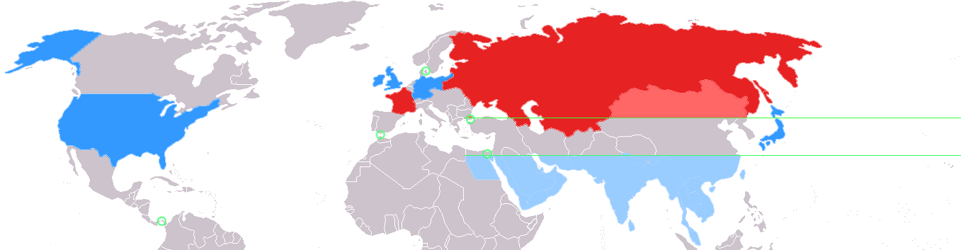
English: This map depicts the world as divided by geostrategist Alfred Thayer Mahan in his 1900 piece The Problem of Asia.
Asia is divided along the 30 north and 40 north parallels, represented here by green lines. Colored in red are the two allied land powers, the Russian Empire and France. In lighter red are the portions of Asia above the 40th parallel under effective influence of Russian land power. Colored in blue are the four allied sea powers, Great Britain, the German Empire, Japan, and the United States. In lighter blue are the portions of Asia below the 30th parallel subject to effective control by sea power. In between the 30th and 40th parallel is what Mahan termed the "Debatable and debated ground," subject to competition between the land powers and sea powers. Circled in green are key isthmuses identified by Mahan: the Suez Canal, Panama Canal, Turkish Straits, Strait of Gibraltar, and Danish Straits. Source |
| Date | 22 December 2006 (original upload date) |
| Source | Transferred from en.wikipedia to Commons. |
| Author | Perceval at English Wikipedia |
Licensing
| This work has been released into the public domain by its author, Perceval at English Wikipedia. This applies worldwide. In some countries this may not be legally possible; if so: Perceval grants anyone the right to use this work for any purpose, without any conditions, unless such conditions are required by law. |
Original upload log
| Date/Time | Dimensions | User | Comment |
|---|---|---|---|
| 2006-12-22 04:06 | 1357×353× (27252 bytes) | Perceval | This map depicts the world as divided by [[geostrategy|geostrategist]] [[Alfred Thayer Mahan]] in his 1900 piece ''[[The Problem of Asia]]''. [[Asia]] is divided along the 30 north and 40 north [[latitude|parallels]], represented here by green lines. Co |
File history
Click on a date/time to view the file as it appeared at that time.
| Date/Time | Thumbnail | Dimensions | User | Comment | |
|---|---|---|---|---|---|
| current | 19:14, 15 March 2022 | 1,357 × 353 (33 KB) | Randomastwritter | added dervish state | |
| 21:09, 5 September 2015 | 1,357 × 353 (27 KB) | Matanya | Transferred from en.wikipedia |
File usage
Global file usage
The following other wikis use this file:
- Usage on he.wikipedia.org
- Usage on ja.wikipedia.org

Recent Comments