
Trempealeau Mountain State Natural Area is a Wisconsin Department of Natural Resources-designated State Natural Area consisting of a 425-foot conical rock mound surrounded on three sides by the Mississippi and Trempealeau Rivers. It is one of only 3 solid rock islands along the entire Mississippi River.[1]
Location and access
Trempealeau Mountain State Natural Area is located in western Trempealeau County approximately 2 miles (3.2 km) southwest of Trempealeau within Perrot State Park. Access is via the Mississippi and Trempealeau Rivers.[2]
Description
Trempealeau Mountain is mostly wooded, dominated by black and white oak and basswood. In a hollow on the southeast-facing side, red oaks are found mixed with patches of interrupted ferns. On the cooler northeast-facing slopes, sugar maple and basswood dominate. The dry south-facing slopes contain small patches of dry prairie with big blue-stem, needle grass, side-oats grama, hairy grama, white and purple prairie-clover, prairie larkspur, and partridge pea. Numerous Native American mounds, burial sites, and habitation sites make this a rich archeological site. French explorers were among the first Europeans to explore the area and the name Trempealeau comes from the French, “la montagne qui trempe à l’eau” meaning “the mountain whose foot is bathed in water”.[1]
-
 Trempealeau Mountain SNA (viewed from Brady's Bluff SNA)
 -
 Hollow on Trempealeau Mountain
 -
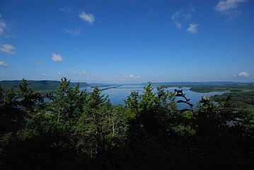 View from Trempealeau Mountain peak
 -
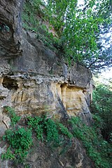 Exposed rockface at Trempealeau Mountain


References
- ^ a b "Trempealeau Mountain State Natural Area". Wisconsin DNR. Retrieved 1 December 2013.
- ^ Trempealeau Mountain State Natural Area (PDF) (Map). Wisconsin Department of Natural Resources. Retrieved 2013-11-29.
External links
- http://dnr.wi.gov/topic/Lands/naturalareas/index.asp?SNA=356 WI DNR
- http://dnr.wi.gov/topic/lands/naturalareas/documents/topomaps/map356.pdf
-
Annuals36
-
Bulbs, Corms & Tubers41
-
Ferns27
-
Fruits3
-
Garden Plants23
-
Grasses26
-
Herb17
-
Insects1
-
Mammals1
-
Midwest Native Plants0
-
Northeast Native Plants112
-
Perennials123
-
Rose1
-
Shrubs47
-
Trees112
-
Tropical Plants53
-
Upland Birds5
-
Vines18
-
Viola Tricolor1
-
Water Gardening & Plants9
-
Waterfowl0
-
Wetland Birds0
-
Wetland Plants4
-
Wildbirds172
-
Wildflowers1
-
Woodland Plants29

Recent Comments