
How Can We Help?

Size of this preview: 777 × 599 pixels. Other resolutions: 311 × 240 pixels | 622 × 480 pixels | 984 × 759 pixels.
Original file (984 × 759 pixels, file size: 74 KB, MIME type: image/png)
Summary
| Description |
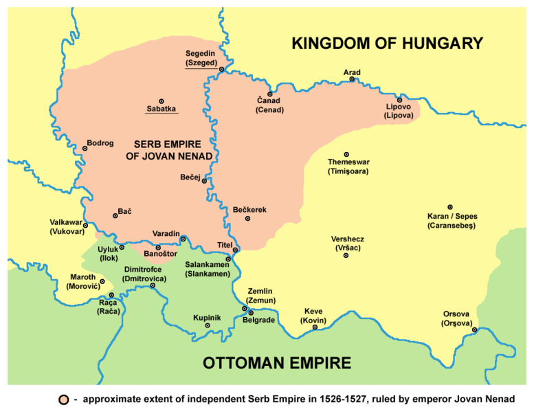
English: historical map showing Serb Empire of Jovan Nenad in 1526-1527, English language version.
Српски / srpski: историјска мапа која приказује Српско царство Јована Ненада 1526-1527. године, верзија на енглеском језику. |
| Date | 9 February 2009 (original upload date) |
| Source | No machine-readable source provided. Own work assumed (based on copyright claims). |
| Author | No machine-readable author provided. PANONIAN assumed (based on copyright claims). |
References
- Veselin P. Dželetović, Poslednji srpski car - Jovan Nenad, Poeta - Beograd, 2007.
- Dr Aleksa Ivić, Istorija Srba u Vojvodini, Novi Sad, 1929.
- Milan Tutorov, Mala Raška a u Banatu, Zrenjanin, 1991.
- Drago Njegovan, Prisajedinjenje Vojvodine Srbiji, Novi Sad, 2004.
- Dr. Dušan J. Popović, Srbi u Vojvodini, knjiga 1, Novi Sad, 1990.
- Peter Rokai, Zoltan Đere, Tibor Pal, Aleksandar Kasaš, Istorija Mađara, Beograd, 2002.
- Vladimir Ćorović, Ilustrovana istorija Srba, knjiga četvrta, Beograd, 2006.
- Dr Milenko Palić, Srbi u Mađarskoj - Ugarskoj do 1918, Novi Sad, 1995.
- The Times History of Europe, Times Books, 2002.
Source and licence
self made map by user:PANONIAN
Licensing
| I, the copyright holder of this work, release this work into the public domain. This applies worldwide. In some countries this may not be legally possible; if so: I grant anyone the right to use this work for any purpose, without any conditions, unless such conditions are required by law. |
File history
Click on a date/time to view the file as it appeared at that time.
| Date/Time | Thumbnail | Dimensions | User | Comment | |
|---|---|---|---|---|---|
| current | 16:57, 14 April 2015 | | 984 × 759 (74 KB) | PANONIAN | corrections |
| 14:54, 29 November 2014 |  | 984 × 759 (74 KB) | PANONIAN | aesthetics | |
| 14:54, 9 November 2011 |  | 982 × 759 (74 KB) | PANONIAN | few corrections: Ilok and Rača were Ottoman, Sotin was controlled by Jovan Nenad | |
| 12:11, 12 July 2009 |  | 982 × 759 (70 KB) | PANONIAN | ||
| 20:06, 16 March 2009 |  | 545 × 452 (43 KB) | PANONIAN | ||
| 23:49, 9 February 2009 |  | 632 × 555 (59 KB) | PANONIAN | historical map of empire of Jovan Nenad - English version (self made) {{PD-self}} Category:Maps of the history of Vojvodina Category:Maps of the history of Serbia |
File usage
The following pages on the English Wikipedia use this file (pages on other projects are not listed):
Global file usage
The following other wikis use this file:
- Usage on bg.wikipedia.org
- Usage on de.wikipedia.org
- Usage on es.wikipedia.org
- Usage on gl.wikipedia.org
- Usage on hr.wikipedia.org
- Usage on ja.wikipedia.org
- Usage on lt.wikipedia.org
- Usage on mk.wikipedia.org
- Usage on ro.wikipedia.org
- Usage on sh.wikipedia.org
- Usage on sl.wikipedia.org

Recent Comments