
The World Portal


The world is the totality of entities, the whole of reality, or everything that exists. The nature of the world has been conceptualized differently in different fields. Some conceptions see the world as unique while others talk of a "plurality of worlds". Some treat the world as one simple object while others analyze the world as a complex made up of parts.
In scientific cosmology, the world or universe is commonly defined as "[t]he totality of all space and time; all that is, has been, and will be". Theories of modality talk of possible worlds as complete and consistent ways how things could have been. Phenomenology, starting from the horizon of co-given objects present in the periphery of every experience, defines the world as the biggest horizon or the "horizon of all horizons". In philosophy of mind, the world is contrasted with the mind as that which is represented by the mind. Theology conceptualizes the world in relation to God, for example, as God's creation, as identical to God or as the two being interdependent. In religions, there is a tendency to downgrade the material or sensory world in favor of a spiritual world to be sought through religious practice. A comprehensive representation of the world and our place in it, as is found in religions, is known as a worldview. Cosmogony is the field that studies the origin or creation of the world while eschatology refers to the science or doctrine of the last things or of the end of the world.
In various contexts, the term "world" takes a more restricted meaning associated, for example, with the Earth and all life on it, with humanity as a whole or with an international or intercontinental scope. In this sense, world history refers to the history of humanity as a whole and world politics is the discipline of political science studying issues that transcend nations and continents. Other examples include terms such as "world religion", "world language", "world government", "world war", "world population", "world economy", or "world championship". (Full article...)
Selected articles -
-

The Rugby World Cup is a men's rugby union tournament contested every four years between the top international teams, the winners of which are recognised as the World champions of the sport.
The tournament is administered by World Rugby, the sport's international governing body. The winners are awarded the Webb Ellis Cup, named after William Webb Ellis who, according to a popular legend, invented rugby by picking up the ball during a football game and running with it. (Full article...) -
The Vendée Globe is a single-handed (solo) non-stop round the world yacht race. The race was founded by Philippe Jeantot in 1989, and since 1992 has taken place every four years. It is named after the Département of Vendée, in France, where the race starts and ends. The Vendée Globe is considered an extreme quest of individual endurance and the ultimate test in ocean racing. (Full article...) -
Planetary management is intentional global-scale management of Earth's biological, chemical and physical processes and cycles (water, carbon, nitrogen, sulfur, phosphorus, and others). Planetary management also includes managing humanity’s influence on planetary-scale processes. Effective planetary management aims to prevent destabilisation of Earth's climate, protect biodiversity and maintain or improve human well-being. More specifically, it aims to benefit society and the global economy, and safeguard the ecosystem services upon which humanity depends – global climate, freshwater supply, food, energy, clean air, fertile soil, pollinators, and so on.
Because of the sheer complexity and enormous scope of the task, it remains to be seen whether planetary management is a feasible paradigm for maintaining global sustainability. The concept currently has defenders and critics on both sides: environmentalist David W. Orr questions whether such a task can be accomplished with human help and technology or without first examining the underlying human causes, while geographer Vaclav Smil acknowledges that "the idea of planetary management may seem preposterous to many, but at this time in history there is no rational alternative". (Full article...) -

Artist's concept of the Earth 5–7.5 billion years from now, when the Sun has become a red giant
While the future cannot be predicted with certainty, present understanding in various scientific fields allows for the prediction of some far-future events, if only in the broadest outline. These fields include astrophysics, which studies how planets and stars form, interact, and die; particle physics, which has revealed how matter behaves at the smallest scales; evolutionary biology, which studies how life evolves over time; plate tectonics, which shows how continents shift over millennia; and sociology, which examines how human societies and cultures evolve.
These timelines begin at the start of the 4th millennium in 3001 CE, and continue until the furthest and most remote reaches of future time. They include alternative future events that address unresolved scientific questions, such as whether humans will become extinct, whether the Earth survives when the Sun expands to become a red giant and whether proton decay will be the eventual end of all matter in the Universe. (Full article...) -
The United Nations Convention to Combat Desertification in Those Countries Experiencing Serious Drought and/or Desertification, Particularly in Africa (UNCCD) is a Convention to combat desertification and mitigate the effects of drought through national action programs that incorporate long-term strategies supported by international cooperation and partnership arrangements.
The Convention, the only convention stemming from a direct recommendation of the Rio Conference's Agenda 21, was adopted in Paris, France, on 17 June 1994 and entered into force in December 1996. It is the only internationally legally binding framework set up to address the problem of desertification. The Convention is based on the principles of participation, partnership and decentralization—the backbone of good governance and sustainable development. It has 197 parties, making it near universal in reach. (Full article...) -
The BWF World Tour is a Grade 2 badminton tournament series, sanctioned by Badminton World Federation (BWF). It is a competition open to the top world ranked players in singles (men's and women's) and doubles (men's, women's and mixed). The competition was announced on 19 March 2017 and came into effect starting from 2018, replacing the BWF Super Series, which was held from 2007 to 2017.
The BWF World Tour are divided into six levels, namely World Tour Finals, Super 1000, Super 750, Super 500, and Super 300 in order (part of the HSBC World Tour). One other category of tournament, the BWF Tour Super 100 level, also offers ranking points. (Full article...) -
Map of global water stress (a symptom of water scarcity) in 2019. Water stress is the ratio of water use relative to water availability and is therefore a demand-driven scarcity.
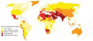
Water scarcity (closely related to water stress or water crisis) is the lack of fresh water resources to meet the standard water demand. There are two type of water scarcity. One is physical. The other is economic water scarcity. Physical water scarcity is where there is not enough water to meet all demands. This includes water needed for ecosystems to function. Regions with a desert climate often face physical water scarcity. Central Asia, West Asia, and North Africa are examples of arid areas. Economic water scarcity results from a lack of investment in infrastructure or technology to draw water from rivers, aquifers, or other water sources. It also results from weak human capacity to meet water demand. Many people in Sub-Saharan Africa are living with economic water scarcity.
There is enough freshwater available globally and averaged over the year to meet demand. As such, water scarcity is caused by a mismatch between when and where people need water, and when and where it is available. One of the main causes of the increase in global water demand is the increase in the number of people. Others are the rise in living conditions, changing diets (to more animal products), and expansion of irrigated agriculture. Climate change (including droughts or floods), deforestation, water pollution and wasteful use of water can also mean there is not enough water. These variations in scarcity may also be a function of prevailing economic policy and planning approaches. (Full article...)


General images -
-
 Change in average surface air temperature and drivers for that change. Human activity has caused increased temperatures, with natural forces adding some variability. (from Earth)
 -
 A schematic view of Earth's magnetosphere with solar wind flowing from left to right (from Earth)
 -

-

-
 A 2012 artistic impression of the early Solar System's protoplanetary disk from which Earth and other Solar System bodies were formed (from Earth)
 -
 Earth's western hemisphere showing topography relative to Earth's center instead of to mean sea level, as in common topographic maps (from Earth)
 -
 A view of Earth with its global ocean and cloud cover, which dominate Earth's surface and hydrosphere; at Earth's polar regions, its hydrosphere forms larger areas of ice cover. (from Earth)
 -
 Lithified stromatolites on the shores of Lake Thetis, Western Australia. Archean stromatolites are the first direct fossil traces of life on Earth. (from History of Earth)
 -
 A view of Earth with different layers of its atmosphere visible: the troposphere with its clouds casting shadows, a band of stratospheric blue sky at the horizon, and a line of green airglow of the lower thermosphere around an altitude of 100 km, at the edge of space (from Earth)
 -
 Pangaea was a supercontinent that existed from about 300 to 180 Ma. The outlines of the modern continents and other landmasses are indicated on this map. (from History of Earth)
 -
 Great Mosque of Kairouan, Tunisia, founded 670 CE
 -
 Trilobites first appeared during the Cambrian period and were among the most widespread and diverse groups of Paleozoic organisms. (from History of Earth)
 -
 A composite image of artificial light emissions at night on a map of Earth (from Earth)
 -
 Last Moon landing: Apollo 17 (1972)
 -
 Florence, birthplace of the Italian Renaissance
 -
 Obelisk of Axum, Ethiopia
 -

-
 Earth's night-side upper atmosphere appearing from the bottom as bands of afterglow illuminating the troposphere in orange with silhouettes of clouds, and the stratosphere in white and blue. Next the mesosphere (pink area) extends to the orange and faintly green line of the lowest airglow, at about one hundred kilometers at the edge of space and the lower edge of the thermosphere (invisible). Continuing with green and red bands of aurorae stretching over several hundred kilometers. (from Earth)
 -
 Artist's rendition of an oxinated fully-frozen Snowball Earth with no remaining liquid surface water. (from History of Earth)
 -
 Japanese depiction of a Portuguese carrack. European maritime innovations led to proto-globalization.
 -
 An animation of the changing density of productive vegetation on land (low in brown; heavy in dark green) and phytoplankton at the ocean surface (low in purple; high in yellow) (from Earth)
 -
 A reconstruction of Pannotia (550 Ma). (from History of Earth)
 -
 Notre-Dame de Paris, France
 -
 Standing Buddha from Gandhara, 2nd century CE
 -
 First airplane, the Wright Flyer, flew on 17 December 1903.
 -
 Taj Mahal, Mughal Empire, India
 -

-
 Cross-section through a liposome (from History of Earth)
 -
 A banded iron formation from the 3.15 Ga Moodies Group, Barberton Greenstone Belt, South Africa. Red layers represent the times when oxygen was available; gray layers were formed in anoxic circumstances. (from History of Earth)
 -
 A composite image of Earth, with its different types of surface discernible: Earth's surface dominating Ocean (blue), Africa with lush (green) to dry (brown) land and Earth's polar ice in the form of Antarctic sea ice (grey) covering the Antarctic or Southern Ocean and the Antarctic ice sheet (white) covering Antarctica. (from Earth)
 -
 Shanghai. China urbanized rapidly in the 21st century.
 -
 A pillar at Göbekli Tepe
 -
 Tracy Caldwell Dyson, a NASA astronaut, observing Earth from the Cupola module at the International Space Station on 11 September 2010 (from Earth)
 -

-
 Artist's impression of Earth during the later Archean, the largely cooled planetary crust and water-rich barren surface, marked by volcanoes and continents, features already round microbialites. The Moon, still orbiting Earth much closer than today and still dominating Earth's sky, produced strong tides. (from History of Earth)
 -
 Chennakesava Temple, Belur, India
 -
 Machu Picchu, Inca Empire, Peru
 -
 An artist's impression of ice age Earth at glacial maximum. (from History of Earth)
 -

-
An artist's impression of the Archean, the eon after Earth's formation, featuring round stromatolites, which are early oxygen-producing forms of life from billions of years ago. After the Late Heavy Bombardment, Earth's crust had cooled, its water-rich barren surface is marked by continents and volcanoes, with the Moon still orbiting Earth half as far as it is today, appearing 2.8 times larger and producing strong tides. (from Earth)
-
 A map of heat flow from Earth's interior to the surface of Earth's crust, mostly along the oceanic ridges (from Earth)
 -
 Empires of the world in 1898
 -
 Ming dynasty section, Great Wall of China
 -
 The replicator in virtually all known life is deoxyribonucleic acid. DNA is far more complex than the original replicator and its replication systems are highly elaborate. (from History of Earth)
 -
 A 580 million year old fossil of Spriggina floundensi, an animal from the Ediacaran period. Such life forms could have been ancestors to the many new forms that originated in the Cambrian Explosion. (from History of Earth)
 -
 Angkor Wat temple complex, Cambodia, early 12th century
 -
 Tiktaalik, a fish with limb-like fins and a predecessor of tetrapods. Reconstruction from fossils about 375 million years old. (from History of Earth)
 -
 A computer-generated image mapping the prevalence of artificial satellites and space debris around Earth in geosynchronous and low Earth orbit (from Earth)
 -
 The pale orange dot, an artist's impression of the early Earth which might have appeared orange through its hazy methane rich prebiotic second atmosphere. Earth's atmosphere at this stage was somewhat comparable to today's atmosphere of Titan. (from History of Earth)
 -
 Image of the physical world, captured by the Hubble Space Telescope (from World)
 -
 View of Earth from the Moon by the Lunar Reconnaissance Orbiter (from Earth)
 -

-
 Graph showing range of estimated partial pressure of atmospheric oxygen through geologic time (from History of Earth)
 -
 Artist's conception of Devonian flora (from History of Earth)
 -
 Earth's history with time-spans of the eons to scale (from History of Earth)
 -

-
 Peopling of the world, the Southern Dispersal scenario
 -

-
Pale orange dot, an artist's impression of Early Earth, featuring its tinted orange methane-rich early atmosphere (from Earth)
-

-
 Chloroplasts in the cells of a moss (from History of Earth)
 -
 Persepolis, Achaemenid Empire, 6th century BCE
 -
 Yggdrasil, an attempt to reconstruct the Norse world tree which connects the heavens, the world, and the underworld. (from World)
 -
 Artist's conception of Hadean Eon Earth, when it was much hotter and inhospitable to all forms of life. (from History of Earth)
 -
 Fall of the Berlin Wall, 1989
 -
 Earth's axial tilt causing different angles of seasonal illumination at different orbital positions around the Sun (from Earth)
 -
 Benin Bronze head from Nigeria
 -

-
 A reconstruction of human history based on fossil data. (from History of Earth)
 -
 Artist's impression of the enormous collision that probably formed the Moon (from History of Earth)
 -

-
 Geologic map of North America, color-coded by age. From most recent to oldest, age is indicated by yellow, green, blue, and red. The reds and pinks indicate rock from the Archean.
 -
 Great Pyramids of Giza, Egypt
 -
 Satellite time lapse imagery of Earth's rotation showing axis tilt (from Earth)
 -

-
 Ajloun Castle, Jordan
 -
 "Lucy", the first Australopithecus afarensis skeleton found, was only 1.06 m (3 ft 6 in) tall.
 -
 Vitruvian Man by Leonardo da Vinci epitomizes the advances in art and science seen during the Renaissance. (from History of Earth)
 -

-
 Artist's impression of a Hadean landscape with the relatively newly formed Moon still looming closely over Earth and both bodies sustaining strong volcanism. (from History of Earth)
 -

-
 Battle during the 1281 Mongol invasion of Japan
 -
 Dinosaurs were the dominant terrestrial vertebrates throughout most of the Mesozoic (from History of Earth)
 -
 Earth's land use for human agriculture in 2019 (from Earth)
 -
 An artist's rendering of a protoplanetary disk (from History of Earth)
 -

-

-
 Olmec colossal head, now at the Museo de Antropología de Xalapa


Megacities of the world -

Xiamen is a sub-provincial city in southeastern Fujian, People's Republic of China, beside the Taiwan Strait. It is divided into six districts: Huli, Siming, Jimei, Tong'an, Haicang, and Xiang'an. All together, these cover an area of 1,700.61 square kilometers (656.61 sq mi) with a population of 5,163,970 as of 2020 and estimated at 5.308 million as of 31 December 2022. The urbanized area of the city has spread from its original island to include most parts of all six of its districts, as well as 4 Zhangzhou districts (Xiangcheng, Longwen, Longhai and Changtai), which form a built-up area of 7,284,148 inhabitants. This area also connects with Quanzhou in the north, making up a metropolis of nearly ten million people. The Kinmen Islands (Quemoy) administered by the Republic of China (Taiwan) lie less than 6 kilometers (4 mi) away separated by Xiamen Bay. As part of the Opening Up Policy under Deng Xiaoping, Xiamen became one of China's original four special economic zones opened to foreign investment and trade in the early 1980s.
Xiamen Island possessed a major international seaport. The port of Xiamen is a well-developed first-class trunk line port in the Asia-Pacific region. It is ranked the 7th-largest container port in China and ranks 13th in the world. It is the 4th port in China with the capacity to handle 6th-generation large container ships. On 31 August 2010, Xiamen Port incorporated the neighboring port of Zhangzhou to form the largest port of China's Southeast. Ever since the 12th century, Xiamen was also an important origin for many migrants to Singapore, Malaysia, Indonesia and the Philippines. The overseas Chinese used to support Xiamen's educational and cultural institutions. Xiamen is classified as a Large-Port Metropolis. (Full article...)Did you know -

- ... that during the First World War, Adrian Becher received his second Military Cross for leading the defence of a position for five days, despite having been buried by a shell explosion on the first day?
- ... that Winston Churchill painted Tower of the Koutoubia Mosque, his only painting during World War II, at the Villa Taylor?
- ... that Lieutenant Colonel Richard John Andrews survived the Second Boer War, the First World War, the Russian Civil War and the Irish War of Independence only to be killed by a defective tool in his garage?
- ... that author Ann Howard interviewed more than 100 Australians about their experiences as child evacuees sent inland during World War II when a Japanese invasion seemed imminent?
- ... that medieval literature scholar Theodore Silverstein's unit in World War II took over the Eiffel Tower to intercept communications of German aircraft?
- ... that Fernhill House has been home to a butter merchant, an Ulster Volunteer Force armoury, a Grand National-winning racehorse and the world's largest collection of Orange Order memorabilia?
- ... that the petunia carnage of 2017 led to worldwide economic losses?
- ... that Alfred Egerton Cooper, a war artist who lost the use of an eye in World War I, painted airships?
Countries of the world -

Jordan, officially the Hashemite Kingdom of Jordan, is a country in the Southern Levant region of West Asia. Jordan is bordered by Syria to the north, Iraq to the east, Saudi Arabia to the south, and Israel and the occupied Palestinian West Bank to the west. The Jordan River, flowing into the Dead Sea, is located along the country's western border. Jordan has a small coastline along the Red Sea in its southwest, separated by the Gulf of Aqaba from Egypt. Amman is Jordan's capital and largest city, as well as the most populous city in the Levant.
Modern-day Jordan has been inhabited by humans since the Paleolithic period. Three kingdoms emerged in Transjordan at the end of the Bronze Age: Ammon, Moab and Edom. In the third century BC, the Arab Nabataeans established their kingdom centered in Petra. Later rulers of the Transjordan region include the Assyrian, Babylonian, Roman, Byzantine, Rashidun, Umayyad, Abbasid, and the Ottoman empires. After the Great Arab Revolt against the Ottomans in 1916 during World War I, the Greater Syria region was partitioned by Britain and France. The Emirate of Transjordan was established in 1921 by the Hashemite, then Emir, Abdullah I, and the emirate became a British protectorate. In 1946, Jordan gained independence and became officially known as the Hashemite Kingdom of Jordan. The country captured and annexed the West Bank during the 1948 Arab–Israeli War until it was occupied by Israel in 1967. Jordan renounced its claim to the territory to the Palestinians in 1988, and signed a peace treaty with Israel in 1994. (Full article...)Related portals
Protected areas of the world -
-
-
Protected areas of Canada consist of approximately 12.1 percent of the nation's landmass and freshwater are considered conservation areas, including 11.4 percent designated as protected areas. Approximately 13.8 percent of Canada's territorial waters are conserved, including 8.9 percent designated as protected areas. Terrestrial areas conserved have increased by 65 percent in the 21st century, while marine areas conserved have increased by more than 3,800 percent.
Conservation and protected areas have different mandates depending on the organization which manages them, with some areas having a greater focus on ecological integrity, historical preservation, public usage, scientific research, or a combination of usages. Some areas such as the Polar Bear Pass, are co-managed and overseen by government and local indigenous agencies. (Full article...) -

Tijuca Forest National Park
Protected areas of Brazil included various classes of area according to the National System of Nature Conservation Units (SNUC), a formal, unified system for federal, state and municipal parks created in 2000. (Full article...) -
The following list of protected areas of British Columbia includes all federally and provincially protected areas within the Canadian province of British Columbia. As of 2015, approximately 15.46% of the province's land area and 3.17% of the province's waters are protected. (Full article...)
-
This is a list of protected areas of Yukon. The Yukon, formerly called Yukon Territory and sometimes referred to as just Yukon is the smallest and westernmost of Canada's three territories. It also is the least populated province or territory in Canada, with a population of 35,874 people as of the 2016 Census. (Full article...) -
Kentucky's system of 44 state parks has been referred to as "the nation's finest" and experiences more repeat business annually than those of any other U.S. state. The state's diverse geography provides a variety of environments to experience. From mountain lakes to expansive caves to forests teeming with wildlife, park-goers have their choice of attractions, and they are all within a day's drive of each other.
Unless otherwise specified, data in the following lists are taken from Kentucky State Parks by Bill Bailey. (Full article...) -
Protected areas of the Caribbean are significant in a region of particular ecological vulnerability, including the impact of climate change and the impact of tourism.
The University of the West Indies' "Caribbean Protected Areas Gateway" supports informational resources for the 16 Caribbean member states of the Organisation of African, Caribbean and Pacific States. It forms the regional component of the ACP's Biodiversity and Protected Areas Management program, building on the World Database on Protected Areas. (Full article...) -

Centre for Nature Education at the Białowieża National Park, Poland
Protected areas of Poland include the following categories, as defined by the Act on Protection of Nature (Polish: Ustawa o ochronie przyrody) of 16 April 2004, by the Polish Parliament: (Full article...) -
Protected areas of Slovenia include one national park (Slovene: narodni park), three regional parks (regijski park), several natural parks (krajinski park), and hundreds of natural monuments (naravni spomenik) and monuments of designed nature (spomenik oblikovane narave). They cover about 12.5% of the Slovenian territory. Under the Wild Birds Directive, 26 sites totalling roughly 25% of the nation's land are "Special Protected Areas"; the Natura 2000 proposal would increase the totals to 260 sites and 32% of national territory. (Full article...)
-
This is a list of protected areas of Romania.
About 5.18% of the area of Romania has a protected status (12,360 km2), including the Danube Delta, which makes half of these areas (2.43% of Romania's area). (Full article...) -

Cranes at Sevan National Park
This is a list of protected areas in Armenia that are categorized as follows: 4 national parks, 3 state reserves, 27 state sanctuaries and 5 botanical gardens. (Full article...) -
The protected areas of South Africa include national parks and marine protected areas managed by the national government, public nature reserves managed by provincial and local governments, and private nature reserves managed by private landowners. Most protected areas are intended for the conservation of flora and fauna. National parks are maintained by South African National Parks (SANParks). A number of national parks have been incorporated in transfrontier conservation areas.
Protected areas may also be protected for their value and importance as historical, cultural heritage or scientific sites. More information on these can be found in the list of heritage sites in South Africa. (Full article...) -
-
The state of Johor in Malaysia is noted for its national parks and forest reserves which preserve virgin rainforests known for its biodiversity and endangered species of animals.
Mangrove swamps and coral reefs are also protected within these parks. (Full article...) -
Protected areas of Tamil Nadu cover an area of 3,305 km2 (1,276 sq mi), constituting 2.54% of the geographic area and 15% of the 22,643 km2 (8,743 sq mi) recorded forest area of the state of Tamil Nadu in South India. It ranks 14th among all the states and union territories of India in terms of total protected area.
Protected areas in South India were created from private hunting grounds of the erstwhile Maharajas of the princely states. Mudumalai National Park was established in 1940 and was the first modern wildlife sanctuary in South India. The protected areas are administered by the Ministry of Environment and Forests of Government of India and the Tamil Nadu Forest Department. (Full article...)


Selected world maps
-
 Time zones of the world
 -
 Only a few of the largest large igneous provinces appear (coloured dark purple) on this geological map, which depicts crustal geologic provinces as seen in seismic refraction data
 -
 1516 map of the world by Martin Waldseemüller
 -
 Mollweide projection of the world
 -
 The world map by Gerardus Mercator (1569), the first map in the well-known Mercator projection
 -
 The Goode homolosine projection is a pseudocylindrical, equal-area, composite map projection used for world maps.
 -
 Index map from the International Map of the World (1:1,000,000 scale)
 -
 A plate tectonics map with volcano locations indicated with red circles
 -
 United Nations Human Development Index map by country (2016)


World records
- List of Olympic records in athletics
- List of world records in athletics
- List of junior world records in athletics
- List of world records in masters athletics
- List of world youth bests in athletics
- List of IPC world records in athletics
- List of world records in canoeing
- List of world records in chess
- List of cycling records
- List of world records in track cycling
- List of world records in finswimming
- List of world records in juggling
- List of world records in rowing
- List of world records in speed skating
- List of world records in swimming
- List of IPC world records in swimming
- List of world records in Olympic weightlifting
Topics

Continents of Earth | ||||||||
|---|---|---|---|---|---|---|---|---|
| ||||||||
| ||||||||
| ||||||||


| Cenozoic Era (present–66.0 Ma) |
| ||||||||||||
|---|---|---|---|---|---|---|---|---|---|---|---|---|---|
| Mesozoic Era (66.0–252 Ma) |
| ||||||||||||
| Paleozoic Era (252–539 Ma) |
| ||||||||||||
| Proterozoic Eon (539 Ma–2.5 Ga) |
| ||||||||||||
| Archean Eon (2.5–4 Ga) | |||||||||||||
| Hadean Eon (4–4.6 Ga) | |||||||||||||
ka = kiloannum (thousands years ago); Ma = megaannum (millions years ago); Ga = gigaannum (billions years ago). See also: Geologic time scale • | |||||||||||||
| Locations | ||
|---|---|---|
| Related | ||

| |||||||||||||||||||
| |||||||||||||||||||
| |||||||||||||||||||

Economic classification of countries | |||||
|---|---|---|---|---|---|
| Three-World Model | |||||
| Gross domestic product (GDP) |
| ||||
| Gross national income (GNI) | |||||
| Wages | |||||
| Wealth | |||||
| Other national accounts | |||||
| Human development | |||||
| Digital divide | |||||
| Net international investment position (NIIP) | |||||
| Technological |
| ||||
|---|---|---|---|---|---|
| Sociological | |||||
| Ecological |
| ||||
| Biological |
| ||||
| Astronomical | |||||
| Eschatological |
| ||||
| Others |
| ||||
| Fictional | |||||
| Organizations | |||||
Categories

Wikimedia
The following Wikimedia Foundation sister projects provide more on this subject:
-
 Commons
Free media repository -
 Wikibooks
Free textbooks and manuals -
 Wikidata
Free knowledge base -
 Wikinews
Free-content news -
 Wikiquote
Collection of quotations -
 Wikisource
Free-content library -
 Wikispecies
Directory of species -
 Wikiversity
Free learning tools -
 Wikivoyage
Free travel guide -
 Wiktionary
Dictionary and thesaurus


Recent Comments