
The Waiho River (traditionally the Waiau River[1]) is a river of the West Coast region of New Zealand's South Island. It is fed by the meltwater of the Franz Josef Glacier and skirts the main township of Franz Josef to its south, where its river bed is crossed by SH 6 on a long single-lane bridge. Due to changes in rainfall and snow melt, the river's water flow varies greatly. In a severe rain storm on 26 March 2019, the bridge was destroyed after 400 millimetres (16 in) of rain had fallen.[2] The bridge and one abutment was rebuilt, and the road link reopened after 18 days. The works cost NZ$6m.[3]
Waiho River merges with Docherty Creek just before reaching the Tasman Sea 10 kilometres (6.2 mi) southwest of Ōkārito.
Gallery
-
 The origin of the river is at Franz Josef Glacier
 -
 The Waiho River flows through the town of Franz Josef, passing features such as the St James Church
 -
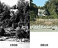 The rise of the Waiho River bed between 1936 and 2018
 -
 The Waiho Bridge was destroyed in 2019


See also
References
- ^ Te Rūnanga o Ngāi Tahu. "Whenua". Retrieved 14 June 2019.
- ^ Gorman, Paul; Guildford, Jonathan; Kitchin, Tom (26 March 2019). "State of emergency on West Coast as heavy rain batters region, wipes out bridge". Stuff. Retrieved 26 March 2019.
- ^ Guildford, Jonathan (2 May 2019). "West Coast's Waiho River bridge to close at night as final construction begins". The Press. p. 3. Retrieved 3 May 2019.
"Place name detail: Waiho River". New Zealand Gazetteer. New Zealand Geographic Board. Retrieved 12 July 2009.

Recent Comments