
Macanal is a town and municipality in the Colombian Department of Boyacá, part of the subregion of the Neira Province. The urban centre is located in the Tenza Valley in the Eastern Ranges of the Colombian Andes at an elevation of 1,680.3 metres (5,513 ft) but parts of the municipality reach elevations of 2,500 metres (8,200 ft). It borders Campohermoso in the east, Almeida in the west, Garagoa in the north and in the south Santa María and Chivor.[1]
Etymology
The name Macanal is either derived from the Chibcha word Macana, meaning garrote, or from the Macana palm tree (Wettinia kalbreyeri).[1][2]
History
The area of Macanal was part of the Muisca Confederation, a loose confederation of different rulers of the Muisca. The zaque of Hunza ruled over Macanal.
Modern Macanal was founded on May 4, 1807.[1]
Geology
The Macanal Formation, an organic shale, outcrops near and has been named after Macanal.
Economy
Main economical activities of Macanal are agriculture; coffee (Coffea arabica), bananas, maize, beans (Phaseolus vulgaris), yuca, sugarcane (Saccharum officinarum), arracacha (Arracacia xanthorrhiza), avocadoes, papayas, mangoes, guayaba and cucumbers (Cucumis sativus and Cyclanthera pedata), livestock farming and mining (gypsum and emeralds).[1]
Climate
| Climate data for Macanal (Inst Agr Macanal), elevation 1,300 m (4,300 ft), (1981–2010) | |||||||||||||
|---|---|---|---|---|---|---|---|---|---|---|---|---|---|
| Month | Jan | Feb | Mar | Apr | May | Jun | Jul | Aug | Sep | Oct | Nov | Dec | Year |
| Mean daily maximum °C (°F) | 23.5 (74.3) |
24.1 (75.4) |
23.5 (74.3) |
22.6 (72.7) |
21.9 (71.4) |
21.0 (69.8) |
20.5 (68.9) |
21.1 (70.0) |
22.1 (71.8) |
22.7 (72.9) |
22.3 (72.1) |
22.7 (72.9) |
22.2 (72.0) |
| Daily mean °C (°F) | 17.5 (63.5) |
17.8 (64.0) |
17.9 (64.2) |
17.7 (63.9) |
17.3 (63.1) |
16.6 (61.9) |
16.2 (61.2) |
16.4 (61.5) |
16.9 (62.4) |
17.4 (63.3) |
17.6 (63.7) |
17.4 (63.3) |
17.2 (63.0) |
| Mean daily minimum °C (°F) | 12.9 (55.2) |
13.4 (56.1) |
14.1 (57.4) |
14.6 (58.3) |
14.4 (57.9) |
13.9 (57.0) |
13.3 (55.9) |
13.3 (55.9) |
13.3 (55.9) |
13.6 (56.5) |
14.1 (57.4) |
13.5 (56.3) |
13.7 (56.7) |
| Average precipitation mm (inches) | 26.6 (1.05) |
64.2 (2.53) |
101.5 (4.00) |
191.5 (7.54) |
322.9 (12.71) |
367.9 (14.48) |
353.7 (13.93) |
293.6 (11.56) |
204.8 (8.06) |
160.4 (6.31) |
104.5 (4.11) |
48.5 (1.91) |
2,206.3 (86.86) |
| Average precipitation days (≥ 1.0 mm) | 9 | 11 | 16 | 24 | 27 | 28 | 29 | 28 | 24 | 22 | 20 | 14 | 246 |
| Average relative humidity (%) | 84 | 83 | 85 | 88 | 90 | 91 | 92 | 90 | 88 | 88 | 88 | 87 | 88 |
| Mean monthly sunshine hours | 182.9 | 144.0 | 120.9 | 96.0 | 96.1 | 81.0 | 86.8 | 93.0 | 120.0 | 142.6 | 144.0 | 173.6 | 1,480.9 |
| Mean daily sunshine hours | 5.9 | 5.1 | 3.9 | 3.2 | 3.1 | 2.7 | 2.8 | 3.0 | 4.0 | 4.6 | 4.8 | 5.6 | 4.1 |
| Source: Instituto de Hidrologia Meteorologia y Estudios Ambientales[3] | |||||||||||||
Gallery
-
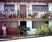 House in Macanal
 -
 Landscape around Macanal
 -
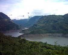 Artificial lake near Macanal


References
- ^ a b c d (in Spanish) Official website Macanal
- ^ (in Spanish) Etymology Municipalities Boyacá - Excelsio.net
- ^ "Promedios Climatológicos 1981–2010" (in Spanish). Instituto de Hidrologia Meteorologia y Estudios Ambientales. Archived from the original on 15 August 2016. Retrieved 3 June 2024.
| Gold |  | |
|---|---|---|
| Silver | ||
| Platinum | ||
| Nickel | ||
| Coltan | ||
| Emeralds | ||
| Coal | ||
| Salt | ||
| Sources | ||
| Geology |  | ||||
|---|---|---|---|---|---|
| History |
| ||||
| Main mining areas |
| ||||
| Individual mines |
| ||||
| Individual emeralds (ct) |
| ||||
| Related articles | |||||

Recent Comments