
| Year | Pop. | ±% |
|---|---|---|
| 1996 | 1,778,596 | — |
| 2006 | 1,879,385 | +5.7% |
| 2011 | 1,945,227 | +3.5% |
| 2016 | 1,952,434 | +0.4% |
| amar.org.ir | ||
Kermanshah province (Persian: استان كرمانشاه)[a] is one of the 31 provinces of Iran, bordering Iraq. Its capital is the city of Kermanshah.[9] According to a 2014 segmentation by the Ministry of Interior, it is the center of Region 4,[10] with the region's central secretariat located in Kermanshah. A majority of people in the province are Shia, and there are Sunni and Yarsani minority groups.[11][12][13]
At the time of the 2006 National Census, the population of Kermanshah province was 1,842,457 in 444,185 households.[14] By the time of the following census in 2011, there were 1,945,227 people in 530,911 households.[15] At the latest census in 2016, Kermanshah had a population of 1,952,434 in 576,861 households.[2]
Geography
Kermanshah province is located in western Iran. It shares borders with the provinces of Kurdistan, Hamadan, Lorestan, and Ilam within Iran.[16] It also shares borders with the Iraqi governorates of Halabja, Sulaymaniyah and Diyala.[17] Major cities and towns besides the capital include Eslamabad-e Gharb, Gilan-e Gharb, Harsin, Javanrud, Kangavar, Paveh, Qasr-e Shirin, Ravansar, Sahneh, Sarpol-e Zahab, and Sonqor.
Climate
As it is situated between two cold and warm regions, Kermanshah province enjoys a moderate and mountainous climate. It rains most in winter and is moderately warm in summer. The annual rainfall is 500 mm. The average temperature in the hottest months is above 22 °C.[citation needed]
History

The province has a rich Paleolithic heritage. Many caves with Paleolithic remains have been surveyed or excavated there. some of these cave sites are located in Bisetun and north of Kermanshah. The first known physical remains of Neanderthal man in Iran was discovered in Bisitun Cave. Do-Ashkaft Cave, Kobeh, Warwasi, and Mar Tarik are some of the Middle Paleolithic sites in the region. Kermanshah also has many Neolithic sites, of which the most well-known are Ganj Dareh, Sarab, and Asiab. At Ganj Dareh, the earliest evidence for goat domestication have been documented. In May 2009, based on a research conducted by the University of Hamedan and UCL, the head of Archeology Research Center of Iran's Cultural Heritage and Tourism Organization announced that the oldest prehistoric village in the Middle East dating back to 9800 B.C., was discovered in Sahneh, located in west of Kermanshah.[18][19]
The monuments found in Kermanshah show two glorious periods, the Achaemenid and Sassanid eras. The mythical ruler of the Pishdadian is described as founding the city while Tahmores Divband built it. An alternative narrative is that the construction was by Bahram IV of the Sassanid dynasty during the 4th century CE. Kermanshah reached a peak during the reign of Hormizd IV and Khosrau I of Sassanids, before being demoted to a secondary royal residence.
The city suffered major damage during the Arab invasions but recovered in the Safavid period to make great progress. Concurrent with the Afghan attack and the fall of Isfahan, Kermanshah was almost completely destroyed by the Ottoman invasion.
During the Iran–Iraq War the province suffered heavy fighting. Most towns and cities were badly damaged and some like Sar-e Pol-e Zahab and Qhasr-e-Shirin were almost completely destroyed.
The November 2017 Iran–Iraq earthquake killed more than 600 people.
On 28 December 2017, Kermanshah became one of several Iranian provinces to break out into protests. The Supreme Leader of Iran has blamed western interference. Some female organizations such as The National Council of Resistance of Iran (NCRI) have taken partial credit for the organization of these protests.[20][21]
Administrative divisions

The population history and structural changes of Kermanshah province's administrative divisions over three consecutive censuses are shown in the following table.
| Counties | 2006[14] | 2011[15] | 2016[2] |
|---|---|---|---|
| Dalahu | 42,310 | 39,837 | 35,987 |
| Eslamabad-e Gharb | 149,376 | 151,473 | 140,876 |
| Gilan-e Gharb | 60,671 | 62,858 | 57,007 |
| Harsin | 90,452 | 86,342 | 78,350 |
| Javanrud | 62,259 | 71,235 | 75,169 |
| Kangavar | 80,215 | 81,051 | 76,216 |
| Kermanshah | 950,400 | 1,030,978 | 1,083,833 |
| Paveh | 51,755 | 56,837 | 60,431 |
| Qasr-e Shirin | 19,821 | 25,517 | 23,929 |
| Ravansar | 44,983 | 46,395 | 47,657 |
| Sahneh | 75,827 | 76,678 | 70,757 |
| Salas-e Babajani | 37,056 | 38,475 | 35,219 |
| Sarpol-e Zahab | 81,428 | 85,616 | 85,342 |
| Sonqor | 95,904 | 91,935 | 81,661 |
| Total | 1,842,457 | 1,945,227 | 1,952,434 |
Cities
According to the 2016 census, 1,468,615 people (over 75% of the population of Kermanshah province) live in the following cities:[2]
| City | Population |
|---|---|
| Banevreh | 3,187 |
| Bayangan | 1,513 |
| Bisotun | 4,942 |
| Eslamabad-e Gharb | 90,559 |
| Ezgeleh | 1,502 |
| Gahvareh | 4,050 |
| Gilan-e Gharb | 22,331 |
| Gowdin | 2,629 |
| Halashi | 804 |
| Harsin | 44,146 |
| Homeyl | 1,317 |
| Javanrud | 54,354 |
| Kangavar | 51,352 |
| Kerend-e Gharb | 7,798 |
| Kermanshah | 946,651 |
| Kuzaran | 4,007 |
| Miyan Rahan | 695 |
| Nowdeshah | 3,683 |
| Nowsud | 1,949 |
| Paveh | 25,771 |
| Qasr-e Shirin | 18,473 |
| Ravansar | 24,527 |
| Robat | 823 |
| Sahneh | 35,508 |
| Sarmast | 2,913 |
| Sarpol-e Zahab | 45,481 |
| Satar | 1,048 |
| Shahrak-e Rijab | 3,907 |
| Shahu | 3,558 |
| Sonqor | 44,256 |
| Sumar | 180 |
| Tazehabad | 14,701 |
City of Kermanshah
The province's capital is Kermanshah, located in the middle of the western part of Iran. The population of the city is 946,651 as of 2016.[2] It is built on the slopes of Mt. Sefid Kooh and extended toward south during last two decades. The built-up areas run alongside Sarab River and Sarab Valley. The city's elevation averages about 1,350 meters above sea level.[citation needed]
The distance between Kermanshah and Tehran is 525 km. It is the trade center of rich agricultural region that produces grain, rice, vegetable, fruits, and oilseeds, and there are many industrial centers, oil and sugar refineries, and cement, textile and flour factories, etc. The airport (Shahid Ashrafi Esfahani Airport) is located in north east of the city, and the distance from Tehran is 413 km by air.
Economy
International and border trade
Kermanshah province has 371 km of common border with Iraq.There are five official border markets in the province. Three of these neighbor the Kurdish part of Iraq and the other two the Iraqi central government (Khosravi, Sumar). Based on figures from 9 November 2021, with a share of 5.7 to 6 percent Kermanshah province is among the first five exporters of non-oil products of Iran. Around 30 to 35 percent of theses exports were from the province's own products. The highest share of exports belong to Parviz border which neighbors Iraqi Kurdistan followed by Khosravi and Sumar.[22][23]
Exports from Kermanshah Province hit $2.7 billion in the fiscal year 2021-22 (ending 20 March), registering a 15% growth compared with the previous year, according to a local official.
The province's share in Iran's total exports during the period stood at 10% in terms of tonnage and 12% in value.
Kermanshah's share in total exports to Iraq stood at 53% and share in non-oil goods reached 43%.
Non-oil exports from Kermanshah mainly include tomato and tomato paste, air conditioners, cheese, industrial oil and their derivatives, biscuit, different types of melon, watermelon, tile and ceramic, plastic bags, marble, yogurt, milk, cream, cucumber, eggplant, apple and melamine dishes.[23]
Local products
Kermanshah lends its name to a type of Persian carpet named after the region. It also has famous sweets made of rice, locally known as Nan-e berenji.[24] The other famous Kermanshahi good is a special kind of oil, locally known as Rüne Dân and globally in Iran known as Roghan Kermanshahi. The Giveh of Kermanshah known as Klash is the highest quality Giveh.
Historical attractions
Various attractions exist that date from the pre-Islamic era, such as the Kohneh Bridge, to contemporary parks and museums. Some of the more popular sites are:
- Bisotun:
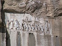
Darius the Great's Behistun inscription

- Darius the Great's inscription at Bisotun, which dates to 522 BCE, lies some 1300 meters high in the mountains, and counts as one of the most famous sites in Near Eastern archeology. The site is a UNESCO World Heritage Site,[25] and has been attracting visitors for centuries. The Behistun inscription is to Old Persian cuneiform what the Rosetta Stone is to Egyptian hieroglyphs: the trilingual inscription (in Old Persian, Elamite and Akkadian) was crucial in the decipherment of the script. The relief above the inscription depicts Darius facing nine rebels who objected to his crowning. At the king's feet lies Gaumata. The location of this important historical document is not coincidental: Gaumata, a usurper who is depicted as lying at Darius' feet, was a Medean and in Achaemenid times Behistun lay on the Medea-Parsa highway.

- Behistun is also notable for three reliefs at the foot of the hill that date from the Parthian era. Among them is a Hellenistic-era depiction of the divinity Bahram as the Greek hero Hercules, who reclines with a goblet in his hand, a club at his feet and a lion-skin beneath him. Because it lies on the route of an ancient highway, this life-size rock sculpture may reflect Bahram's status as patron divinity of travelers.
- The rock reliefs at Taq-e Bostan lie 6 kilometres (4 mi) northeast of Kermanshah, where a spring gushes from a mountain cliff and empties into a large reflecting pool. One of the more impressive reliefs, inside the largest grotto (ivan), is the oversized depiction of Sassanid king Khosrau II (591–628 CE), who appears mounted on his favorite charger, Shabdiz. Both the horse and the rider are arrayed in full battle armor.
- There are two hunting scenes on complementary sides of the ivan: one depicts an imperial boar hunt and the other depicting the king stalking deer. Elephants flush out the boar from a marshy lake for the king who stands poised with bow and arrow in hand while he is serenaded by female musicians following in other boats. These royal hunting scenes are narrative murals in stone are count among the most vivid of all Iranian rock reliefs.
- The Taq-e Bostan reliefs are not limited to the Sassanid era. An upper relief depicts the 19th century Qajar king Fath-Ali shah holding court.
- The Kangavar archaeological complex:
- Kangavar is the site of the archaeological remains of a vast Hellenic-style edifice on a raised platform. The visible remains at the site date to early Sassanid times,[26] but the platform of the complex may be several centuries older. By the time excavation began in 1968, the complex had been preemptorily associated with a comment by Isidore of Charax who referred to a temple of Anahita at Concobar (the Greek name of Kangavar, which was then in Lower Medea). Despite archaeological findings to the contrary,[26] the association with the divinity of fertility, healing, and wisdom has made the site a popular tourist attraction. The vast edifice was built of enormous blocks of dressed stone with an imposing entrance of opposed staircases that may have been inspired by the Apadana in Persepolis.[27]
Anthropology
Kermanshah province is one of those provinces of Iran where different ethnic and religious groups live. Kurds, Persian speakers, Lurs, Arabs are among the most important ethnic groups that live in this province. Another anthropological feature of this province is the presence of followers of different religions such as Shiites, Sunnis and Yarsans in this province.[27][28][29]
Higher education
Higher education and research
- Kermanshah University of Medical Sciences[30]
- Razi University[31]
- Islamic Azad University of Kermanshah[32]
Notable people

One of the renowned scientists and writers of this region is Al-Dinawari who was born at Dinawar north-east of Kermanshah. He lived in the 9th century and has written many books in astronomy, botany and history. Notable people born in Kermansha include British author, Nobel prize winner, Doris Lessing, whose father, a British Army officer, was stationed there at the time of her birth. Mirza Ahmad Khan Motazed-Dowleh Vaziri created the first printing office and founded the first private school of Kermanshahan. Guity Novin a painter and a graphic designer who has founded the Transpressionism movement was born in Kermanshah. The famous Sufi Scholar, Abdul Qader Gailani, was born in the region.
See also
![]() Media related to Kermanshah Province at Wikimedia Commons
Media related to Kermanshah Province at Wikimedia Commons
Notes
References
- ^ OpenStreetMap contributors (23 May 2024). "Kermanshah Province" (Map). OpenStreetMap. Retrieved 23 May 2024.
- ^ a b c d e "Census of the Islamic Republic of Iran, 1395 (2016)". AMAR (in Persian). The Statistical Center of Iran. p. 05. Archived from the original (Excel) on 3 April 2022. Retrieved 19 December 2022.
- ^ "Welcome to Encyclopaedia Iranica".
- ^ Borjian, Habib (2017). "KERMANSHAH vii. Languages and Dialects". 16: 327–331. doi:10.7916/D8DJ6T5Q.
{{cite journal}}: Cite journal requires|journal=(help) - ^ "Sub-national HDI - Area Database - Global Data Lab". hdi.globaldatalab.org. Retrieved 13 September 2018.
- ^ "Li Kirmaşan erdhej" (in Kurdish). 1 October 2018. Archived from the original on 13 June 2020. Retrieved 18 March 2020.
- ^ "بەرپرسانی ڕێژیم بەڵێنی درۆ و بێ بنەما بە خەڵکی لێقەوماوی پارێزگای کرماشان دەدەن" (in Kurdish). Retrieved 18 March 2020.
- ^ Natiq Nouri, Ali Akbar (8 February 1372). "Law on changing the name of Bakhtaran province to Kermanshah". Research Center of the System of Laws of the Islamic Council of Farabi Mobile Library (in Persian). Shura Council. Archived from the original on 27 January 2013. Retrieved 5 March 2024.
- ^ Habibi, Hassan (21 June 1369). "Approval of the organization and chain of citizenship of the elements and units of the national divisions of Bakhtran province, centered in the city of Bakhtran". Research Center of the System of Laws of the Islamic Council of Farabi Mobile Library (in Persian). Ministry of Interior, Defense Political Commission of the Government Board. Archived from the original on 6 February 2013. Retrieved 29 January 2024.
- ^ "همشهری آنلاین-استانهای کشور به ۵ منطقه تقسیم شدند (Provinces were divided into 5 regions)". Hamshahri Online (in Persian). 22 June 2014. Archived from the original on 23 June 2014.
- ^ www.justice.gov/sites/default/files
- ^ "artkermanshah.ir". Archived from the original on 29 September 2018. Retrieved 16 July 2017.
- ^ "Ahmady, Kameel. A Peace-Oriented Investigation of the Ethnic Identity Challenge in Iran (A Study of Five Iranian Ethnic Groups with the GT Method), 2022, 13th Eurasian Conferences on Language and Social Sciences pp. 591–624". 13th Eurasian Conferences on Language and Social Sciences.
- ^ a b "Census of the Islamic Republic of Iran, 1385 (2006)". AMAR (in Persian). The Statistical Center of Iran. p. 05. Archived from the original (Excel) on 20 September 2011. Retrieved 25 September 2022.
- ^ a b "Census of the Islamic Republic of Iran, 1390 (2011)". Syracuse University (in Persian). The Statistical Center of Iran. p. 05. Archived from the original (Excel) on 18 January 2023. Retrieved 19 December 2022.
- ^ "Kermanshah Province".
- ^ "معرفی استان دیالی". Archived from the original on 20 November 2022. Retrieved 20 November 2022.
- ^ "Most ancient Mid East village discovered in western Iran". 2009. Archived from the original on 1 February 2010. Retrieved 23 May 2009.
- ^ "با 11800 سال قدمت، قديميترين روستاي خاورميانه در كرمانشاه كشف شد". 2009. Retrieved 23 May 2009. [dead link]
- ^ "Iran: Women keep high the spirit of nationwide protests" Archived 14 January 2018 at the Wayback Machine, The National Council of Resistance of Iran
- ^ "Ahmady, Kameel. Investigation of the Ethnic Identity Challenge in Iran- A Peace-Oriented". Efflatounia. 5 (2): 3242–3270. 2021.
- ^ "کرمانشاه جزو 5 استان اول ایران از نظر صادرات غیرنفتی است". 9 November 2021.
- ^ a b "With $2.7b, Kermanshah Accounts for 12% of Iran's Goods Export". 26 April 2022.
- ^ "طرز تهیه شیرینی نان برنجی خوشمزه مرحله به مرحله". 9 February 2022.
- ^ CHN Press release (2006). "Iran's Bisotoon Historical Site Registered in World Heritage List".
- ^ a b Kleiss, Wolfram (2005). "Kangavar". Encyclopedia Iranica. Costa Mesa: Mazda.
- ^ a b Ahmady, Kameel 2019: From Border to Border. Comprehensive research study on identity and ethnicity in Iran. Mehri publication, London.
- ^ KUMS. "About Kermanshah". KUMS. Retrieved 6 October 2023.
- ^ "Kermanshah, Iran Metro Area Population 1950-2023". macrotrends.net. Retrieved 6 October 2023.
- ^ "Home". kums.ac.ir.
- ^ "Home". razi.ac.ir.
- ^ "Home". en.iauksh.ac.ir. Archived from the original on 18 January 2022. Retrieved 8 August 2022.
Sources
- Borijan, Habib (2015). "KERMANSHAH i. Geography". Encyclopaedia Iranica.
- Borijan, Habib (2016). "KERMANSHAH vii. Languages and Dialects". Encyclopaedia Iranica.
- Calmard, Jean (2015). "KERMANSHAH iv. History from the Arab Conquest to 1953". Encyclopaedia Iranica.
- Pirnazar, Nahid (2014). "KERMANSHAH viii. The Jewish Community". Encyclopaedia Iranica.
Bibliography
- Ahmady, Kameel (2023). From Border to Border. Moldova: Scholars' Press publishes. ISBN 9786206769538.
External links
- Kirmashan website, Kurdish Culture
- Yarsan
- A Persian article about Giveh Archived 27 September 2007 at the Wayback Machine
Places adjacent to Kermanshah province | ||||||||||||||||
|---|---|---|---|---|---|---|---|---|---|---|---|---|---|---|---|---|
| ||||||||||||||||
| National | |
|---|---|
| Geographic | |
Kermanshah Province, Iran | ||
|---|---|---|
| Capital |  | |
| Counties and cities | ||
| Sights |
| |
| populated places | ||

Recent Comments