How Can We Help?
You are here:
< Back
Size of this preview: 800 × 162 pixels. Other resolutions: 320 × 65 pixels | 640 × 130 pixels | 1,024 × 208 pixels | 1,280 × 259 pixels | 5,328 × 1,080 pixels.
Original file (5,328 × 1,080 pixels, file size: 2.25 MB, MIME type: image/jpeg)
Summary
DescriptionView from Nagahama-castle.JPG |
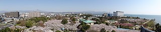
English: View from Nagahama-jo castle,Shiga Pref., Japan
日本語: 長浜城からの展望、滋賀県、日本 |
Date | |
Source | Own work |
Author | アラツク |
Camera location | 35° 22′ 39.4″ N, 136° 15′ 40.7″ E | View this and other nearby images on: OpenStreetMap | 35.377611; 136.261306 |
---|
Licensing
I, the copyright holder of this work, hereby publish it under the following licenses:
Permission is granted to copy, distribute and/or modify this document under the terms of the GNU Free Documentation License, Version 1.2 or any later version published by the Free Software Foundation; with no Invariant Sections, no Front-Cover Texts, and no Back-Cover Texts. A copy of the license is included in the section entitled GNU Free Documentation License.http://www.gnu.org/copyleft/fdl.htmlGFDLGNU Free Documentation Licensetruetrue |
This file is licensed under the Creative Commons Attribution-Share Alike Attribution-Share Alike 4.0 International, 3.0 Unported, 2.5 Generic, 2.0 Generic and 1.0 Generic license.
- You are free:
- to share – to copy, distribute and transmit the work
- to remix – to adapt the work
- Under the following conditions:
- attribution – You must give appropriate credit, provide a link to the license, and indicate if changes were made. You may do so in any reasonable manner, but not in any way that suggests the licensor endorses you or your use.
- share alike – If you remix, transform, or build upon the material, you must distribute your contributions under the same or compatible license as the original.
You may select the license of your choice.
Items portrayed in this file
depicts
copyright status
copyrighted
copyright license
Creative Commons Attribution-ShareAlike 1.0 Generic
Creative Commons Attribution-ShareAlike 3.0 Unported
Creative Commons Attribution-ShareAlike 4.0 International
Creative Commons Attribution-ShareAlike 2.5 Generic
GNU Free Documentation License, version 1.2 or later
Creative Commons Attribution-ShareAlike 2.0 Generic
captured with
Sony Cyber-shot DSC-HX5V
source of file
original creation by uploader
inception
12 April 2011
exposure time
0.001 second
f-number
3.5
focal length
4.25 millimetre
ISO speed
125
instance of
photograph
media type
image/jpeg
checksum
cef40c0a09b47f2b3f4b65e51e279059446d0e66
determination method: SHA-1
data size
2,360,433 byte
height
1,080 pixel
width
5,328 pixel
coordinates of the point of view
35°22'39.400"N, 136°15'40.702"E
heading: 137.75 degree
File history
Click on a date/time to view the file as it appeared at that time.
Date/Time | Thumbnail | Dimensions | User | Comment | |
---|---|---|---|---|---|
current | 11:48, 1 May 2011 | 5,328 × 1,080 (2.25 MB) | アラツク | {{Information |Description={{en|1=View from Nagahama-jo castle,Shiga Pref., Japan}} {{ja|1=長浜城からの展望、滋賀県、日本}} |Source={{own}} |Author=アラツク |Date= 2011-04-12 |Permission= |other_versions= }} {{Location|35|22|39.4|N|136 |
File usage
The following pages on the English Wikipedia use this file (pages on other projects are not listed):
Global file usage
The following other wikis use this file:
- Usage on ja.wikipedia.org
- Usage on ro.wikipedia.org
- Usage on www.wikidata.org
Metadata
This file contains additional information, probably added from the digital camera or scanner used to create or digitize it.
If the file has been modified from its original state, some details may not fully reflect the modified file.
Camera manufacturer | SONY |
---|---|
Camera model | DSC-HX5V |
Exposure time | 1/1,000 sec (0.001) |
F-number | f/3.5 |
ISO speed rating | 125 |
Date and time of data generation | 14:39, 12 April 2011 |
Lens focal length | 4.25 mm |
Altitude | 113.6 meters above sea level |
Orientation | Normal |
Horizontal resolution | 72 dpi |
Vertical resolution | 72 dpi |
Software used | PMB |
File change date and time | 22:26, 20 April 2011 |
Y and C positioning | Co-sited |
Exposure Program | Normal program |
Exif version | 2.3 |
Date and time of digitizing | 14:39, 12 April 2011 |
Image compression mode | 4 |
Exposure bias | 0 |
Maximum land aperture | 3.625 APEX (f/3.51) |
Metering mode | Pattern |
Light source | Unknown |
Flash | Flash did not fire, compulsory flash suppression |
Color space | sRGB |
Custom image processing | Normal process |
Exposure mode | Auto exposure |
White balance | Auto white balance |
Scene capture type | Standard |
Contrast | Normal |
Saturation | Normal |
Sharpness | Normal |
North or south latitude | North latitude |
East or west longitude | East longitude |
Receiver status | Measurement interoperability |
Measurement mode | 3-dimensional measurement |
Speed unit | Kilometers per hour |
Speed of GPS receiver | 0.6 |
Reference for direction of movement | True direction |
Direction of movement | 10.74 |
Reference for direction of image | Magnetic direction |
Direction of image | 137.75 |
Geodetic survey data used | WGS-84 |
GPS date | 12 April 2011 |
GPS differential correction | 0 |
Categories
-
Annuals36
-
Bulbs, Corms & Tubers41
-
Ferns27
-
Fruits3
-
Garden Plants23
-
Grasses26
-
Herb17
-
Insects1
-
Mammals1
-
Midwest Native Plants0
-
Northeast Native Plants112
-
Perennials123
-
Rose1
-
Shrubs47
-
Trees112
-
Tropical Plants53
-
Upland Birds5
-
Vines18
-
Viola Tricolor1
-
Water Gardening & Plants9
-
Waterfowl0
-
Wetland Birds0
-
Wetland Plants4
-
Wildbirds172
-
Wildflowers1
-
Woodland Plants29
Table of Contents
Recent Comments