How Can We Help?
You are here:
< Back
Valley_of_Bervie_Water_-_geograph.org.uk_-_498820.jpg (640 × 480 pixels, file size: 110 KB, MIME type: image/jpeg)
Summary
DescriptionValley of Bervie Water - geograph.org.uk - 498820.jpg |
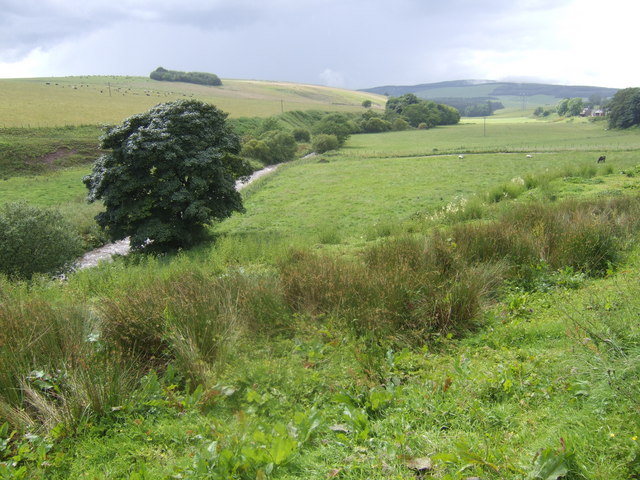
English: Valley of Bervie Water The burn is well up with storm flow from the previous days heavy rain - more was to come later! |
Date | |
Source | From geograph.org.uk |
Author | Jonathan Billinger |
Attribution (required by the license) InfoField | Jonathan Billinger / Valley of Bervie Water / |
InfoField | Jonathan Billinger / Valley of Bervie Water |
Camera location | 56° 55′ 22″ N, 2° 25′ 00″ W | View this and other nearby images on: OpenStreetMap | 56.922720; -2.416800 |
---|
Object location | 56° 55′ 22″ N, 2° 25′ 22″ W | View this and other nearby images on: OpenStreetMap | 56.922700; -2.422700 |
---|
Licensing
This image was taken from the Geograph project collection. See this photograph's page on the Geograph website for the photographer's contact details. The copyright on this image is owned by Jonathan Billinger and is licensed for reuse under the Creative Commons Attribution-ShareAlike 2.0 license.
|
This file is licensed under the Creative Commons Attribution-Share Alike 2.0 Generic license.
Attribution: Jonathan Billinger
- You are free:
- to share – to copy, distribute and transmit the work
- to remix – to adapt the work
- Under the following conditions:
- attribution – You must give appropriate credit, provide a link to the license, and indicate if changes were made. You may do so in any reasonable manner, but not in any way that suggests the licensor endorses you or your use.
- share alike – If you remix, transform, or build upon the material, you must distribute your contributions under the same or compatible license as the original.
Items portrayed in this file
depicts
creator
some value
author name string: Jonathan Billinger
object has role: photographer
copyright status
copyrighted
copyright license
Creative Commons Attribution-ShareAlike 2.0 Generic
source of file
file available on the internet
operator: Geograph Britain and Ireland
described at URL: https://www.geograph.org.uk/photo/498820
geograph.org.uk image ID: 498820
inception
17 July 2007
coordinates of the point of view
56°55'21.79"N, 2°25'0.48"W
heading: 270 degree
coordinates of depicted place
56°55'21.72"N, 2°25'21.72"W
heading: 270 degree
exposure time
0.00222222222222222222 second
f-number
2.8
focal length
7.2 millimetre
ISO speed
100
media type
image/jpeg
instance of
photograph
File history
Click on a date/time to view the file as it appeared at that time.
Date/Time | Thumbnail | Dimensions | User | Comment | |
---|---|---|---|---|---|
current | 06:31, 5 February 2011 | 640 × 480 (110 KB) | GeographBot | == {{int:filedesc}} == {{Information |description={{en|1=Valley of Bervie Water The burn is well up with storm flow from the previous days heavy rain - more was to come later!}} |date=2007-07-17 |source=From [http://www.geograph.org.uk/photo/498820 geogra |
File usage
The following pages on the English Wikipedia use this file (pages on other projects are not listed):
Global file usage
The following other wikis use this file:
- Usage on it.wikipedia.org
- Usage on ru.wikipedia.org
Metadata
This file contains additional information, probably added from the digital camera or scanner used to create or digitize it.
If the file has been modified from its original state, some details may not fully reflect the modified file.
Camera manufacturer | FUJIFILM |
---|---|
Camera model | FinePix E900 |
Exposure time | 1/450 sec (0.0022222222222222) |
F-number | f/2.8 |
ISO speed rating | 100 |
Date and time of data generation | 15:10, 17 July 2007 |
Lens focal length | 7.2 mm |
Orientation | Normal |
Horizontal resolution | 72 dpi |
Vertical resolution | 72 dpi |
Software used | Digital Camera FinePix E900 Ver1.00 |
File change date and time | 15:10, 17 July 2007 |
Y and C positioning | Co-sited |
Exposure Program | Normal program |
Exif version | 2.2 |
Date and time of digitizing | 15:10, 17 July 2007 |
Image compression mode | 2 |
Shutter speed | 8.89 |
APEX aperture | 3 |
APEX brightness | 6.86 |
Exposure bias | 0 |
Maximum land aperture | 3 APEX (f/2.83) |
Metering mode | Pattern |
Light source | Unknown |
Flash | Flash did not fire, compulsory flash suppression |
Color space | sRGB |
Focal plane X resolution | 4,482 |
Focal plane Y resolution | 4,482 |
Focal plane resolution unit | 3 |
Sensing method | One-chip color area sensor |
Custom image processing | Normal process |
Exposure mode | Auto exposure |
White balance | Auto white balance |
Scene capture type | Standard |
Sharpness | 3 |
Subject distance range | Unknown |
Categories
-
Annuals36
-
Bulbs, Corms & Tubers41
-
Ferns27
-
Fruits3
-
Garden Plants23
-
Grasses26
-
Herb17
-
Insects1
-
Mammals1
-
Midwest Native Plants0
-
Northeast Native Plants112
-
Perennials123
-
Rose1
-
Shrubs47
-
Trees112
-
Tropical Plants53
-
Upland Birds5
-
Vines18
-
Viola Tricolor1
-
Water Gardening & Plants9
-
Waterfowl0
-
Wetland Birds0
-
Wetland Plants4
-
Wildbirds172
-
Wildflowers1
-
Woodland Plants29
Table of Contents
Recent Comments