How Can We Help?
You are here:
< Back
![File:Txu-pclmaps-oclc-22834566 e-9c.jpg](https://upload.wikimedia.org/wikipedia/commons/thumb/3/39/Txu-pclmaps-oclc-22834566_e-9c.jpg/800px-Txu-pclmaps-oclc-22834566_e-9c.jpg)
Size of this preview: 800 × 581 pixels. Other resolutions: 320 × 233 pixels | 640 × 465 pixels | 1,024 × 744 pixels | 1,280 × 930 pixels | 2,560 × 1,860 pixels | 9,377 × 6,814 pixels.
Original file (9,377 × 6,814 pixels, file size: 22.9 MB, MIME type: image/jpeg)
Summary
DescriptionTxu-pclmaps-oclc-22834566 e-9c.jpg |
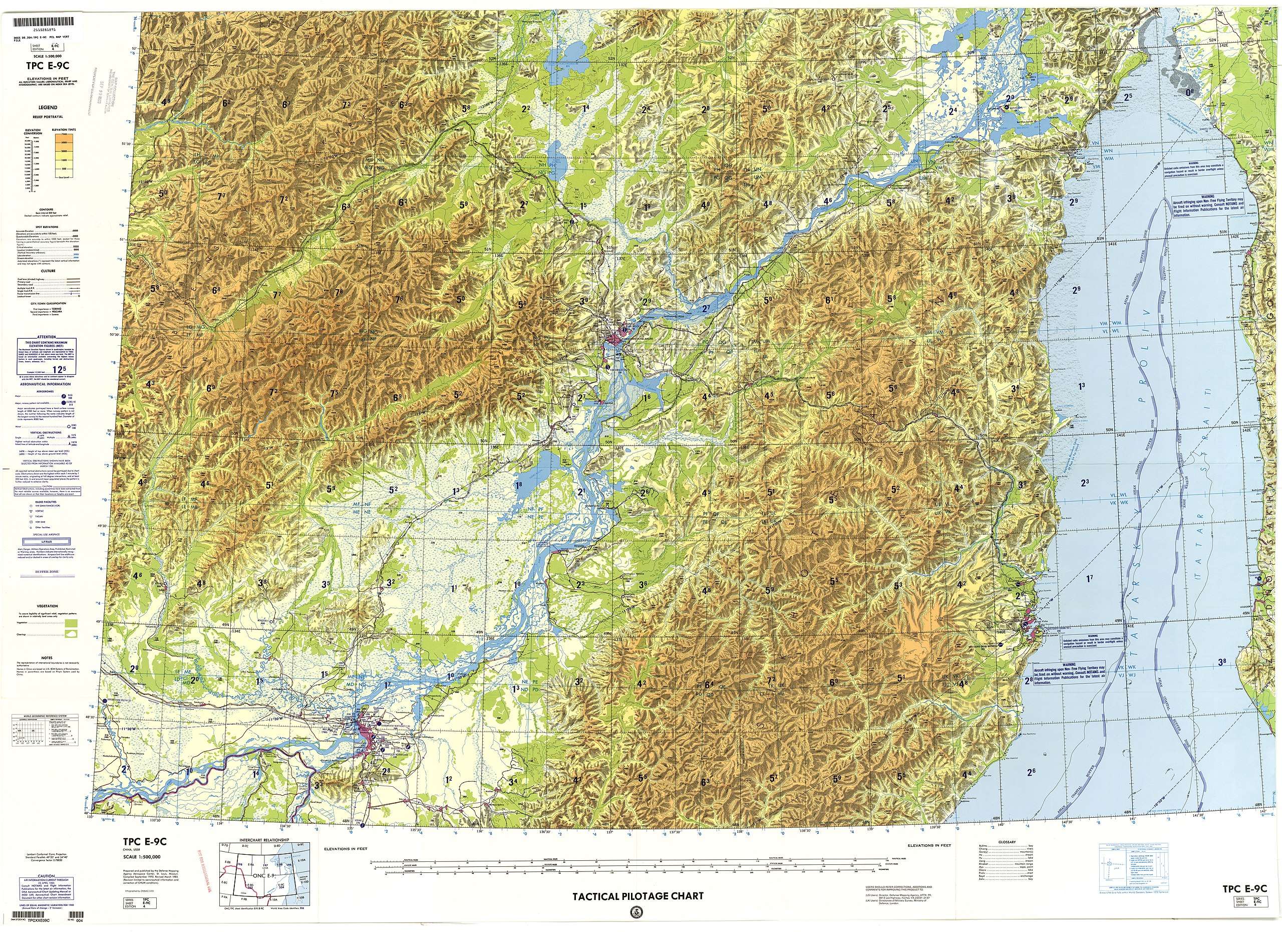
English: Tactical Pilotage Chart Series - World 1:500,000 Scale |
Date | |
Source | |
Author | Defense Mapping Agency |
Licensing
Public domainPublic domainfalsefalse |
![]() |
This work is in the public domain in the United States because it is a work prepared by an officer or employee of the United States Government as part of that person’s official duties under the terms of Title 17, Chapter 1, Section 105 of the US Code.
Note: This only applies to original works of the Federal Government and not to the work of any individual U.S. state, territory, commonwealth, county, municipality, or any other subdivision. This template also does not apply to postage stamp designs published by the United States Postal Service since 1978. (See § 313.6(C)(1) of Compendium of U.S. Copyright Office Practices). It also does not apply to certain US coins; see The US Mint Terms of Use.
|
![]() |
This file has been identified as being free of known restrictions under copyright law, including all related and neighboring rights. |
https://creativecommons.org/publicdomain/mark/1.0/PDMCreative Commons Public Domain Mark 1.0falsefalse
Captions
Add a one-line explanation of what this file represents
Items portrayed in this file
depicts
copyright status
public domain
media type
image/jpeg
File history
Click on a date/time to view the file as it appeared at that time.
Date/Time | Thumbnail | Dimensions | User | Comment | |
---|---|---|---|---|---|
current | 09:03, 27 December 2019 | ![]() | 9,377 × 6,814 (22.9 MB) | Geographyinitiative | User created page with UploadWizard |
File usage
The following pages on the English Wikipedia use this file (pages on other projects are not listed):
Metadata
This file contains additional information, probably added from the digital camera or scanner used to create or digitize it.
If the file has been modified from its original state, some details may not fully reflect the modified file.
Camera manufacturer | i2s Digibook Scanner |
---|---|
Camera model | Suprascan A0 10000 RGB |
Width | 10,096 px |
Height | 17,950 px |
Bits per component |
|
Compression scheme | Uncompressed |
Pixel composition | RGB |
Orientation | Normal |
Number of components | 3 |
Horizontal resolution | 300 dpi |
Vertical resolution | 300 dpi |
Data arrangement | chunky format |
Software used | Adobe Photoshop CS5 Macintosh |
File change date and time | 19:19, 16 November 2011 |
Exif version | 2.21 |
Color space | Uncalibrated |
Date and time of digitizing | 06:26, 30 August 2011 |
Date metadata was last modified | 13:19, 16 November 2011 |
Unique ID of original document | xmp.did:10093C0C24DEE0119875FECB9D0F9A0C |
Categories
-
Annuals36
-
Bulbs, Corms & Tubers41
-
Ferns27
-
Fruits3
-
Garden Plants23
-
Grasses26
-
Herb17
-
Insects1
-
Mammals1
-
Midwest Native Plants0
-
Northeast Native Plants112
-
Perennials123
-
Rose1
-
Shrubs47
-
Trees112
-
Tropical Plants53
-
Upland Birds5
-
Vines18
-
Viola Tricolor1
-
Water Gardening & Plants9
-
Waterfowl0
-
Wetland Birds0
-
Wetland Plants4
-
Wildbirds172
-
Wildflowers1
-
Woodland Plants29
Table of Contents
Recent Comments