![File:Tumulo II del sodo, piattaforma d'altare per le cerimonie funebri, 600 ac ca. 08.jpg](https://upload.wikimedia.org/wikipedia/commons/thumb/e/e4/Tumulo_II_del_sodo%2C_piattaforma_d%27altare_per_le_cerimonie_funebri%2C_600_ac_ca._08.jpg/800px-Tumulo_II_del_sodo%2C_piattaforma_d%27altare_per_le_cerimonie_funebri%2C_600_ac_ca._08.jpg)
Original file (5,664 × 4,160 pixels, file size: 14.42 MB, MIME type: image/jpeg)
Summary
DescriptionTumulo II del sodo, piattaforma d'altare per le cerimonie funebri, 600 ac ca. 08.jpg |
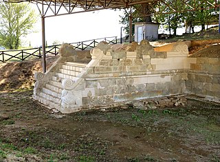
Italiano: area archeologica del Sodo e Tomba di Camucia
|
||
Date | |||
Source | Own work | ||
Author | Sailko |
Camera location | 43° 16′ 51.99″ N, 11° 57′ 59.81″ E ![]() | View this and other nearby images on: OpenStreetMap | ![]() |
---|
Licensing
![w:en:Creative Commons](https://upload.wikimedia.org/wikipedia/commons/thumb/7/79/CC_some_rights_reserved.svg/90px-CC_some_rights_reserved.svg.png)
![attribution](https://upload.wikimedia.org/wikipedia/commons/thumb/1/11/Cc-by_new_white.svg/24px-Cc-by_new_white.svg.png)
![share alike](https://upload.wikimedia.org/wikipedia/commons/thumb/d/df/Cc-sa_white.svg/24px-Cc-sa_white.svg.png)
- You are free:
- to share – to copy, distribute and transmit the work
- to remix – to adapt the work
- Under the following conditions:
- attribution – You must give appropriate credit, provide a link to the license, and indicate if changes were made. You may do so in any reasonable manner, but not in any way that suggests the licensor endorses you or your use.
- share alike – If you remix, transform, or build upon the material, you must distribute your contributions under the same or compatible license as the original.
![]() |
This image was uploaded as part of Wiki Loves Monuments 2020.
Afrikaans ∙ Alemannisch ∙ azərbaycanca ∙ Bahasa Indonesia ∙ Bahasa Melayu ∙ Bikol Central ∙ bosanski ∙ brezhoneg ∙ català ∙ čeština ∙ Cymraeg ∙ dansk ∙ davvisámegiella ∙ Deutsch ∙ eesti ∙ English ∙ español ∙ Esperanto ∙ euskara ∙ français ∙ Frysk ∙ Gaeilge ∙ galego ∙ hrvatski ∙ Ido ∙ italiano ∙ latviešu ∙ Lëtzebuergesch ∙ Malagasy ∙ magyar ∙ Malti ∙ Nederlands ∙ norsk ∙ norsk nynorsk ∙ norsk bokmål ∙ polski ∙ português ∙ português do Brasil ∙ română ∙ shqip ∙ sicilianu ∙ slovenčina ∙ slovenščina ∙ suomi ∙ svenska ∙ Tagalog ∙ Türkçe ∙ Yorùbá ∙ Zazaki ∙ Ελληνικά ∙ беларуская ∙ беларуская (тарашкевіца) ∙ български ∙ кыргызча ∙ македонски ∙ русский ∙ српски / srpski ∙ українська ∙ ქართული ∙ հայերեն ∙ नेपाली ∙ हिन्दी ∙ বাংলা ∙ മലയാളം ∙ ไทย ∙ 한국어 ∙ |
![]() |
![]() |
The making of this document was supported by Wikimedia CH. (Submit your project!) For all the files concerned, please see the category Supported by Wikimedia CH. العربية ∙ বাংলা ∙ čeština ∙ Deutsch ∙ English ∙ Esperanto ∙ español ∙ français ∙ galego ∙ magyar ∙ italiano ∙ 日本語 ∙ македонски ∙ Nederlands ∙ português do Brasil ∙ rumantsch ∙ русский ∙ sicilianu ∙ slovenščina ∙ українська ∙ தமிழ் ∙
|
Captions
Items portrayed in this file
depicts
Sodo archaeologic area and Camucia's tomb
creator
some value
copyright status
copyrighted
copyright license
Creative Commons Attribution-ShareAlike 4.0 International
source of file
original creation by uploader
inception
5 September 2020
coordinates of the point of view
43°16'51.989"N, 11°57'59.814"E
sponsor
Wikimedia CH
participant in
Wiki Loves Monuments 2020
Wiki Loves Monuments 2020 in Italy
location of creation
Cortona
File history
Click on a date/time to view the file as it appeared at that time.
Date/Time | Thumbnail | Dimensions | User | Comment | |
---|---|---|---|---|---|
current | 14:09, 29 September 2020 | ![]() | 5,664 × 4,160 (14.42 MB) | Sailko | Uploaded own work with UploadWizard |
File usage
Global file usage
The following other wikis use this file:
- Usage on it.wikipedia.org
- Progetto:Wiki Loves Monuments 2018/Monumenti/Toscana/Provincia di Arezzo
- Progetto:Wiki Loves Monuments 2019/Monumenti/Toscana/Provincia di Arezzo
- Progetto:Wiki Loves Monuments 2020/Monumenti/Toscana/Provincia di Arezzo
- Area archeologica del Sodo
- Progetto:Wiki Loves Monuments 2021/Monumenti/Toscana/Provincia di Arezzo
- Progetto:Wiki Loves Monuments 2022/Monumenti/Toscana/Provincia di Arezzo
- Progetto:Musei/Liste/Toscana
- Usage on www.wikidata.org
Metadata
This file contains additional information, probably added from the digital camera or scanner used to create or digitize it.
If the file has been modified from its original state, some details may not fully reflect the modified file.
Camera manufacturer | Canon |
---|---|
Camera model | Canon EOS 6D Mark II |
Exposure time | 1/100 sec (0.01) |
F-number | f/4.5 |
ISO speed rating | 100 |
Date and time of data generation | 14:51, 5 September 2020 |
Lens focal length | 40 mm |
Latitude | 43° 16′ 51.99″ N |
Longitude | 11° 57′ 59.81″ E |
Altitude | 310.8 meters above sea level |
Width | 6,240 px |
Height | 4,160 px |
Bits per component |
|
Pixel composition | RGB |
Orientation | Normal |
Number of components | 3 |
Horizontal resolution | 72 dpi |
Vertical resolution | 72 dpi |
Software used | Adobe Photoshop CC 2017 (Windows) |
File change date and time | 13:51, 29 September 2020 |
Y and C positioning | Co-sited |
Exposure Program | Normal program |
Exif version | 2.3 |
Date and time of digitizing | 14:51, 5 September 2020 |
Meaning of each component |
|
Shutter speed | 6.625 |
APEX aperture | 4.375 |
Exposure bias | 0 |
Maximum land aperture | 4.125 APEX (f/4.18) |
Metering mode | Pattern |
Flash | Flash did not fire, compulsory flash suppression |
DateTime subseconds | 57 |
DateTimeOriginal subseconds | 57 |
DateTimeDigitized subseconds | 57 |
Supported Flashpix version | 1 |
Color space | sRGB |
Focal plane X resolution | 6,673.7967914439 |
Focal plane Y resolution | 6,720.5169628433 |
Focal plane resolution unit | inches |
Custom image processing | Normal process |
Exposure mode | Auto exposure |
White balance | Auto white balance |
Scene capture type | Standard |
GPS time (atomic clock) | 13:51:1.432 |
Satellites used for measurement | 6 |
Receiver status | Measurement in progress |
Measurement mode | 3-dimensional measurement |
Measurement precision | Poor (2.2) |
Geodetic survey data used | WGS-84 |
GPS date | 5 September 2020 |
GPS tag version | 0.0.3.2 |
Serial number of camera | 313052000773 |
Lens used | EF24-105mm f/3.5-5.6 IS STM |
Rating (out of 5) | 0 |
Date metadata was last modified | 15:51, 29 September 2020 |
Unique ID of original document | 97DD1DD3A5AE9A65C352872701345CF3 |
-
Annuals36
-
Bulbs, Corms & Tubers41
-
Ferns27
-
Fruits3
-
Garden Plants23
-
Grasses26
-
Herb17
-
Insects1
-
Mammals1
-
Midwest Native Plants0
-
Northeast Native Plants112
-
Perennials123
-
Rose1
-
Shrubs47
-
Trees112
-
Tropical Plants53
-
Upland Birds5
-
Vines18
-
Viola Tricolor1
-
Water Gardening & Plants9
-
Waterfowl0
-
Wetland Birds0
-
Wetland Plants4
-
Wildbirds172
-
Wildflowers1
-
Woodland Plants29
Recent Comments