

Original file (726 × 601 pixels, file size: 445 KB, MIME type: image/png)
Summary
| Description |
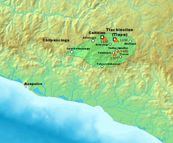
English: A map depicting the aproximate borders of the Kingdom of Tlachinollan in the early 16th century, a Tlapanec kingdom in the territories of modern-day Guerrero, Mexico.
The borders of Tlachinollan are depicted within the green area, and some of the military campaigns launched by the Mexica Empire in the area are depicted as well, along with their dates. Campaigns not shown in the map are: The conquest of Atlitepec (1493) The conquest of Xipetepec (1503-1509) The conquest of Acocozpan (1515) The conquest of Tetenanco (1515) The reconquest of Atlitepec (1515) Source: Vega Sosa, Constanza (1992). "The Annals of the Tlapanecs". Supplement to the Handbook of Middle American Indians 5: 42—48, 51. Austin: University of Texas Press.Español: Un mapa representando las fronteras aproximadas del Reino de Tlachinollan a principios del siglo XVI, un reino tlapaneca en los territorios del actual Guerrero, México.
Las fronteras de Tlachinollan son representadas en el área verde, y algunas de las campañas militares lanzadas por el Imperio mexica en el área son mostradas también, junto a sus fechas. Las campañas no mostradas son: La conquista de Atlitepec (1493) La conquista de Xipetepec (1503-1509) La conquista de Acocozpan (1515) La conquista de Tetenanco (1515) La reconquista de Atlitepec (1515) Fuente: Vega Sosa, Constanza (1992). "The Annals of the Tlapanecs". Supplement to the Handbook of Middle American Indians 5: 42—48, 51. Austin: University of Texas Press. |
| Date | |
| Source | Own work |
| Author | ErickTErick |
Licensing
- You are free:
- to share – to copy, distribute and transmit the work
- to remix – to adapt the work
- Under the following conditions:
- attribution – You must give appropriate credit, provide a link to the license, and indicate if changes were made. You may do so in any reasonable manner, but not in any way that suggests the licensor endorses you or your use.
- share alike – If you remix, transform, or build upon the material, you must distribute your contributions under the same or compatible license as the original.
File history
Click on a date/time to view the file as it appeared at that time.
| Date/Time | Thumbnail | Dimensions | User | Comment | |
|---|---|---|---|---|---|
| current | 11:10, 25 December 2021 | | 726 × 601 (445 KB) | ErickTErick | Small technical error correction |
| 01:26, 17 December 2021 |  | 726 × 601 (445 KB) | ErickTErick | Uploaded own work with UploadWizard |
File usage
Global file usage
The following other wikis use this file:
- Usage on es.wikipedia.org

Recent Comments