How Can We Help?
You are here:
< Back
Size of this preview: 800 × 206 pixels. Other resolutions: 320 × 82 pixels | 640 × 165 pixels | 1,024 × 264 pixels | 3,608 × 929 pixels.
Original file (3,608 × 929 pixels, file size: 979 KB, MIME type: image/jpeg)
Summary
DescriptionSt Louis County MO Government Center rectilinear1.jpg |
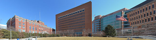
English: St. Louis County, Missouri Government Center. From left to right: St. Louis County Police Headquarters, Lawrence K. Roos County Government Building, Buzz Westfall Justice Center, St. Louis County Courts Building |
Date | |
Source | Own work |
Author | Kbh3rd |
Camera location | 38° 38′ 57.84″ N, 90° 20′ 22.6″ W | View this and other nearby images on: OpenStreetMap | 38.649400; -90.339610 |
---|
This image was created with Hugin.
This photograph was taken with a Nikon D3100
Licensing
I, the copyright holder of this work, hereby publish it under the following license:
This file is licensed under the Creative Commons Attribution 4.0 International license.
- You are free:
- to share – to copy, distribute and transmit the work
- to remix – to adapt the work
- Under the following conditions:
- attribution – You must give appropriate credit, provide a link to the license, and indicate if changes were made. You may do so in any reasonable manner, but not in any way that suggests the licensor endorses you or your use.
Annotations InfoField | This image is annotated: View the annotations at Commons |
131
338
1155
532
3608
929
St. Louis County Police Headquarters
1281
18
884
848
3608
929
Lawrence K. Roos County Government Building
2165
167
762
685
3608
929
Buzz Westfall Justice Center
2909
5
695
762
3608
929
Courts Building
Items portrayed in this file
depicts
creator
some value
Wikimedia username: Kbh3rd
author name string: Kbh3rd
copyright status
copyrighted
copyright license
Creative Commons Attribution 4.0 International
inception
7 March 2015
source of file
original creation by uploader
coordinates of the point of view
38°38'57.84"N, 90°20'22.60"W
File history
Click on a date/time to view the file as it appeared at that time.
Date/Time | Thumbnail | Dimensions | User | Comment | |
---|---|---|---|---|---|
current | 00:55, 8 March 2015 | 3,608 × 929 (979 KB) | Kbh3rd | User created page with UploadWizard |
File usage
The following pages on the English Wikipedia use this file (pages on other projects are not listed):
Metadata
This file contains additional information, probably added from the digital camera or scanner used to create or digitize it.
If the file has been modified from its original state, some details may not fully reflect the modified file.
Latitude | 38° 38′ 18.7″ N |
---|---|
Longitude | 90° 20′ 44.41″ W |
Altitude | 160 meters above sea level |
City shown | Clayton |
Credit/Provider | Wikimedia Commons by Kbh3rd |
Copyright holder | http://en.wikipedia.org/wiki/Kbh3rd |
Image title | St. Louis, MO, County Government Center |
Horizontal resolution | 150 dpi |
Vertical resolution | 150 dpi |
Y and C positioning | Centered |
Reference for direction of image | True direction |
Direction of image | 0 |
Geodetic survey data used | WGS-84 |
GPS tag version | 2.3.0.0 |
Special instructions | Lat 38.638527, Lon -90.34567 - Bearing: 0 - Altitude: 160m |
Sublocation of city shown | St. Louis Co. Gov't Center |
Province or state shown | Missouri |
Country shown | US |
IIM version | 4 |
Categories
-
Annuals36
-
Bulbs, Corms & Tubers41
-
Ferns27
-
Fruits3
-
Garden Plants23
-
Grasses26
-
Herb17
-
Insects1
-
Mammals1
-
Midwest Native Plants0
-
Northeast Native Plants112
-
Perennials123
-
Rose1
-
Shrubs47
-
Trees112
-
Tropical Plants53
-
Upland Birds5
-
Vines18
-
Viola Tricolor1
-
Water Gardening & Plants9
-
Waterfowl0
-
Wetland Birds0
-
Wetland Plants4
-
Wildbirds172
-
Wildflowers1
-
Woodland Plants29
Table of Contents
Recent Comments