How Can We Help?
You are here:
< Back
Size of this preview: 800 × 325 pixels. Other resolutions: 320 × 130 pixels | 640 × 260 pixels | 1,024 × 416 pixels | 1,280 × 521 pixels | 3,671 × 1,493 pixels.
Original file (3,671 × 1,493 pixels, file size: 5.29 MB, MIME type: image/jpeg)
Summary
DescriptionSan Antonio River between Poth and Dewees.jpg |
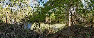
English: San Antonio River crossing under Farm Road 541 between Poth and Dewees, Texas |
Date | Taken on 13 December 2019, 11:49:09 |
Source | Own work |
Author | Dicklyon |
Camera location | 29° 02′ 20.59″ N, 98° 07′ 34.06″ W | View this and other nearby images on: OpenStreetMap | 29.039053; -98.126128 |
---|
Licensing
I, the copyright holder of this work, hereby publish it under the following license:
This file is licensed under the Creative Commons Attribution-Share Alike 4.0 International license.
- You are free:
- to share – to copy, distribute and transmit the work
- to remix – to adapt the work
- Under the following conditions:
- attribution – You must give appropriate credit, provide a link to the license, and indicate if changes were made. You may do so in any reasonable manner, but not in any way that suggests the licensor endorses you or your use.
- share alike – If you remix, transform, or build upon the material, you must distribute your contributions under the same or compatible license as the original.
Items portrayed in this file
depicts
creator
some value
Wikimedia username: Dicklyon
author name string: Dicklyon
copyright status
copyrighted
copyright license
Creative Commons Attribution-ShareAlike 4.0 International
inception
13 December 2019
captured with
Pixel 3
coordinates of the point of view
29°2'20.591"N, 98°7'34.061"W
source of file
original creation by uploader
media type
image/jpeg
File history
Click on a date/time to view the file as it appeared at that time.
Date/Time | Thumbnail | Dimensions | User | Comment | |
---|---|---|---|---|---|
current | 00:10, 16 December 2019 | 3,671 × 1,493 (5.29 MB) | Dicklyon | User created page with UploadWizard |
File usage
The following pages on the English Wikipedia use this file (pages on other projects are not listed):
Metadata
This file contains additional information, probably added from the digital camera or scanner used to create or digitize it.
If the file has been modified from its original state, some details may not fully reflect the modified file.
Camera manufacturer | |
---|---|
Camera model | Pixel 3 |
Date and time of data generation | 11:49, 13 December 2019 |
Latitude | 29° 2′ 20.59″ N |
Longitude | 98° 7′ 34.06″ W |
Altitude | 73.48 meters above sea level |
Width | 3,996 px |
Height | 1,653 px |
Orientation | Normal |
Software used | Picasa |
File change date and time | 11:49, 13 December 2019 |
Subsampling ratio of Y to C |
|
Exif version | 2.2 |
Date and time of digitizing | 11:49, 13 December 2019 |
Light source | Unknown |
DateTime subseconds | 391 |
DateTimeOriginal subseconds | 391 |
DateTimeDigitized subseconds | 391 |
Color space | sRGB |
Unique image ID | c3260cb141b49c680000000000000000 |
GPS time (atomic clock) | 17:46 |
GPS date | 13 December 2019 |
GPS tag version | 2.2.0.0 |
Categories
-
Annuals36
-
Bulbs, Corms & Tubers41
-
Ferns27
-
Fruits3
-
Garden Plants23
-
Grasses26
-
Herb17
-
Insects1
-
Mammals1
-
Midwest Native Plants0
-
Northeast Native Plants112
-
Perennials123
-
Rose1
-
Shrubs47
-
Trees112
-
Tropical Plants53
-
Upland Birds5
-
Vines18
-
Viola Tricolor1
-
Water Gardening & Plants9
-
Waterfowl0
-
Wetland Birds0
-
Wetland Plants4
-
Wildbirds172
-
Wildflowers1
-
Woodland Plants29
Table of Contents
Recent Comments