
How Can We Help?
No higher resolution available.
Old_Gaol,_Cupar_-_geograph.org.uk_-_199579.jpg (640 × 364 pixels, file size: 53 KB, MIME type: image/jpeg)
Summary
| Description |
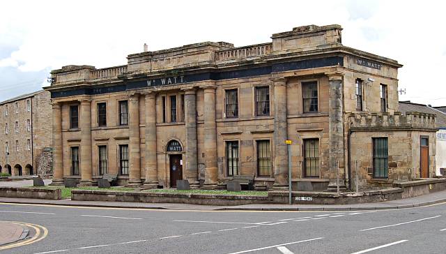
English: Old Gaol, Cupar. Built in 1813/14 and in use as the town jail until a new jail, see98130 was opened in 1844. It was then used up until 1895 by the local militia when it was sold to local seed merchant William Watt. It was used by them right up until 1988. |
| Date | |
| Source | From geograph.org.uk |
| Author | Jim Bain |
| Attribution (required by the license) | Jim Bain / Old Gaol, Cupar / |
| Camera location | | View this and other nearby images on: OpenStreetMap |
|---|
| Object location | | View this and other nearby images on: OpenStreetMap |
|---|
Licensing

|
This image was taken from the Geograph project collection. See this photograph's page on the Geograph website for the photographer's contact details. The copyright on this image is owned by Jim Bain and is licensed for reuse under the Creative Commons Attribution-ShareAlike 2.0 license.
|
This file is licensed under the Creative Commons Attribution-Share Alike 2.0 Generic license.
Attribution: Jim Bain
- You are free:
- to share – to copy, distribute and transmit the work
- to remix – to adapt the work
- Under the following conditions:
- attribution – You must give appropriate credit, provide a link to the license, and indicate if changes were made. You may do so in any reasonable manner, but not in any way that suggests the licensor endorses you or your use.
- share alike – If you remix, transform, or build upon the material, you must distribute your contributions under the same or compatible license as the original.
File history
Click on a date/time to view the file as it appeared at that time.
| Date/Time | Thumbnail | Dimensions | User | Comment | |
|---|---|---|---|---|---|
| current | 17:48, 31 January 2010 | | 640 × 364 (53 KB) | GeographBot | == {{int:filedesc}} == {{Information |description={{en|1=Old Gaol, Cupar. Built in 1813/14 and in use as the town jail until a new jail, see98130 was opened in 1844. It was then used up until 1895 by the local militia when it was sold to local seed me |
File usage
The following pages on the English Wikipedia use this file (pages on other projects are not listed):

_heading:67.00&language=en)
_heading:67.00&language=en)
Recent Comments