
How Can We Help?
Size of this preview: 800 × 533 pixels. Other resolutions: 320 × 213 pixels | 640 × 427 pixels | 1,024 × 683 pixels | 1,280 × 853 pixels | 2,560 × 1,707 pixels | 5,568 × 3,712 pixels.
Original file (5,568 × 3,712 pixels, file size: 18.4 MB, MIME type: image/jpeg)
Summary
| Description |
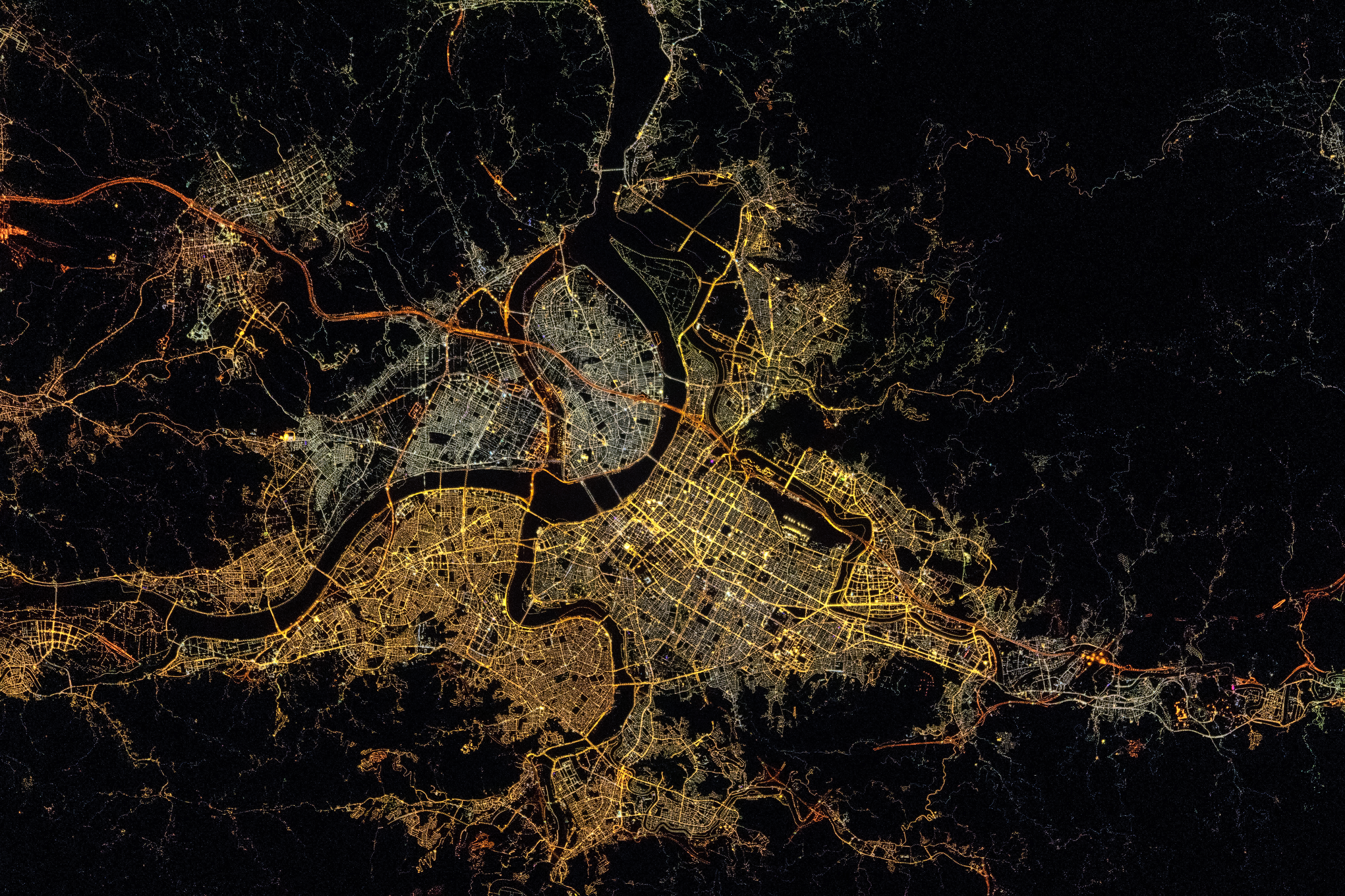
English: A very distinctive city at night with its winding rivers: Taipei!
Français : Au nord de Taïwan, Taipei saute aux yeux avec ses cours d’eau sinueux.
中文(臺灣):在國際太空站上執行遠征65(Expedition 65)任務的太空人佩斯凱(Thomas Pesquet)於臺灣時間2021年7月26日深夜拍攝的大臺北地區,可見燈光形塑出淡水河水系的輪廓。 |
| Date | |
| Source |
Frame 206242 from ISS Expedition 65 Crew Earth Observations Post by Thomas Pesquet on Instagram |
| Author |
Original frame: Thomas Pesquet/The Earth Science and Remote Sensing Unit, NASA Johnson Space Center Stabilization correction by Tiouraren (Y.-C. Tsai) |
| Camera location | | View this and other nearby images on: OpenStreetMap |
|---|
This image or video was catalogued by Johnson Space Center of the United States National Aeronautics and Space Administration (NASA) under Photo ID: ISS065-E-206242. This tag does not indicate the copyright status of the attached work. A normal copyright tag is still required. See Commons:Licensing. Other languages:
|
Licensing
| This file is in the public domain in the United States because it was solely created by NASA. NASA copyright policy states that "NASA material is not protected by copyright unless noted". (See Template:PD-USGov, NASA copyright policy page or JPL Image Use Policy.) | ||
 |
Warnings:
|
File history
Click on a date/time to view the file as it appeared at that time.
| Date/Time | Thumbnail | Dimensions | User | Comment | |
|---|---|---|---|---|---|
| current | 05:32, 6 January 2023 | | 5,568 × 3,712 (18.4 MB) | Tiouraren | Stabilization |
| 05:23, 5 July 2022 |  | 5,568 × 3,712 (4.76 MB) | AskeBot |
File usage
The following pages on the English Wikipedia use this file (pages on other projects are not listed):
Global file usage
The following other wikis use this file:
- Usage on zh.wikipedia.org

Recent Comments