How Can We Help?
You are here:
< Back
Size of this preview: 374 × 599 pixels. Other resolutions: 150 × 240 pixels | 299 × 480 pixels | 479 × 768 pixels | 639 × 1,024 pixels | 1,355 × 2,171 pixels.
Original file (1,355 × 2,171 pixels, file size: 772 KB, MIME type: image/jpeg)
Summary
DescriptionI-110 at I-105 aerial.jpg |
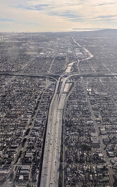
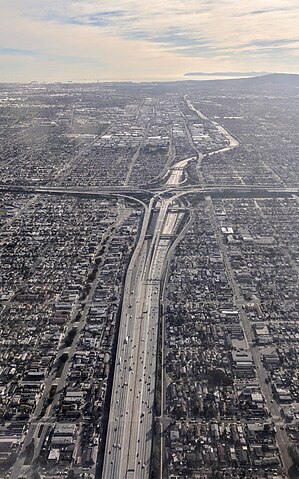
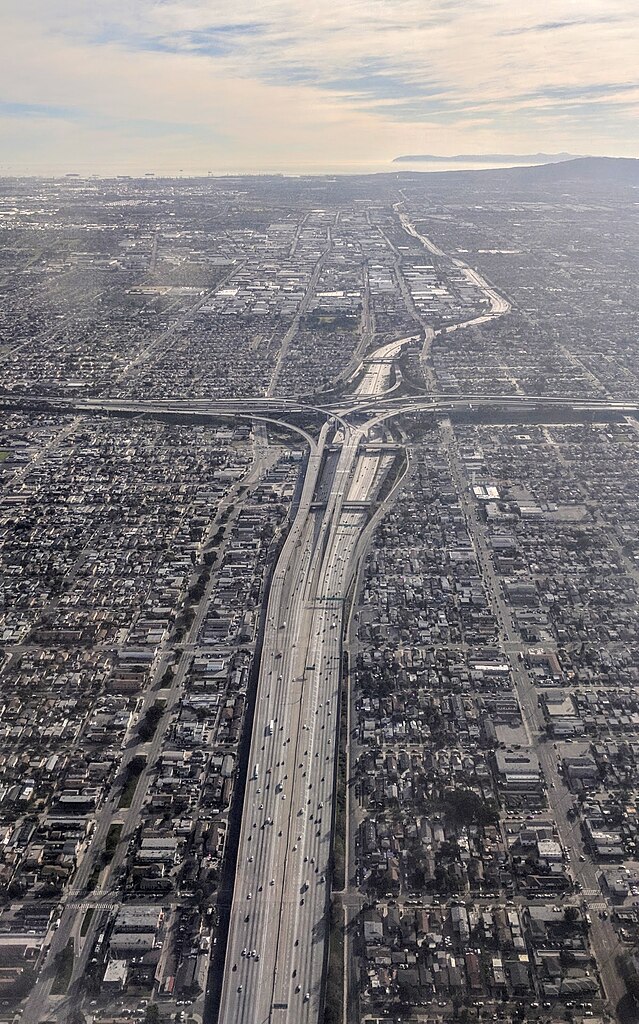
English: Aerial view from the north of the Harbor Freeway, Interstate 110, and its interchange with the Century Freeway, Interstate 105, on approach to Los Angeles International Airport. The Palos Verdes Peninsula and Santa Catalina Island are visible in the distance. |
Date | |
Source | Own work |
Author | Dicklyon |
Camera location | 33° 57′ 00.34″ N, 118° 15′ 08.45″ W | View this and other nearby images on: OpenStreetMap | 33.950094; -118.252347 |
---|
Licensing
I, the copyright holder of this work, hereby publish it under the following license:
This file is licensed under the Creative Commons Attribution-Share Alike 4.0 International license.
- You are free:
- to share – to copy, distribute and transmit the work
- to remix – to adapt the work
- Under the following conditions:
- attribution – You must give appropriate credit, provide a link to the license, and indicate if changes were made. You may do so in any reasonable manner, but not in any way that suggests the licensor endorses you or your use.
- share alike – If you remix, transform, or build upon the material, you must distribute your contributions under the same or compatible license as the original.
Items portrayed in this file
depicts
creator
some value
Wikimedia username: Dicklyon
author name string: Dicklyon
copyright status
copyrighted
copyright license
Creative Commons Attribution-ShareAlike 4.0 International
coordinates of the point of view
33°57'0.338"N, 118°15'8.449"W
source of file
original creation by uploader
inception
8 January 2019
File history
Click on a date/time to view the file as it appeared at that time.
Date/Time | Thumbnail | Dimensions | User | Comment | |
---|---|---|---|---|---|
current | 05:33, 9 January 2019 | 1,355 × 2,171 (772 KB) | Dicklyon | User created page with UploadWizard |
File usage
The following pages on the English Wikipedia use this file (pages on other projects are not listed):
Global file usage
The following other wikis use this file:
- Usage on pt.wikipedia.org
- Usage on www.wikidata.org
Metadata
This file contains additional information, probably added from the digital camera or scanner used to create or digitize it.
If the file has been modified from its original state, some details may not fully reflect the modified file.
Camera manufacturer | |
---|---|
Camera model | Pixel |
Exposure time | 51/125,000 sec (0.000408) |
F-number | f/2 |
ISO speed rating | 51 |
Date and time of data generation | 15:27, 8 January 2019 |
Lens focal length | 4.67 mm |
Latitude | 33° 57′ 0.34″ N |
Longitude | 118° 15′ 8.45″ W |
Altitude | 978 meters above sea level |
Width | 1,512 px |
Height | 2,688 px |
Orientation | Normal |
Horizontal resolution | 72 dpi |
Vertical resolution | 72 dpi |
Software used | HDR+ 1.0.225828303z |
File change date and time | 15:27, 8 January 2019 |
Y and C positioning | Centered |
Exposure Program | Normal program |
Exif version | 2.2 |
Date and time of digitizing | 15:27, 8 January 2019 |
Meaning of each component |
|
Shutter speed | 11.26 |
APEX aperture | 2 |
APEX brightness | 9.23 |
Exposure bias | 0 |
Maximum land aperture | 2 APEX (f/2) |
Subject distance | 2.656 meters |
Metering mode | Center weighted average |
Flash | Flash did not fire, auto mode |
DateTime subseconds | 321353 |
DateTimeOriginal subseconds | 321353 |
DateTimeDigitized subseconds | 321353 |
Supported Flashpix version | 1 |
Color space | sRGB |
Sensing method | One-chip color area sensor |
Scene type | A directly photographed image |
Custom image processing | Custom process |
Exposure mode | Auto exposure |
White balance | Auto white balance |
Digital zoom ratio | 0 |
Focal length in 35 mm film | 26 mm |
Scene capture type | Standard |
Contrast | Normal |
Saturation | Normal |
Sharpness | Normal |
Subject distance range | Close view |
Unique image ID | 0bfae61f436df4550000000000000000 |
GPS time (atomic clock) | 22:27 |
Measurement precision | Poor (52) |
GPS date | 8 January 2019 |
GPS tag version | 0.0.2.2 |
Categories
-
Annuals36
-
Bulbs, Corms & Tubers41
-
Ferns27
-
Fruits3
-
Garden Plants23
-
Grasses26
-
Herb17
-
Insects1
-
Mammals1
-
Midwest Native Plants0
-
Northeast Native Plants112
-
Perennials123
-
Rose1
-
Shrubs47
-
Trees112
-
Tropical Plants53
-
Upland Birds5
-
Vines18
-
Viola Tricolor1
-
Water Gardening & Plants9
-
Waterfowl0
-
Wetland Birds0
-
Wetland Plants4
-
Wildbirds172
-
Wildflowers1
-
Woodland Plants29
Table of Contents
Recent Comments