
How Can We Help?
Size of this preview: 552 × 600 pixels. Other resolutions: 221 × 240 pixels | 442 × 480 pixels | 760 × 826 pixels.
Original file (760 × 826 pixels, file size: 122 KB, MIME type: image/png)
Summary
| Description |
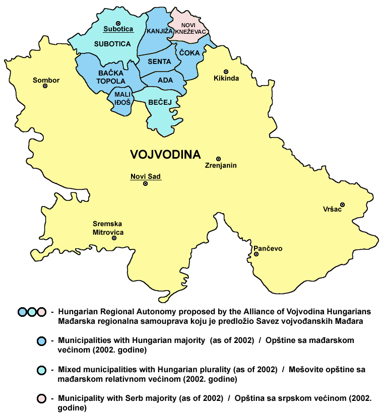
English: Map of the proposed Hungarian Regional Autonomy in northern Vojvodina (proposal of the Alliance of Vojvodina Hungarians political party).
Српски / srpski: Мапа предложене Мађарске регионалне самоуправе на северу Војводине (предлог политичке партије Савез војвођанских Мађара). |
| Date | 10 February 2009 (original upload date) |
| Source | No machine-readable source provided. Own work assumed (based on copyright claims). |
| Author | No machine-readable author provided. PANONIAN assumed (based on copyright claims). |
References
Created according to these sources:
- 1. Info about borders of the proposed Hungarian Regional Autonomy was found here:
- The Alliance of Vojvodina Hungarians web site - [1][dead link] (Dokument o autonomiji - Mađarska regionalna samouprava)
- [2] (Uloga mađarske zajednice u Srbiji, Helsinški odbor za ljudska prava u Srbiji, Beograd, 2009, page 20)
- [3] (Prevladavanje prošlosti i potencijal za nadvladavanje inter-etničkih sukoba u Vojvodini, Centar za razvoj civilnog društva, 2002, page 78)
- [4] (Vojvodina expects imminent endorsement of its new Statute of Autonomy, www.nationalia.info, 18/12/2008)
- [5] (Istraživanje novosadske Agencije Skan pokazalo - Vojvođani hoće veću autonomiju, Glas javnosti, 07. Mart 2001.)
- 2. Info about ethnic composition of municipalities: Popis stanovništva, domaćinstava i stanova u 2002, Stanovništvo, knjiga 1, Nacionalna ili etnička pripadnost - podaci po naseljima, Republika Srbija - Republički zavod za statistiku, Beograd, februar 2003.
- 3. Provincial and municipal borders and locations of sizable cities: Slobodan Radovanović, Geografski atlas, Magic Map, Smederevska Palanka, 2001.
Source and licence
self made map by user:PANONIAN
Licensing
| I, the copyright holder of this work, release this work into the public domain. This applies worldwide. In some countries this may not be legally possible; if so: I grant anyone the right to use this work for any purpose, without any conditions, unless such conditions are required by law. |
File history
Click on a date/time to view the file as it appeared at that time.
| Date/Time | Thumbnail | Dimensions | User | Comment | |
|---|---|---|---|---|---|
| current | 19:30, 25 October 2011 | | 760 × 826 (122 KB) | PANONIAN | improved version |
| 13:50, 19 July 2009 |  | 957 × 638 (44 KB) | PANONIAN | ||
| 00:03, 10 February 2009 |  | 972 × 579 (22 KB) | PANONIAN | map of the proposed Hungarian regional autonomy in Vojvodina (self made) {{PD-self}} Category:Maps of the politics of Vojvodina |
File usage
The following pages on the English Wikipedia use this file (pages on other projects are not listed):
Global file usage
The following other wikis use this file:
- Usage on be-tarask.wikipedia.org
- Usage on br.wikipedia.org
- Usage on fr.wikipedia.org
- Usage on hr.wikipedia.org
- Usage on hu.wikipedia.org
- Usage on it.wikipedia.org
- Usage on ro.wikipedia.org
- Usage on ru.wikipedia.org
- Usage on sh.wikipedia.org
- Usage on sr.wikipedia.org
- Usage on tr.wikipedia.org
- Usage on uk.wikipedia.org

Recent Comments