
How Can We Help?

Size of this preview: 800 × 251 pixels. Other resolutions: 320 × 100 pixels | 640 × 201 pixels | 1,024 × 321 pixels | 1,280 × 401 pixels | 2,560 × 802 pixels | 7,986 × 2,502 pixels.
Original file (7,986 × 2,502 pixels, file size: 15 MB, MIME type: image/jpeg)
Summary
| Description |
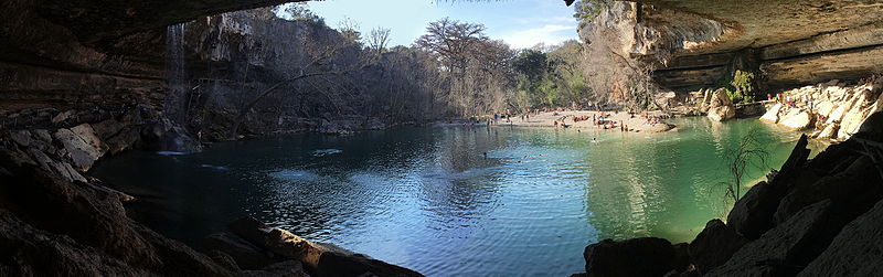
English: Hamilton Pool Preserve in Travis County, Texas |
| Date | |
| Source | Own work |
| Author | Fredlyfish4 |
| Camera location | | View this and other nearby images on: OpenStreetMap |
|---|
Licensing
I, the copyright holder of this work, hereby publish it under the following license:
This file is licensed under the Creative Commons Attribution-Share Alike 4.0 International license.
- You are free:
- to share – to copy, distribute and transmit the work
- to remix – to adapt the work
- Under the following conditions:
- attribution – You must give appropriate credit, provide a link to the license, and indicate if changes were made. You may do so in any reasonable manner, but not in any way that suggests the licensor endorses you or your use.
- share alike – If you remix, transform, or build upon the material, you must distribute your contributions under the same or compatible license as the original.
| File created by Fredlyfish4 | |
| Permission is granted for use under CC BY-SA 4.0 (or a similar license) for this file created by the author.
Please let the author know if you use this work outside of Wikimedia projects by sending an email to
|
File history
Click on a date/time to view the file as it appeared at that time.
| Date/Time | Thumbnail | Dimensions | User | Comment | |
|---|---|---|---|---|---|
| current | 18:16, 10 March 2016 | 7,986 × 2,502 (15 MB) | Fredlyfish4 | User created page with UploadWizard |
File usage
The following pages on the English Wikipedia use this file (pages on other projects are not listed):

Recent Comments