
How Can We Help?

Size of this preview: 800 × 600 pixels. Other resolutions: 320 × 240 pixels | 640 × 480 pixels | 1,024 × 768 pixels | 1,280 × 960 pixels | 2,560 × 1,920 pixels | 2,848 × 2,136 pixels.
Original file (2,848 × 2,136 pixels, file size: 2.92 MB, MIME type: image/jpeg)
Summary
| Description |
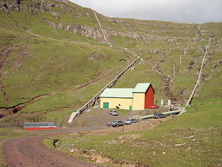
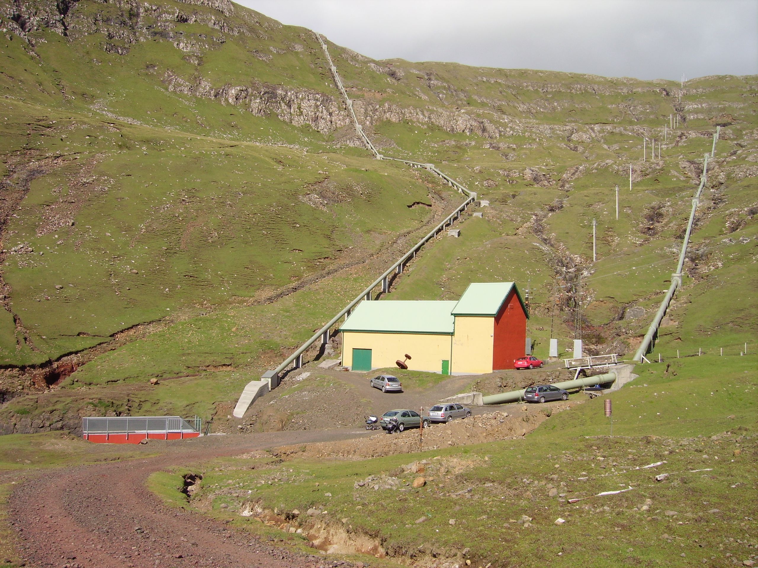
English: The hydro-electric powerplant in Botni was built in 1920-21, ready to use in 1921. The people in Vágur celebrated the opening of this first electric power plant in the Faroes on 18 July 1921. The mayor, Petur Dahl, also known as Petur á Gørðunum, arranged a party in the public school, where he switched on the lights for the first time. The hydro-electric powerplant in Botni is still in use, but in 1982 an additional powerplant was built on Oyrarnar in Vágur, next to the sea on the southern side of the fjord. These two powerplants provide electricity to the island Suðuroy, which is not connected to the main area due to large distance. When they have a black-out in the main area of the Faroes, Suðuroy still has power and vice-versa. In 1963 Elfelagið Suðuroy joined SEV, which is for the whole country (Faroe Islands). Føroyskt: Vatnorkuverkið í Botni (elektrisitetsverkið í Botni), Botnur í Vági, var bygt í 1921 og var tað fyrsta av sínum slag í Føroyum. Tað er enn í nýtslu og veit streym til borgarar og virki í Suðuroynni, saman við elverkinum á Oyrunum í Vági og elverkinum í Trongisvági. Vatnorkuverkið í Botni er tað einasta vatnorkuverkið í Suðuroynni. Onnur vatnorkuverk eru: Heygaverkið, Fossáverkið, Mýruverkiðm Eiðisverkið og Strond. Tað var Vágs kommuna ið bygdi verkið. Borgarstjóri tá var Petur Dahl, eisini kendur sum Petur á Gørðunum. |
| Date | |
| Source | Own work |
| Author | EileenSanda |
| Camera location | | View this and other nearby images on: OpenStreetMap |
|---|
| Object location | | View this and other nearby images on: OpenStreetMap |
|---|
Licensing
I, the copyright holder of this work, hereby publish it under the following license:
This file is licensed under the Creative Commons Attribution-Share Alike 3.0 Unported license.
- You are free:
- to share – to copy, distribute and transmit the work
- to remix – to adapt the work
- Under the following conditions:
- attribution – You must give appropriate credit, provide a link to the license, and indicate if changes were made. You may do so in any reasonable manner, but not in any way that suggests the licensor endorses you or your use.
- share alike – If you remix, transform, or build upon the material, you must distribute your contributions under the same or compatible license as the original.
File history
Click on a date/time to view the file as it appeared at that time.
| Date/Time | Thumbnail | Dimensions | User | Comment | |
|---|---|---|---|---|---|
| current | 12:29, 4 December 2012 | | 2,848 × 2,136 (2.92 MB) | EileenSanda | User created page with UploadWizard |
File usage
The following pages on the English Wikipedia use this file (pages on other projects are not listed):
Global file usage
The following other wikis use this file:
- Usage on da.wikipedia.org
- Usage on es.wikipedia.org
- Usage on et.wikipedia.org
- Usage on fo.wikipedia.org
- Usage on no.wikipedia.org
- Usage on ru.wikipedia.org
- Usage on sv.wikipedia.org
- Usage on www.wikidata.org
- Usage on zh.wikipedia.org

Recent Comments