
How Can We Help?

Size of this preview: 800 × 583 pixels. Other resolutions: 320 × 233 pixels | 640 × 467 pixels | 985 × 718 pixels.
Original file (985 × 718 pixels, file size: 193 KB, MIME type: image/jpeg)
Summary
| Description |
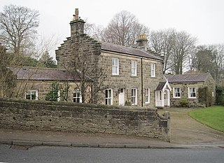
English: Dacre railway station site, Yorkshire Opened in 1862 by the North Eastern Railway on its line from Harrogate to Pateley Bridge, this station closed to passengers in 1950. Forecourt. |
| Date | |
| Source | From geograph.org.uk |
| Author | Nigel Thompson |
| Permission (Reusing this file) |
Creative Commons Attribution Share-alike license 2.0 |
| Attribution (required by the license) | Nigel Thompson / Dacre railway station site, Yorkshire / |
| Camera location | | View this and other nearby images on: OpenStreetMap |
|---|
| Object location | | View this and other nearby images on: OpenStreetMap |
|---|
Licensing

|
This image was taken from the Geograph project collection. See this photograph's page on the Geograph website for the photographer's contact details. The copyright on this image is owned by Nigel Thompson and is licensed for reuse under the Creative Commons Attribution-ShareAlike 2.0 license.
|
This file is licensed under the Creative Commons Attribution-Share Alike 2.0 Generic license.
Attribution: Nigel Thompson
- You are free:
- to share – to copy, distribute and transmit the work
- to remix – to adapt the work
- Under the following conditions:
- attribution – You must give appropriate credit, provide a link to the license, and indicate if changes were made. You may do so in any reasonable manner, but not in any way that suggests the licensor endorses you or your use.
- share alike – If you remix, transform, or build upon the material, you must distribute your contributions under the same or compatible license as the original.
File history
Click on a date/time to view the file as it appeared at that time.
| Date/Time | Thumbnail | Dimensions | User | Comment | |
|---|---|---|---|---|---|
| current | 07:17, 28 May 2018 | | 985 × 718 (193 KB) | Finavon | rotated |
| 05:36, 28 May 2018 |  | 1,024 × 768 (203 KB) | Schlosser67 | Transferred from geograph.co.uk using [https://tools.wmflabs.org/geograph2commons/ geograph2commons] |
File usage
The following pages on the English Wikipedia use this file (pages on other projects are not listed):
Global file usage
The following other wikis use this file:
- Usage on www.wikidata.org

.jpg¶ms=054.052329_N_-001.701351_E_globe:Earth_type:camera_region:GB_source:geograph-osgb36(SE19656186)_heading:270.00&language=en)
.jpg¶ms=054.052330_N_-001.702110_E_globe:Earth_class:object_type:object_source:geograph-osgb36(SE19606186)_heading:270.00&language=en)
Recent Comments