How Can We Help?
You are here:
< Back
Size of this preview: 729 × 600 pixels. Other resolutions: 292 × 240 pixels | 584 × 480 pixels | 934 × 768 pixels | 1,245 × 1,024 pixels | 1,357 × 1,116 pixels.
Original file (1,357 × 1,116 pixels, file size: 1.1 MB, MIME type: image/jpeg)
Summary
DescriptionCupnoodles Museum Yokohama 2017.jpg |
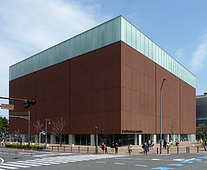
Deutsch: Außenansicht CUPNOODLES MUSEUM (Momofuku Ando Instant Ramen Museum) in Yokohama, 2017
English: CUPNOODLES MUSEUM (Momofuku Ando Instant Ramen Museum) in Yokohama, 2017, front view |
Date | |
Source | picture taken by Natalie Lauer April 2017 |
Author | Natalie Lauer |
Camera location | 35° 27′ 20.12″ N, 139° 38′ 17.02″ E | View this and other nearby images on: OpenStreetMap | 35.455589; 139.638061 |
---|
Licensing
This file is licensed under the Creative Commons Attribution-Share Alike 4.0 International license.
- You are free:
- to share – to copy, distribute and transmit the work
- to remix – to adapt the work
- Under the following conditions:
- attribution – You must give appropriate credit, provide a link to the license, and indicate if changes were made. You may do so in any reasonable manner, but not in any way that suggests the licensor endorses you or your use.
- share alike – If you remix, transform, or build upon the material, you must distribute your contributions under the same or compatible license as the original.
Items portrayed in this file
depicts
CupNoodles Museum Yokohama
copyright status
copyrighted
copyright license
Creative Commons Attribution-ShareAlike 4.0 International
inception
15 April 2017
coordinates of the point of view
35°27'20.120"N, 139°38'17.020"E
captured with
Panasonic Lumix DMC-TZ10
exposure time
0.0025 second
f-number
5
focal length
4.4 millimetre
ISO speed
80
media type
image/jpeg
instance of
photograph
checksum
448ef35d98a6ba09efa872fc3d2db841e8bbe163
determination method: SHA-1
data size
1,152,563 byte
height
1,116 pixel
width
1,357 pixel
File history
Click on a date/time to view the file as it appeared at that time.
Date/Time | Thumbnail | Dimensions | User | Comment | |
---|---|---|---|---|---|
current | 13:06, 23 September 2022 | 1,357 × 1,116 (1.1 MB) | Nightflyer | bearbeitet | |
18:57, 28 April 2017 | 1,529 × 1,156 (1.15 MB) | Ejw0851 | User created page with UploadWizard |
File usage
The following pages on the English Wikipedia use this file (pages on other projects are not listed):
Global file usage
The following other wikis use this file:
Metadata
This file contains additional information, probably added from the digital camera or scanner used to create or digitize it.
If the file has been modified from its original state, some details may not fully reflect the modified file.
Camera manufacturer | Panasonic |
---|---|
Camera model | DMC-TZ10 |
Exposure time | 1/400 sec (0.0025) |
F-number | f/5 |
ISO speed rating | 80 |
Date and time of data generation | 13:09, 15 April 2017 |
Lens focal length | 4.4 mm |
Latitude | 35° 27′ 20.12″ N |
Longitude | 139° 38′ 17.02″ E |
Orientation | Normal |
Horizontal resolution | 300 dpi |
Vertical resolution | 300 dpi |
Software used | Adobe Photoshop CS2 Macintosh |
File change date and time | 20:48, 28 April 2017 |
Y and C positioning | Co-sited |
Exposure Program | Landscape mode (for landscape photos with the background in focus) |
Exif version | 2.21 |
Date and time of digitizing | 13:09, 15 April 2017 |
Meaning of each component |
|
Image compression mode | 4 |
Exposure bias | 0 |
Maximum land aperture | 3.44 APEX (f/3.29) |
Metering mode | Pattern |
Light source | Unknown |
Flash | Flash did not fire, compulsory flash suppression |
Supported Flashpix version | 1 |
Color space | sRGB |
Sensing method | One-chip color area sensor |
File source | Digital still camera |
Scene type | A directly photographed image |
Custom image processing | Normal process |
Exposure mode | Auto exposure |
White balance | Auto white balance |
Focal length in 35 mm film | 27 mm |
Scene capture type | Standard |
Scene control | None |
Contrast | Normal |
Saturation | Normal |
Sharpness | Normal |
GPS time (atomic clock) | 04:08 |
Satellites used for measurement | 4 |
Receiver status | Measurement in progress |
Measurement mode | 2-dimensional measurement |
Measurement precision | Poor (4.4) |
Geodetic survey data used | WGS-84 |
GPS date | 15 April 2017 |
GPS tag version | 0.0.2.2 |
Supported Flashpix version | 1 |
Image width | 1,529 px |
Image height | 1,156 px |
Date metadata was last modified | 22:48, 28 April 2017 |
Categories
-
Annuals36
-
Bulbs, Corms & Tubers41
-
Ferns27
-
Fruits3
-
Garden Plants23
-
Grasses26
-
Herb17
-
Insects1
-
Mammals1
-
Midwest Native Plants0
-
Northeast Native Plants112
-
Perennials123
-
Rose1
-
Shrubs47
-
Trees112
-
Tropical Plants53
-
Upland Birds5
-
Vines18
-
Viola Tricolor1
-
Water Gardening & Plants9
-
Waterfowl0
-
Wetland Birds0
-
Wetland Plants4
-
Wildbirds172
-
Wildflowers1
-
Woodland Plants29
Table of Contents
Recent Comments