
How Can We Help?
No higher resolution available.
CrossHarborRailFacilityMap.png (415 × 349 pixels, file size: 15 KB, MIME type: image/png)
Summary
| Description |
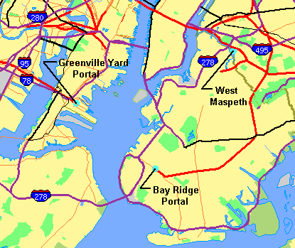
Map showing New York Harbor with adjacent parts of New York and New Jersey obtained from U.S. Census Bureau, with facilities of proposed Cross-Harbor Rail Tunnel shown on map by Cross Harbor Freight Movement Project superimposed and legends added by hand. |
|---|---|
| Source |
Mainly work of a U.S. government agency. The base map is from the US Census TIGER map browser, and is public domain. |
| Date | |
| Author | |
| Permission (Reusing this file) |
See below.
|
Licensing
File history
Click on a date/time to view the file as it appeared at that time.
| Date/Time | Thumbnail | Dimensions | User | Comment | |
|---|---|---|---|---|---|
| current | 18:27, 21 May 2006 | | 415 × 349 (15 KB) | Craig Bolon (talk | contribs) | Map showing New York Harbor with adjacent parts of New York and New Jersey obtained from U.S. Census Bureau, with facilities of proposed Cross-Harbor Rail Tunnel shown on map by Cross Harbor Freight Movement Project superimposed and legends added by hand. |
| 16:31, 21 May 2006 |  | 415 × 349 (15 KB) | Craig Bolon (talk | contribs) | Map showing New York Harbor with adjacent parts of New York and New Jersey obtained from U.S. Census Bureau, with facilities of proposed Cross-Harbor Rail Tunnel shown on map by Cross Harbor Freight Movement Project superimposed and legends added by hand. |
You cannot overwrite this file.
File usage
The following pages on the English Wikipedia use this file (pages on other projects are not listed):

Recent Comments