
How Can We Help?

Size of this preview: 800 × 483 pixels. Other resolutions: 320 × 193 pixels | 640 × 386 pixels | 1,024 × 618 pixels | 1,280 × 773 pixels | 2,302 × 1,390 pixels.
Original file (2,302 × 1,390 pixels, file size: 1.61 MB, MIME type: image/jpeg)
Summary
| Description |
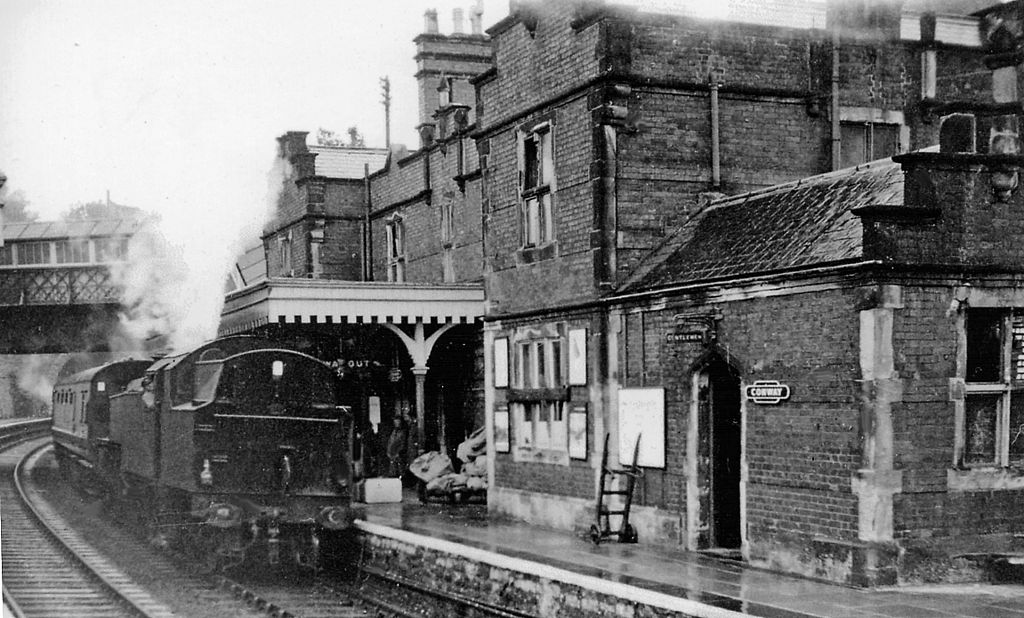
English: Conway Station, with Up train. View westward, towards Bangor and Holyhead: ex-LNW Chester - Holyhead main line. The station was closed 14/2/66, but reopened 27/6/87 as 'Conwy'. The 'Snowdonian' tourist train, which ran in the summer season from Llanberis (otherwise closed to passengers) – Bangor – Rhyl and back, is headed by bunker-first Stanier 4MT 2-6-4T No. 42487. Conwy Castle is immediately up to the right. |
| Date | |
| Source | From geograph.org.uk |
| Author | Ben Brooksbank |
| Permission (Reusing this file) |
Creative Commons Attribution Share-alike license 2.0 |
| Attribution (required by the license) | Ben Brooksbank / Conway Station, with Up train / |
| Camera location | | View this and other nearby images on: OpenStreetMap |
|---|
Licensing

|
This image was taken from the Geograph project collection. See this photograph's page on the Geograph website for the photographer's contact details. The copyright on this image is owned by Ben Brooksbank and is licensed for reuse under the Creative Commons Attribution-ShareAlike 2.0 license.
|
This file is licensed under the Creative Commons Attribution-Share Alike 2.0 Generic license.
Attribution: Ben Brooksbank
- You are free:
- to share – to copy, distribute and transmit the work
- to remix – to adapt the work
- Under the following conditions:
- attribution – You must give appropriate credit, provide a link to the license, and indicate if changes were made. You may do so in any reasonable manner, but not in any way that suggests the licensor endorses you or your use.
- share alike – If you remix, transform, or build upon the material, you must distribute your contributions under the same or compatible license as the original.
File history
Click on a date/time to view the file as it appeared at that time.
| Date/Time | Thumbnail | Dimensions | User | Comment | |
|---|---|---|---|---|---|
| current | 18:27, 13 June 2012 | | 2,302 × 1,390 (1.61 MB) | Chevin | == {{int:filedesc}} == {{Information |Description={{en|1='''Conway Station, with Up train.'''<br/> View westward, towards Bangor and Holyhead: ex-LNW Chester - Holyhead main line. The station was closed 14/2/66, but reopened 27/6/87 as 'Conwy'. The 'Sn... |
File usage
The following pages on the English Wikipedia use this file (pages on other projects are not listed):

Recent Comments