
How Can We Help?
Size of this preview: 501 × 599 pixels. Other resolutions: 201 × 240 pixels | 401 × 480 pixels.
Original file (800 × 957 pixels, file size: 417 KB, MIME type: image/jpeg)
Summary
| Description |
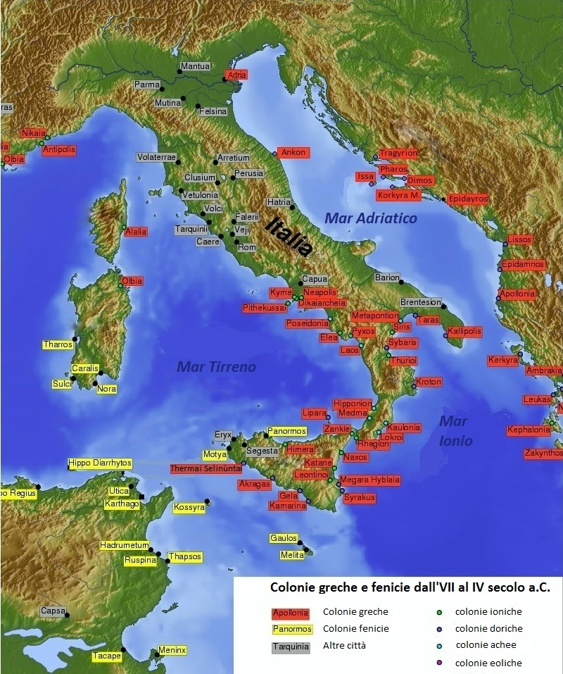
Italiano: Carta geografica storica con la localizzazione delle colonie greche e fenicie in Italia e nelle regioni circostanti, dall'VIII al IV secolo a.C. |
| Date | |
| Source | Rielaborazione di una carta già presente in Commons |
| Author | sono io l'autore |
| Permission (Reusing this file) |
libera |

|
This historical map image could be re-created using vector graphics as an SVG file. This has several advantages; see Commons:Media for cleanup for more information. If an SVG form of this image is available, please upload it and afterwards replace this template with
{{vector version available|new image name}}.
It is recommended to name the SVG file “Colonie greche e fenicie in Italia.svg”—then the template Vector version available (or Vva) does not need the new image name parameter. |
Licensing
Gep at Italian Wikipedia, the copyright holder of this work, hereby publishes it under the following licenses:

|
Permission is granted to copy, distribute and/or modify this document under the terms of the GNU Free Documentation License, Version 1.2 or any later version published by the Free Software Foundation; with no Invariant Sections, no Front-Cover Texts, and no Back-Cover Texts. A copy of the license is included in the section entitled GNU Free Documentation License. |
This file is licensed under the Creative Commons Attribution-Share Alike 3.0 Unported, 2.5 Generic, 2.0 Generic and 1.0 Generic license.
Attribution: Gep at Italian Wikipedia
- You are free:
- to share – to copy, distribute and transmit the work
- to remix – to adapt the work
- Under the following conditions:
- attribution – You must give appropriate credit, provide a link to the license, and indicate if changes were made. You may do so in any reasonable manner, but not in any way that suggests the licensor endorses you or your use.
- share alike – If you remix, transform, or build upon the material, you must distribute your contributions under the same or compatible license as the original.
You may select the license of your choice.
Original upload log
Transferred from it.wikipedia to Commons by gepgepgep.
The original description page was here. All following user names refer to it.wikipedia.
- 2012-11-19 16:05 Gep 800×957× (427294 bytes) {{Informazioni file |Descrizione = Carta geografica storica con la localizzazione delle colonie greche e fenicie in Italia e nelle regioni circostanti, dall'VIII al IV secolo a.C. |Fonte = Rielaborazione di una carta già presente in Commons |Data = 19...
File history
Click on a date/time to view the file as it appeared at that time.
| Date/Time | Thumbnail | Dimensions | User | Comment | |
|---|---|---|---|---|---|
| current | 15:27, 15 January 2013 | | 800 × 957 (417 KB) | Gepgepgep | {{Information |Description={{it|Carta geografica storica con la localizzazione delle colonie greche e fenicie in Italia e nelle regioni circostanti, dall'VIII al IV secolo a.C.}} |Source=Transferred from [http://it.wikipedia.org it.wikipedia]; transfer... |
File usage
The following pages on the English Wikipedia use this file (pages on other projects are not listed):
Global file usage
The following other wikis use this file:
- Usage on de.wikipedia.org
- Usage on el.wikipedia.org
- Usage on fa.wikipedia.org
- Usage on fr.wikipedia.org
- Usage on gl.wikipedia.org
- Usage on hy.wikipedia.org
- Usage on it.wikipedia.org
- Usage on roa-tara.wikipedia.org
- Usage on sl.wikipedia.org

Recent Comments