
How Can We Help?
No higher resolution available.
Brentford_GWR_Station_(site)_1894854_78770255.jpg (640 × 375 pixels, file size: 57 KB, MIME type: image/jpeg)
Summary
| Description |
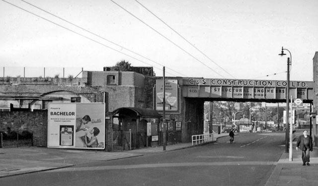
English: Brentford GWR Station (site). View eastward on Brentford High St. The station, on a branch from Southall to Brenford Docks, had been on the left. The passenger station and the service from Southall were closed on 4/5/42, but although Brentford Dock was closed in 1964, goods trains ran to Brentford Town Goods until 7/12/70. |
| Date | |
| Source | From geograph.org.uk |
| Author | Ben Brooksbank |
| Permission (Reusing this file) |
Creative Commons Attribution Share-alike license 2.0 |
| Camera location | | View this and other nearby images on: OpenStreetMap |
|---|
Licensing

|
This image was taken from the Geograph project collection. See this photograph's page on the Geograph website for the photographer's contact details. The copyright on this image is owned by Ben Brooksbank and is licensed for reuse under the Creative Commons Attribution-ShareAlike 2.0 license.
|
This file is licensed under the Creative Commons Attribution-Share Alike 2.0 Generic license.
Attribution: Ben Brooksbank
- You are free:
- to share – to copy, distribute and transmit the work
- to remix – to adapt the work
- Under the following conditions:
- attribution – You must give appropriate credit, provide a link to the license, and indicate if changes were made. You may do so in any reasonable manner, but not in any way that suggests the licensor endorses you or your use.
- share alike – If you remix, transform, or build upon the material, you must distribute your contributions under the same or compatible license as the original.
File history
Click on a date/time to view the file as it appeared at that time.
| Date/Time | Thumbnail | Dimensions | User | Comment | |
|---|---|---|---|---|---|
| current | 13:21, 20 December 2010 | | 640 × 375 (57 KB) | Chevin | == {{int:filedesc}} == {{Information |Description={{en|1=Brentford GWR Station (site) View eastward on Brentford High St. The station, on a branch from Southall to Brenford Docks, had been on the left. The passenger station and the service from Southall w |
File usage
The following pages on the English Wikipedia use this file (pages on other projects are not listed):
Global file usage
The following other wikis use this file:
- Usage on azb.wikipedia.org
- Usage on es.wikipedia.org
- Usage on uk.wikipedia.org
- Usage on www.wikidata.org

_1894854_78770255.jpg¶ms=051.481984_N_-000.313745_E_globe:Earth_type:camera_heading:67.00&language=en)
Recent Comments