
How Can We Help?

Size of this preview: 800 × 460 pixels. Other resolutions: 320 × 184 pixels | 640 × 368 pixels | 1,024 × 588 pixels | 1,280 × 735 pixels | 2,393 × 1,375 pixels.
Original file (2,393 × 1,375 pixels, file size: 1.53 MB, MIME type: image/jpeg)
Summary
| Description |
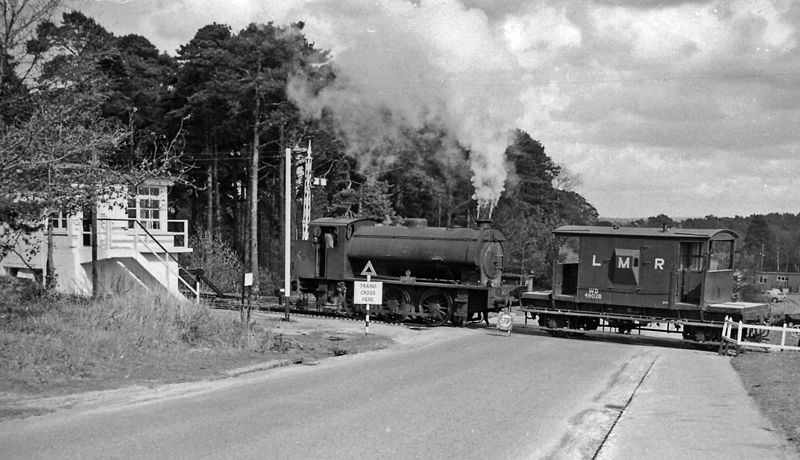
English: Longmoor Military Railway crossing a road at Bordon, 1963. View eastwards near Bordon, probably on the B2131 road - [but I am not quite certain exactly where, as the network of the LMR was complex and has now completely disappeared]. There is a signalbox (freshly painted in Army fashion) on the left, but no crossing-gates. Crossing with a LMR brakevan (British Railways standard 20-ton design, numbered WD 49028) is a typical WD Austerity 0-6-0ST, WD 102 'CAEN'. This is in the latter days of the LMR, as it was all closed by October 1969. |
| Date | |
| Source | From geograph.org.uk |
| Author | Ben Brooksbank |
| Permission (Reusing this file) |
Creative Commons Attribution Share-alike license 2.0 |
| Camera location | | View this and other nearby images on: OpenStreetMap |
|---|
Licensing

|
This image was taken from the Geograph project collection. See this photograph's page on the Geograph website for the photographer's contact details. The copyright on this image is owned by Ben Brooksbank and is licensed for reuse under the Creative Commons Attribution-ShareAlike 2.0 license.
|
This file is licensed under the Creative Commons Attribution-Share Alike 2.0 Generic license.
Attribution: Ben Brooksbank
- You are free:
- to share – to copy, distribute and transmit the work
- to remix – to adapt the work
- Under the following conditions:
- attribution – You must give appropriate credit, provide a link to the license, and indicate if changes were made. You may do so in any reasonable manner, but not in any way that suggests the licensor endorses you or your use.
- share alike – If you remix, transform, or build upon the material, you must distribute your contributions under the same or compatible license as the original.
File history
Click on a date/time to view the file as it appeared at that time.
| Date/Time | Thumbnail | Dimensions | User | Comment | |
|---|---|---|---|---|---|
| current | 09:52, 8 January 2013 | | 2,393 × 1,375 (1.53 MB) | Chevin | == {{int:filedesc}} == {{Information |Description={{en|1='''Longmoor Military Railway crossing road at Bordon, 1963.'''<br/> View eastward near Bordon, probably on the B2131 road - [but I am not quite certain exactly where as the network of the LMR wa... |
File usage
The following pages on the English Wikipedia use this file (pages on other projects are not listed):

Recent Comments