How Can We Help?
You are here:
< Back
![File:Bamberg-Breitenau airfield (04) (cropped).jpg](https://upload.wikimedia.org/wikipedia/commons/thumb/5/53/Bamberg-Breitenau_airfield_%2804%29_%28cropped%29.jpg/800px-Bamberg-Breitenau_airfield_%2804%29_%28cropped%29.jpg)
Size of this preview: 800 × 352 pixels. Other resolutions: 320 × 141 pixels | 640 × 282 pixels | 1,024 × 451 pixels | 1,280 × 564 pixels | 2,570 × 1,132 pixels.
Original file (2,570 × 1,132 pixels, file size: 3.34 MB, MIME type: image/jpeg)
Summary
DescriptionBamberg-Breitenau airfield (04) (cropped).jpg |
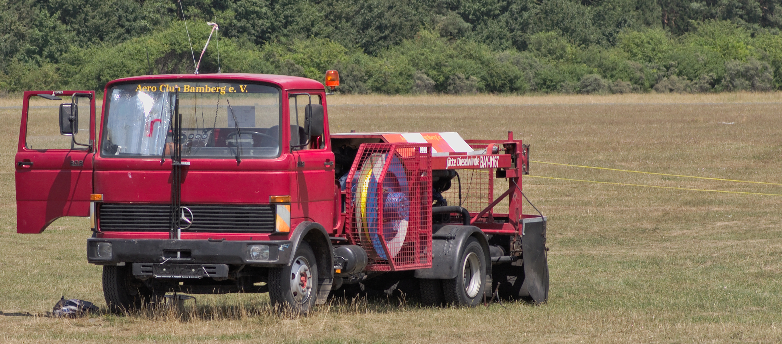
English: Bamberg-Breitenau airfield, formerly Bamberg US Airfield (ICAO: EDQA): Winch for wire-launching gliders.
Deutsch: Flugplatz Bamberg-Breitenau: Startwinde für Segelflugzeuge. |
|||
Date | ||||
Source | Own work | |||
Author | El Grafo | |||
Other versions |
|
Camera location | 49° 54′ 58.24″ N, 10° 54′ 25.19″ E ![]() | View this and other nearby images on: OpenStreetMap | ![]() |
---|
Licensing
El Grafo, the copyright holder of this work, hereby publishes it under the following license:
![w:en:Creative Commons](https://upload.wikimedia.org/wikipedia/commons/thumb/7/79/CC_some_rights_reserved.svg/90px-CC_some_rights_reserved.svg.png)
![attribution](https://upload.wikimedia.org/wikipedia/commons/thumb/1/11/Cc-by_new_white.svg/24px-Cc-by_new_white.svg.png)
![share alike](https://upload.wikimedia.org/wikipedia/commons/thumb/d/df/Cc-sa_white.svg/24px-Cc-sa_white.svg.png)
This file is licensed under the Creative Commons Attribution-Share Alike 4.0 International license.
Attribution: © El Grafo / CC-BY-SA-4.0
- You are free:
- to share – to copy, distribute and transmit the work
- to remix – to adapt the work
- Under the following conditions:
- attribution – You must give appropriate credit, provide a link to the license, and indicate if changes were made. You may do so in any reasonable manner, but not in any way that suggests the licensor endorses you or your use.
- share alike – If you remix, transform, or build upon the material, you must distribute your contributions under the same or compatible license as the original.
Captions
Add a one-line explanation of what this file represents
Items portrayed in this file
depicts
creator
some value
author name string: El Grafo
Wikimedia username: El Grafo
copyright status
copyrighted
copyright license
Creative Commons Attribution-ShareAlike 4.0 International
inception
11 July 2015
coordinates of the point of view
49°54'58.23601"N, 10°54'25.18801"E
source of file
original creation by uploader
captured with
Pentax K-5
SMC Pentax-D FA 100mm F2.8 Macro WR
exposure time
0.01 second
f-number
8
focal length
100 millimetre
ISO speed
100
media type
image/jpeg
instance of
photograph
checksum
00c67aed922f4198e2bac3e2ee6ebae3ab1ba17c
determination method: SHA-1
data size
3,499,110 byte
height
1,132 pixel
width
2,570 pixel
File history
Click on a date/time to view the file as it appeared at that time.
Date/Time | Thumbnail | Dimensions | User | Comment | |
---|---|---|---|---|---|
current | 23:15, 9 May 2020 | ![]() | 2,570 × 1,132 (3.34 MB) | NiD.29 | File:Bamberg-Breitenau airfield (04).jpg cropped 10 % horizontally, 30 % vertically using CropTool with precise mode. |
File usage
The following pages on the English Wikipedia use this file (pages on other projects are not listed):
Metadata
This file contains additional information, probably added from the digital camera or scanner used to create or digitize it.
If the file has been modified from its original state, some details may not fully reflect the modified file.
Camera manufacturer | PENTAX |
---|---|
Camera model | PENTAX K-5 |
Author | El Grafo |
Copyright holder | El Grafo (CC-BY-SA 4.0) |
Exposure time | 1/100 sec (0.01) |
F-number | f/8 |
ISO speed rating | 100 |
Date and time of data generation | 13:23, 11 July 2015 |
Lens focal length | 100 mm |
Latitude | 49° 54′ 58.24″ N |
Longitude | 10° 54′ 25.19″ E |
Altitude | 244.3 meters above sea level |
Width | 2,856 px |
Height | 1,606 px |
Horizontal resolution | 300 dpi |
Vertical resolution | 300 dpi |
Software used | LightZone |
File change date and time | 13:23, 11 July 2015 |
Exposure Program | Aperture priority |
Exif version | 2.2 |
Date and time of digitizing | 13:23, 11 July 2015 |
Exposure bias | 0 |
Metering mode | Center weighted average |
Flash | Flash did not fire, compulsory flash suppression |
Sensing method | One-chip color area sensor |
Custom image processing | Normal process |
Exposure mode | Auto exposure |
White balance | Auto white balance |
Focal length in 35 mm film | 150 mm |
Scene capture type | Standard |
Contrast | Normal |
Saturation | Normal |
Sharpness | Normal |
Subject distance range | Distant view |
GPS time (atomic clock) | 11:23 |
Satellites used for measurement | 08 |
Receiver status | Measurement in progress |
Measurement mode | 3-dimensional measurement |
Speed unit | Kilometers per hour |
Speed of GPS receiver | 0.03 |
Reference for direction of movement | True direction |
Direction of movement | 31.12 |
Reference for direction of image | True direction |
Direction of image | 14.09 |
Geodetic survey data used | WGS-84 |
GPS date | 11 July 2015 |
GPS tag version | 0.0.3.2 |
Categories
-
Annuals36
-
Bulbs, Corms & Tubers41
-
Ferns27
-
Fruits3
-
Garden Plants23
-
Grasses26
-
Herb17
-
Insects1
-
Mammals1
-
Midwest Native Plants0
-
Northeast Native Plants112
-
Perennials123
-
Rose1
-
Shrubs47
-
Trees112
-
Tropical Plants53
-
Upland Birds5
-
Vines18
-
Viola Tricolor1
-
Water Gardening & Plants9
-
Waterfowl0
-
Wetland Birds0
-
Wetland Plants4
-
Wildbirds172
-
Wildflowers1
-
Woodland Plants29
Table of Contents
Recent Comments