
How Can We Help?

Size of this preview: 702 × 599 pixels. Other resolutions: 281 × 240 pixels | 562 × 480 pixels | 900 × 768 pixels | 1,047 × 894 pixels.
Original file (1,047 × 894 pixels, file size: 90 KB, MIME type: image/png)
Summary
| Description |
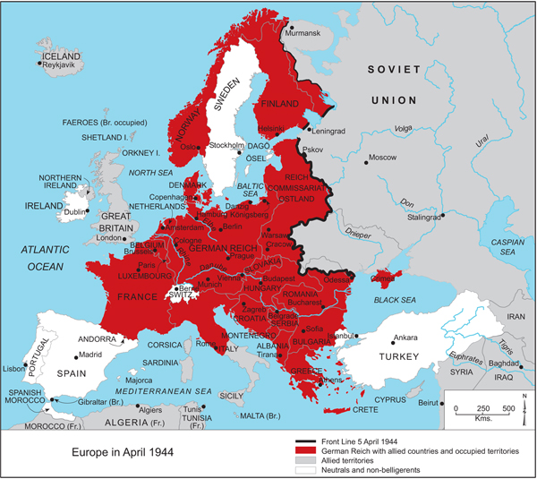
English: Axis occupation and partition of Yugoslavia in World War II. Srpskohrvatski / српскохрватски: Osovinska okupacija i podijela Jugoslavije u Drugom svijetskom ratu. |
| Source | derived from File:Fascist occupation of yugoslavia.png |
| Author |
DIREKTOR for derivative PANONIAN for primary map |
| Other versions |
   |
Licensing
self-made map by user:DIREKTOR
| I, the copyright holder of this work, release this work into the public domain. This applies worldwide. In some countries this may not be legally possible; if so: I grant anyone the right to use this work for any purpose, without any conditions, unless such conditions are required by law. |
References
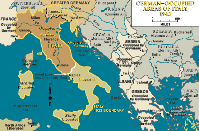
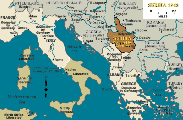
References for general political situation in 1943-1944:
- http://germanhistorydocs.ghi-dc.org/images/English_map_5_bh-edit.jpg
- http://www.ushmm.org/lcmedia/map/lc/image/eur66830.gif
- http://www.ushmm.org/lcmedia/map/lc/image/ita76030.gif
- http://www.ushmm.org/lcmedia/map/lc/image/cro19030.gif
- http://www.ushmm.org/lcmedia/map/lc/image/ser19030.gif
- http://www.leksikon-yu-mitologije.net/files/swedish.jpg[dead link]
- http://people.mail2me.com.au/sljeme/zemljopis_files/image016.jpg
- http://people.mail2me.com.au/sljeme/zemljopis_files/image014.jpg
File history
Click on a date/time to view the file as it appeared at that time.
| Date/Time | Thumbnail | Dimensions | User | Comment | |
|---|---|---|---|---|---|
| current | 11:31, 8 May 2012 | | 1,047 × 894 (90 KB) | DIREKTOR | Further |
| 11:29, 8 May 2012 |  | 1,047 × 894 (90 KB) | DIREKTOR | Label fixes | |
| 06:03, 11 September 2011 |  | 1,047 × 894 (90 KB) | DIREKTOR | ||
| 06:02, 11 September 2011 |  | 1,047 × 894 (133 KB) | DIREKTOR | Demarcation line | |
| 16:33, 8 August 2011 |  | 1,047 × 894 (90 KB) | DIREKTOR | Serbia label | |
| 09:49, 23 June 2011 |  | 1,047 × 894 (94 KB) | DIREKTOR | Reverted to version as of 12:45, 8 June 2011 | |
| 16:58, 14 June 2011 |  | 1,047 × 894 (89 KB) | WhiteWriter | User dont want to discuss on talk, and map is unsourced, unreferenced, and unrelated to all relevant wiki pages. | |
| 12:45, 8 June 2011 |  | 1,047 × 894 (94 KB) | DIREKTOR | Further color fixes. | |
| 12:41, 8 June 2011 |  | 1,047 × 894 (93 KB) | DIREKTOR | Small color fix. | |
| 12:33, 8 June 2011 |  | 1,047 × 894 (93 KB) | DIREKTOR | Reverted to version as of 16:25, 1 June 2011 |
File usage
The following pages on the English Wikipedia use this file (pages on other projects are not listed):
Global file usage
The following other wikis use this file:
- Usage on ar.wikipedia.org
- Usage on el.wikipedia.org
- Usage on en.wikibooks.org
- Usage on es.wikipedia.org
- Usage on ja.wikipedia.org
- Usage on mk.wikipedia.org
- Usage on ms.wikipedia.org
- Usage on pl.wikipedia.org
- Usage on pt.wikipedia.org
- Usage on ru.wikipedia.org
- Usage on sq.wikipedia.org
- Usage on th.wikipedia.org
- Usage on uk.wikipedia.org
- Usage on vi.wikipedia.org
- Usage on www.wikidata.org
- Usage on zh.wikipedia.org

Recent Comments