
How Can We Help?
Size of this preview: 800 × 400 pixels. Other resolutions: 320 × 160 pixels | 845 × 422 pixels.
Original file (845 × 422 pixels, file size: 15 KB, MIME type: image/gif, 0.1 s)
Summary
| Description |
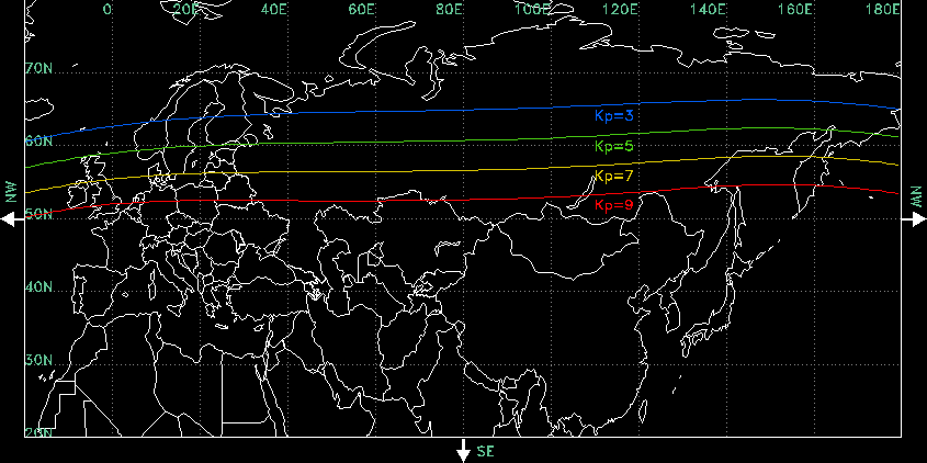
English: This map shows the midnight equatorward boundary of the aurora phenomena at different levels of geomagnetic activity. A Kp=3 represents very low geomagnetic activity, while a Kp=9 represents a very high level. |
| Date | |
| Source | http://www.swpc.noaa.gov/Aurora/index.html#kpmaps |
| Author | NOAA National Weather Service Space Environment Center, Boulder, Colorado, USA |
Licensing
This image is in the public domain because it contains materials that originally came from the U.S. National Oceanic and Atmospheric Administration, taken or made as part of an employee's official duties.
|
File history
Click on a date/time to view the file as it appeared at that time.
| Date/Time | Thumbnail | Dimensions | User | Comment | |
|---|---|---|---|---|---|
| current | 19:10, 28 February 2014 | | 845 × 422 (15 KB) | Scanmap | removing irrelevant information from former context, moving credits to file description, crop to fit content |
| 22:11, 28 October 2011 |  | 850 × 425 (17 KB) | Darkest tree |
File usage
The following pages on the English Wikipedia use this file (pages on other projects are not listed):
Global file usage
The following other wikis use this file:
- Usage on bg.wikipedia.org
- Usage on es.wikipedia.org
- Usage on hi.wikipedia.org
- Usage on ja.wikipedia.org
- Usage on ko.wikipedia.org
- Usage on vi.wikipedia.org
- Usage on zh.wikipedia.org

Recent Comments