
How Can We Help?
No higher resolution available.
4_Ceredigion.png (350 × 418 pixels, file size: 164 KB, MIME type: image/png)
Summary
| Description |
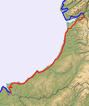
English: 4 Ceredigion - The Wales Coast Path goes around the coastline of Wales. It can be divided into sections or shorter paths |
| Date | |
| Source | File:Wales_relief_location_map.jpg |
| Author | Nilfanion, created using Ordnance Survey data (mod. by Victuallers) |
This image is a derivative work of the following images:
- File:Wales relief location map.jpg
Licensing
This file is licensed under the Creative Commons Attribution-Share Alike 3.0 Unported license.
- You are free:
- to share – to copy, distribute and transmit the work
- to remix – to adapt the work
- Under the following conditions:
- attribution – You must give appropriate credit, provide a link to the license, and indicate if changes were made. You may do so in any reasonable manner, but not in any way that suggests the licensor endorses you or your use.
- share alike – If you remix, transform, or build upon the material, you must distribute your contributions under the same or compatible license as the original.
File history
Click on a date/time to view the file as it appeared at that time.
| Date/Time | Thumbnail | Dimensions | User | Comment | |
|---|---|---|---|---|---|
| current | 15:46, 3 July 2013 | | 350 × 418 (164 KB) | Victuallers | User created page with UploadWizard |
File usage
The following pages on the English Wikipedia use this file (pages on other projects are not listed):
Global file usage
The following other wikis use this file:
- Usage on ca.wikipedia.org
- Usage on de.wikipedia.org
- Usage on es.wikipedia.org
- Usage on gd.wikipedia.org
- Usage on nl.wikipedia.org
- Usage on no.wikipedia.org
- Usage on simple.wikipedia.org

Recent Comments