
How Can We Help?

Size of this PNG preview of this SVG file: 661 × 600 pixels. Other resolutions: 264 × 240 pixels | 529 × 480 pixels | 846 × 768 pixels | 1,128 × 1,024 pixels | 2,257 × 2,048 pixels | 3,256 × 2,955 pixels.
Original file (SVG file, nominally 3,256 × 2,955 pixels, file size: 252 KB)
Summary
| Description |
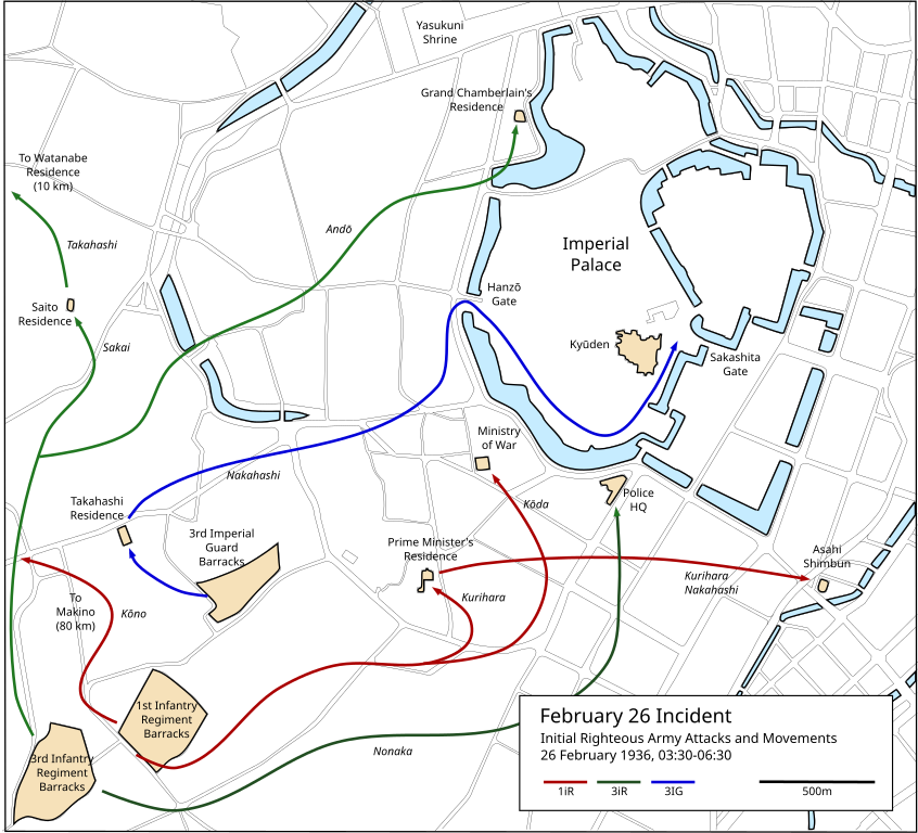
English: Map of the initial attacks and movements of the rebel officers during the 2-26 Incident. |
| Date | |
| Source | Self-made. Map of Tokyo largely based on 1946 US military aerial photography found at http://archive.gsi.go.jp/airphoto/. Data on attacks mainly from Chaen Yoshio, Zusetsu 2/26 Jiken, Nihon Tosho Center, 2001. |
| Author | Cckerberos |
Licensing
I, the copyright holder of this work, hereby publish it under the following licenses:
This file is licensed under the Creative Commons Attribution-Share Alike 3.0 Unported license.
- You are free:
- to share – to copy, distribute and transmit the work
- to remix – to adapt the work
- Under the following conditions:
- attribution – You must give appropriate credit, provide a link to the license, and indicate if changes were made. You may do so in any reasonable manner, but not in any way that suggests the licensor endorses you or your use.
- share alike – If you remix, transform, or build upon the material, you must distribute your contributions under the same or compatible license as the original.

|
Permission is granted to copy, distribute and/or modify this document under the terms of the GNU Free Documentation License, Version 1.2 or any later version published by the Free Software Foundation; with no Invariant Sections, no Front-Cover Texts, and no Back-Cover Texts. A copy of the license is included in the section entitled GNU Free Documentation License. |
You may select the license of your choice.
File history
Click on a date/time to view the file as it appeared at that time.
| Date/Time | Thumbnail | Dimensions | User | Comment | |
|---|---|---|---|---|---|
| current | 11:43, 25 February 2013 | | 3,256 × 2,955 (252 KB) | Cckerberos | Added white background. |
| 11:40, 25 February 2013 |  | 3,256 × 2,955 (252 KB) | Cckerberos | {{Information |Description ={{en|1=Map of the initial attacks and movements of the rebel officers during the 2-26 Incident. }} |Source ={{own}} |Author =Cckerberos |Date =2013-02-25 |Permission = |ot... |
File usage
The following pages on the English Wikipedia use this file (pages on other projects are not listed):
Global file usage
The following other wikis use this file:
- Usage on azb.wikipedia.org
- Usage on de.wikipedia.org
- Usage on id.wikipedia.org
- Usage on it.wikipedia.org
- Usage on www.wikidata.org

Recent Comments