
Original file (4,000 × 1,302 pixels, file size: 1.5 MB, MIME type: image/jpeg)
| Kumgangsan. | ||||||
|---|---|---|---|---|---|---|
| Artist | ||||||
| Title |
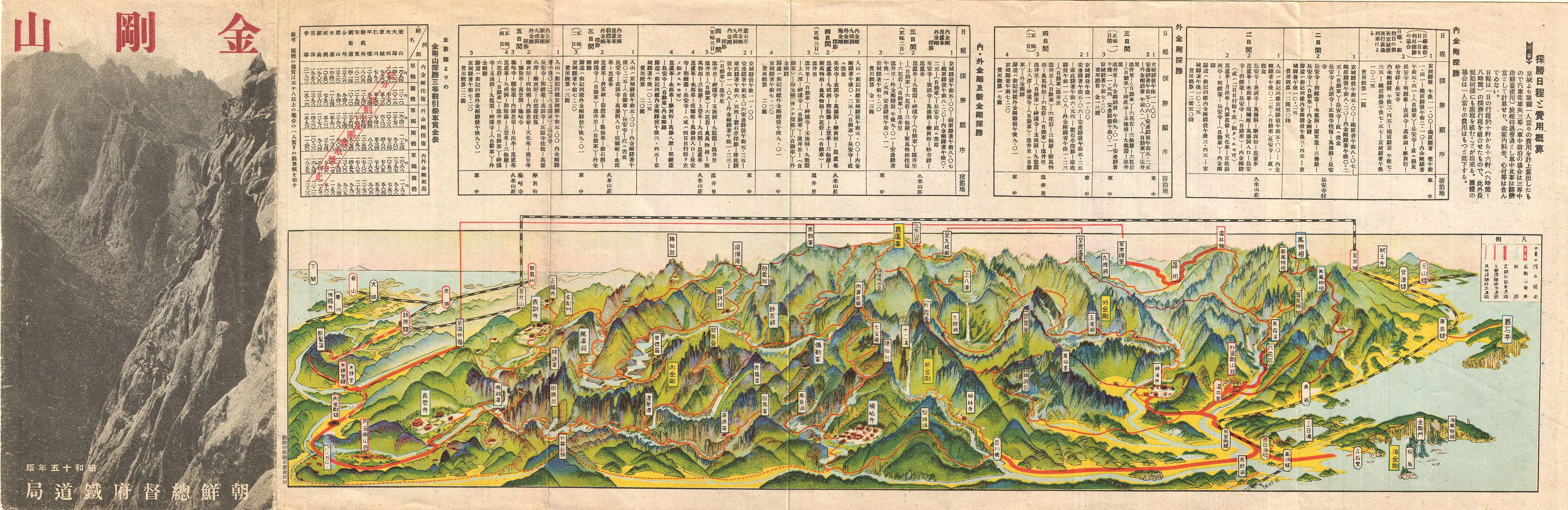
Kumgangsan. |
|||||
| Description |
English: An extremely attractive 1939 or Showa 14 panoramic view map of Kumgangsan or Diamond Mountain, North Korea. Also known as Mount Kumgang, Diamond Mountain is an important tourist destination in North Korea. Diamond Mountain is one of the few areas in North Korea that is open to foreign tourism and regularly visited by international travelers. The mountain is known for is dramatic views and stunning natural beauty. This uncommon type of map evolved out of traditional Japanese view-style cartography and began to appear in Japan, Taiwan, and Korea in the early 20th century. Generally speaking such maps coincided with the development of railroad lines throughout the once vast Dai Nippon Teikoku or Japanese Empire. It is a distinctive style full of artistic flourish that at the same time performs a practical function. This particular example is both relatively early and exceptionally beautiful. It was printed via a multi-color lithographic process with delicately shaded tones and a easily comprehensible intuitive design. Shows villages, famous sights, roadways, and rail lines. Folds into itself, accordion style, with an photographic cover depicting Diamond Mountain at the left end. Verso features additional Japanese text and a smaller transportation map. |
|||||
| Date | 1939 or Showa 14 | |||||
| Dimensions | height: 7 in (17.7 cm); width: 21 in (53.3 cm) | |||||
| Accession number |
Geographicus link: DiamondMountain-showa14-1939 |
|||||
| Source/Photographer |
|
|||||
| Permission (Reusing this file) |
|
|||||
| Other versions | ||||||
| Object location | | View this and other nearby images on: OpenStreetMap |
|---|
File history
Click on a date/time to view the file as it appeared at that time.
| Date/Time | Thumbnail | Dimensions | User | Comment | |
|---|---|---|---|---|---|
| current | 02:41, 24 March 2011 | 4,000 × 1,302 (1.5 MB) | BotMultichillT | {{subst:User:Multichill/Geographicus |link=http://www.geographicus.com/P/AntiqueMap/DiamondMountain-showa14-1939 |product_name=1939 Showa 14 Panorama Map of Diamond Mountain, Kumgangsan, Korea |map_title=Kumgangsan. |description=An extremely attractive 1 |
File usage
Global file usage
The following other wikis use this file:
- Usage on en.wikiquote.org
- Usage on fr.wikipedia.org
- Usage on ja.wikipedia.org
- Usage on ka.wikipedia.org
- Usage on tl.wikipedia.org
- Usage on uk.wikipedia.org

Recent Comments