
How Can We Help?

Size of this preview: 800 × 533 pixels. Other resolutions: 320 × 213 pixels | 640 × 427 pixels | 1,024 × 683 pixels | 1,280 × 853 pixels | 3,000 × 2,000 pixels.
Original file (3,000 × 2,000 pixels, file size: 1.88 MB, MIME type: image/jpeg)
Summary
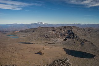
| Description | Mount Werth (908 m or 2,979 ft), Grande Terre, Kerguelen Archipelago. View from Crozier Mountain with Mount Ross in the background. |
| Date | Taken on 24 February 2018, 11:34:53 |
| Source | Own work |
| Author | Armand Patoir (talk · contribs) |
| Camera location | | View this and other nearby images on: OpenStreetMap |
|---|
Licensing
I, the copyright holder of this work, hereby publish it under the following license:
This file is licensed under the Creative Commons Attribution-Share Alike 4.0 International license.
- You are free:
- to share – to copy, distribute and transmit the work
- to remix – to adapt the work
- Under the following conditions:
- attribution – You must give appropriate credit, provide a link to the license, and indicate if changes were made. You may do so in any reasonable manner, but not in any way that suggests the licensor endorses you or your use.
- share alike – If you remix, transform, or build upon the material, you must distribute your contributions under the same or compatible license as the original.
This picture has been imported as part of the Photographiez les Outre-Mer contest, organized by Wikimédia France, the French Development Agency and the Ministry of Overseas France.
|
File history
Click on a date/time to view the file as it appeared at that time.
| Date/Time | Thumbnail | Dimensions | User | Comment | |
|---|---|---|---|---|---|
| current | 10:59, 31 August 2018 | | 3,000 × 2,000 (1.88 MB) | Armand.patoir | User created page with UploadWizard |
File usage
The following pages on the English Wikipedia use this file (pages on other projects are not listed):
Global file usage
The following other wikis use this file:
- Usage on ceb.wikipedia.org
- Usage on de.wikipedia.org
- Usage on fr.wikipedia.org
- Usage on lfn.wikipedia.org
- Usage on sr.wikipedia.org

_devant_le_Ross.jpg¶ms=-49.294688_N_0069.982080_E_globe:Earth_type:camera__&language=en)
Recent Comments