How Can We Help?
You are here:
< Back

070818_T_Chausuyama_Kofun_aerial.jpg(454 × 454 pixels, file size: 252 KB, MIME type: image/jpeg)

Summary

Description

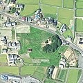
富田茶臼山古墳上空の空中写真。

国土交通省撮影の空中写真CSI20071-C20-54を使用。
Date
Source 国土地理院地図・空中写真閲覧サービス
Author 国土交通省国土地理院
Camera location34° 15′ 35.7″ N, 134° 14′ 38.58″ E Kartographer map based on OpenStreetMap.View this and other nearby images on: OpenStreetMapinfo

Licensing

© The copyright holder of this file, the Ministry of Land, Infrastructure, Transport and Tourism of Japan, allows anyone to use it for any purpose, provided that the copyright holder is properly attributed. Redistribution, derivative work, commercial use, and all other use is permitted.
Attribution:
Copyright © National Land Image Information (Color Aerial Photographs), Ministry of Land, Infrastructure, Transport and Tourism

Notice
This image is copyrighted by the Ministry of Land, Infrastructure, Transport and Tourism of Japan. For terms of use, see the stipulation to use of National Land Information (in Japanese) and message from MLIT (in Japanese and English). When you display this image on an article, include the following phrase in the description: "Made based on National Land Image Information (Color Aerial Photographs), Ministry of Land, Infrastructure, Transport and Tourism".

Captions

Add a one-line explanation of what this file represents

Items portrayed in this file

depicts

inception

18 August 2007

coordinates of the point of view

34°15'35.701"N, 134°14'38.580"E

exposure time

0.0025 second

f-number

5.6

focal length

153.76 millimetre

media type

image/jpeg

checksum

21468263df7b854f31b2f7ca3ea145b40fda9996

determination method: SHA-1

data size

257,626 byte

height

454 pixel

width

454 pixel

File history

Click on a date/time to view the file as it appeared at that time.

Date/TimeThumbnailDimensionsUserComment
current14:45, 12 November 2021Thumbnail for version as of 14:45, 12 November 2021454 × 454 (252 KB)名古屋太郎{{Information |Description= 富田茶臼山古墳上空の空中写真。 国土交通省撮影の空中写真CSI20071-C20-54を使用。 |Source= 国土地理院地図・空中写真閲覧サービス |Date= 2007-08-18 |Author= 国土交通省国土地理院 |Permission= |other_versions= }} Category:Tomida Chausuyama Kofun Category:Taken with Leica Wild Heerbrugg RC30
The following pages on the English Wikipedia use this file (pages on other projects are not listed):

Global file usage

The following other wikis use this file:

Metadata

Categories
Table of Contents