How Can We Help?
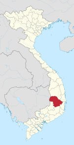
Buôn Hồ is a town (thị xã) of Đắk Lắk province in the Central Highlands of Vietnam. Until December 2008, the town was the southern portion of Krông Búk District.
Buôn Hồ is subdivided into seven wards (phường) and five communes (xã):
- Wards: Đạt Hiếu, An Lạc, An Bình, Thiện An, Đoàn Kết, Thống Nhất, Bình Tân
- Communes: Ea Siên, Ea Drông, Ea Blang, Bình Thuận, Cư Bao
As of December 2008, Buôn Hồ had a population of 101,554. The district covers an area of 282.06 km2.
Climate
| Climate data for Buôn Hồ, elevation 700 m (2,300 ft) | |||||||||||||
|---|---|---|---|---|---|---|---|---|---|---|---|---|---|
| Month | Jan | Feb | Mar | Apr | May | Jun | Jul | Aug | Sep | Oct | Nov | Dec | Year |
| Record high °C (°F) | 31.3 (88.3) |
34.2 (93.6) |
36.1 (97.0) |
36.6 (97.9) |
35.6 (96.1) |
32.9 (91.2) |
31.5 (88.7) |
31.5 (88.7) |
30.8 (87.4) |
30.0 (86.0) |
30.5 (86.9) |
29.8 (85.6) |
36.6 (97.9) |
| Mean daily maximum °C (°F) | 24.1 (75.4) |
26.8 (80.2) |
29.4 (84.9) |
30.9 (87.6) |
30.0 (86.0) |
28.2 (82.8) |
27.5 (81.5) |
27.1 (80.8) |
27.1 (80.8) |
26.3 (79.3) |
24.9 (76.8) |
23.3 (73.9) |
27.1 (80.8) |
| Daily mean °C (°F) | 18.8 (65.8) |
20.4 (68.7) |
22.6 (72.7) |
24.3 (75.7) |
24.3 (75.7) |
23.5 (74.3) |
22.9 (73.2) |
22.7 (72.9) |
22.6 (72.7) |
22.0 (71.6) |
20.8 (69.4) |
19.1 (66.4) |
22.0 (71.6) |
| Mean daily minimum °C (°F) | 16.0 (60.8) |
16.8 (62.2) |
18.5 (65.3) |
20.3 (68.5) |
20.9 (69.6) |
20.6 (69.1) |
20.2 (68.4) |
20.2 (68.4) |
20.1 (68.2) |
19.5 (67.1) |
18.5 (65.3) |
16.8 (62.2) |
19.0 (66.2) |
| Record low °C (°F) | 8.8 (47.8) |
11.1 (52.0) |
10.1 (50.2) |
15.8 (60.4) |
16.5 (61.7) |
18.0 (64.4) |
17.1 (62.8) |
17.7 (63.9) |
17.8 (64.0) |
13.8 (56.8) |
10.5 (50.9) |
8.5 (47.3) |
8.5 (47.3) |
| Average precipitation mm (inches) | 5.3 (0.21) |
6.2 (0.24) |
19.6 (0.77) |
88.6 (3.49) |
189.6 (7.46) |
204.4 (8.05) |
191.8 (7.55) |
261.4 (10.29) |
260.6 (10.26) |
190.5 (7.50) |
110.4 (4.35) |
29.6 (1.17) |
1,558.2 (61.35) |
| Average rainy days | 3.9 | 2.0 | 4.0 | 8.2 | 18.2 | 20.4 | 22.4 | 24.8 | 23.9 | 18.5 | 13.7 | 10.1 | 169.8 |
| Average relative humidity (%) | 84.4 | 79.8 | 76.4 | 76.1 | 81.6 | 86.4 | 88.3 | 89.8 | 89.6 | 89.3 | 88.9 | 88.1 | 84.9 |
| Mean monthly sunshine hours | 229.7 | 233.5 | 257.2 | 242.4 | 232.4 | 206.7 | 199.7 | 174.9 | 157.6 | 157.3 | 156.2 | 167.6 | 2,419.2 |
| Source: Vietnam Institute for Building Science and Technology[1] | |||||||||||||
References
- ^ "Vietnam Institute for Building Science and Technology" (PDF). Retrieved 16 August 2023.
- (in Vietnamese) Government Decree No. 07/NĐ-CP[permanent dead link] enacted on 23 December 2008 by the Government of Vietnam.
12°51′16″N 108°16′13″E / 12.8544°N 108.2703°E


Recent Comments