 |
|---|
|


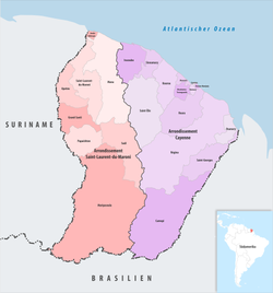
The 3 arrondissements of the Guyane department are:[1]
- Arrondissement of Cayenne (prefecture of the Guyane department: Cayenne), with 10 communes. The population of the arrondissement was 177,716 in 2019.
- Arrondissement of Saint-Laurent-du-Maroni (subprefecture: Saint-Laurent-du-Maroni), with 8 communes. The population of the arrondissement was 96,757 in 2019.
- Arrondissement of Saint-Georges (subprefecture: Saint-Georges), with 4 communes. The population of the arrondissement was 7,205 in 2019. This arrondissement was created by a government decree of October 26, 2022.[2]
History
At the creation of the department of Guyane in 1947, its only arrondissement was Cayenne.[3] The arrondissement of Inini, containing the previously unincorporated inland territory of French Guiana, was created in 1951.[4] In 1969 the arrondissement of Inini was disbanded, and the territory of French Guiana was divided between the arrondissement of Cayenne and the new arrondissement of Saint-Laurent-du-Maroni.[5] In October 2022, the arrondissement of Saint-Georges was created by detaching from the arrondissement of Cayenne 4 communes of the Oyapock River valley bordering Brazil, in order to bring French central state services closer to this area located nearly 200 km from Cayenne.[6]
See also
References
- ^ "Populations légales 2016" (PDF). INSEE. December 2018. Retrieved 2019-10-29.
- ^ Décret n° 2022-1357 du 26 octobre 2022 portant création de l'arrondissement de Saint-Georges (in French) Retrieved 26 March 2023
- ^ Décret n° 47-1018 du 7 juin 1947 relatif à l'organisation départementale et à l'institution préfectorale dans les départements de la Guadeloupe, de la Guyane française, de la Martinique et de la Réunion
- ^ Loi n°51-1098 du 14 septembre 1951
- ^ Décret n°69-261 du 17 mars 1969
- ^ "Création d'une nouvelle sous-préfecture en Guyane à Saint-Georges de l'Oyapock | Mom".


Recent Comments