
How Can We Help?
The Appenzell Alps (German: Appenzeller Alpen) are a mountain range in Switzerland on the northern edge of the Alps. They extend into the cantons of Appenzell Ausserrhoden, Appenzell Innerrhoden and St. Gallen and are bordered by the Glarus Alps to the west and the Rätikon to the south-east.
Sub-ranges
The range is split up into six sub-ranges:
- Alpstein, central group, highest summit: Altmann, 2,435 m
- Alpstein, northern group, highest summit: Säntis, 2,502 m
- Alpstein, southern group, highest summit: Roslen- or Saxerfirst, 2,151 m
- Alviergruppe, highest summit: Gamsberg, 2,385 m
- Churfirsten, highest summit: Hinterrugg, 2,306 m
- Speer - Mattstock, highest summit: Speer, 1,950 m
Geography
Principal summits
The principal summits of the Appenzell Alps are:
- Säntis, 2,502 m
- Girenspitz, 2,448 m
- Altmann, 2,436 m
- Gamsberg, 2,385 m
- Fulfirst, 2,384 m
- Wildhuser Schafberg, 2,373 m
- Wisswand, 2,346 m
- Alvier, 2,343 m
- Gauschla, 2,310 m
- Hinterrugg, 2,306 m
- Brisi, 2,279 m
- Frümsel, 2,267 m
- Zuestoll, 2,235 m
- Margelchopf, 2,163 m
- Silberplatten, 2,158 m
- Hundstein, 2,157 m
- Schibestoll, 2,136 m
- Leistchamm, 2,101 m
- Gamser Rugg, 2,076 m
- Kreuzberge, 2,065 m
- Marwees, 2,056 m
- Lütispitz, 1,987 m
- Speer, 1,950 m
- Mattstock, 1,936 m
- Schäfler, 1,924 m
- Federispitz, 1,865 m
- Gonzen, 1,830 m
- Hoher Kasten, 1,795 m
- Gulmen, 1,789 m
- Stockberg, 1,781 m
- Kronberg, 1,663 m
- Ebenalp, 1,640 m
- Hochalp, 1,521 m
Other interesting summits
Gallery
-
 Säntis from Schwägalp
 -

-
 Summit of Churfirsten
 -

-
 Restaurant Aescher-Wildkirchli near Ebenalp
 -
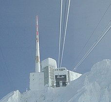 Summit of Säntis


Recent Comments