
How Can We Help?
This is a series of maps showing South African municipalities (local, district, and metro) higlighted within their provinces. This maps are generated by User:Htonl from ESRI Shapefiles from the Municipal Demarcation Board, South Africa archive copy at the Wayback Machine. A Perl script converts the data to a SVG image (which is much less detailed than the original shapefile). If you want a copy of the Perl scripts, leave a message on the talk page.
This page is part of WikiProject South African municipalities on the English Wikipedia. The images here are also categorised under Category:Maps of South African municipalities.
- Maps are also available as part of the
 Wikimedia Atlas of the World project in the Atlas of South Africa.
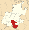
Eastern Cape
-
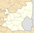
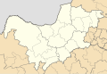
 Blank template

Metro municipalities
-
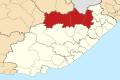
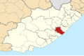
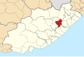
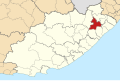
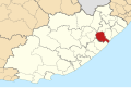
 Nelson Mandela Bay
 -
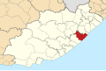
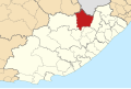
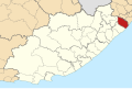
 Buffalo City


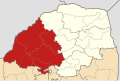
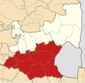
District municipalities
-
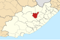
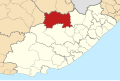
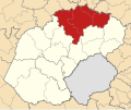
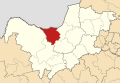
 Sarah Baartman
 -
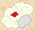
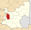
 Amathole
 -
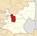
 Chris Hani
 -
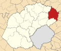
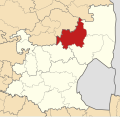
 Joe Gqabi
 -
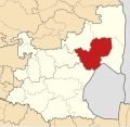
 OR Tambo
 -
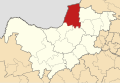
 Alfred Nzo


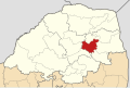
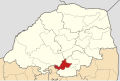
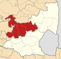
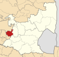
Local municipalities
-
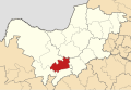
 Dr Beyers Naudé
 -
 Blue Crane Route
 -
 Makana
 -
 Ndlambe
 -
 Sunday's River Valley
 -
 Kouga
Kouga -
 Kou-Kamma
 -
 Mbhashe
 -
 Mnquma
 -
 Great Kei
 -
 Amahlathi
 -
 Ngqushwa
 -
 Raymond Mhlaba
 -
 Inxuba Yethemba
 -
 Intsika Yethu
 -
 Emalahleni
 -
 Engcobo
 -
 Sakhisizwe
 -
 Enoch Mgijima
 -
 Elundini
 -
 Senqu
Senqu -
 Walter Sisulu
 -
 Ingquza Hill
 -
 Port St Johns
 -
 Nyandeni
 -
 Mhlontlo
 -
 King Sabata Dalindyebo
 -
 Matatiele
 -
 Umzimvubu
 -
 Mbizana
 -
 Ntabankulu


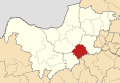
Free State
-
 Blank template

Metro municipality
-
 Mangaung

District municipalities
-
 Xhariep
 -
 Lejweleputswa
 -
 Thabo Mofutsanyana
 -
 Fezile Dabi


Local municipalities
-
 Letsemeng
 -
 Kopanong
 -
 Mohokare
 -
 Masilonyana
 -
 Tokologo
 -
 Tswelopele
 -
 Matjhabeng
 -
 Nala
Nala -
 Setsoto
 -
 Dihlabeng
 -
 Nketoana
 -
 Maluti-a-Phofung
 -
 Phumelela
 -
 Mantsopa
 -
 Moqhaka
 -
 Ngwathe
 -
 Metsimaholo
 -
 Mafube


Gauteng
-
 Blank template
 -
 With English labels


Metro municipalities
-
 Ekurhuleni
 -
 Johannesburg
 -
 Tshwane


District municipalities
-
 Sedibeng
 -
 West Rand


Local municipalities
-
 Emfuleni
 -
 Midvaal
 -
 Lesedi
 -
 Mogale City
 -
 Rand West City
 -
 Merafong City


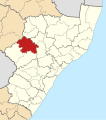
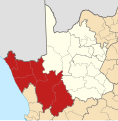
KwaZulu-Natal
-
 Blank template

Metro municipality
-
 eThekwini

District municipalities
-
 Ugu
Ugu -
 uMgungundlovu
 -
 uThukela
 -
 uMzinyathi
 -
 Amajuba
 -
 Zululand
 -
 uMkhanyakude
 -
 King Cetshwayo
 -
 iLembe
 -
 Harry Gwala


Local municipalities
-
 uMdoni
 -
 Umzumbe
 -
 uMuziwabantu
 -
 Ray Nkonyeni
 -
 uMshwathi
 -
 uMngeni
 -
 Mpofana
 -
 Impendle
 -
 Msunduzi
 -
 Mkhambathini
 -
 Richmond
 -
 Okhahlamba
 -
 iNkosi Langalibalele
 -
 Alfred Duma
 -
 Endumeni
 -
 Nquthu
 -
 Msinga
 -
 Umvoti
 -
 Newcastle
 -
 eMadlangeni
 -
 Dannhauser
 -
 eDumbe
 -
 uPhongolo
 -
 Abaqulusi
 -
 Nongoma
 -
 Ulundi
 -
 uMhlabuyalingana
 -
 Jozini
 -
 Mtubatuba
 -
 Big Five Hlabisa
 -
 uMfolozi
 -
 uMhlathuze
 -
 Umlalazi
 -
 Mthonjaneni
 -
 Nkandla
 -
 Mandeni
 -
 KwaDukuza
 -
 Ndwedwe
 -
 Maphumulo
 -
 Greater Kokstad
 -
 Ubuhlebezwe
 -
 Umzimkhulu
 -
 Dr Nkosazana Dlamini Zuma


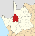
Limpopo
-
 Blank template

District municipalities
-
 Mopani
 -
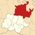
 Vhembe
 -
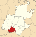
 Capricorn
 -
 Waterberg
 -
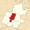
 Sekhukhune


Local municipalities
-
 Greater Giyani
 -
 Greater Letaba
 -
 Greater Tzaneen
 -
 Ba-Phalaborwa
 -
 Maruleng
 -
 Musina
 -
 Thulamela
 -
 Makhado
 -
 Collins Chabane
 -
 Blouberg
 -
 Molemole
 -
 Polokwane
 -
 Lepelle-Nkumpi
 -
 Thabazimbi
 -
 Lephalale
 -
 Bela Bela
 -
 Mogalakwena
 -
 Modimolle/Mookgophong
 -
 Ephraim Mogale
 -
 Elias Motsoaledi
 -
 Makhuduthamaga
 -
 Fetakgomo/Greater Tubatse


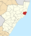
Mpumalanga
-
 Blank template

District municipalities
-
 Gert Sibande
 -
 Nkangala
 -
 Ehlanzeni


Local municipalities
-
 Albert Luthuli
 -
 Msukaligwa
 -
 Mkhondo
 -
 Pixley ka Seme
 -
 Lekwa
Lekwa -
 Dipaleseng
 -
 Govan Mbeki
 -
 Victor Khanye
 -
 Emalahleni
 -
 Steve Tshwete
 -
 Emakhazeni
 -
 Thembisile
 -
 Dr JS Moroka
 -
 Thaba Chweu
 -
 Mbombela
 -
 Nkomazi
 -
 Bushbuckridge


North West
-
 Blank template

District municipalities
-
 Bojanala Platinum
 -
 Ngaka Modiri Molema
 -
 Dr Ruth Segomotsi Mompati
 -
 Dr Kenneth Kaunda


Local municipalities
-
 Moretele
 -
 Madibeng
 -
 Rustenburg
 -
 Kgetlengrivier
 -
 Moses Kotane
 -
 Ratlou
 -
 Tswaing
 -
 Mahikeng
 -
 Ditsobotla
 -
 Ramotshere Moiloa
 -
 Naledi
 -
 Mamusa
 -
 Greater Taung
 -
 Lekwa-Teemane
 -
 Kagisano-Molopo
 -
 Ventersdorp/Tlokwe
 -
 Matlosana
 -
 Maquassi Hills


Northern Cape
-
 Blank template

District municipalities
-
 Namakwa
 -
 Pixley ka Seme
 -
 ZF Mgcawu
 -
 Frances Baard
 -
 John Taolo Gaetsewe


Local municipalities
-
 Richtersveld
 -
 Nama Khoi
 -
 Kamiesberg
 -
 Hantam
 -
 Karoo Hoogland
 -
 Khâi-Ma
 -
 Ubuntu
 -
 Umsobomvu
 -
 Emthanjeni
 -
 Kareeberg
 -
 Renosterberg
 -
 Thembelihle
 -
 Siyathemba
 -
 Siyancuma
 -
 Dawid Kruiper
 -
 !Kai! Garib
 -
 !Kheis
 -
 Tsantsabane
 -
 Kgatelopele
 -
 Sol Plaatjie
 -
 Dikgatlong
 -
 Magareng
 -
 Phokwane
 -
 Joe Morolong
 -
 Ga-Segonyana
 -
 Gamagara


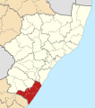
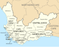
Western Cape
-
 Blank template
 -
 With English labels


Metro municipality
-
 City of Cape Town

District municipalities
-
 West Coast
 -
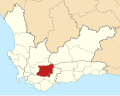
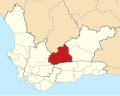
 Cape Winelands
 -
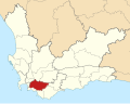
 Overberg
 -
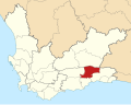
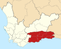 Garden Route
 -
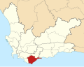
 Central Karoo


Local municipalities
-
 Matzikama
 -
 Cederberg
 -
 Bergrivier
 -
 Saldanha Bay
 -
 Swartland
 -
 Witzenberg
 -
 Drakenstein
 -
 Stellenbosch
 -
 Breede Valley
 -
 Langeberg
 -
 Theewaterskloof
 -
 Overstrand
 -
 Cape Agulhas
 -
 Swellendam
 -
 Kannaland
 -
 Hessequa
 -
 Mossel Bay
 -
 George
 -
 Oudtshoorn
 -
 Bitou
Bitou -
 Knysna
 -
 Laingsburg
 -
 Prince Albert
 -
 Beaufort West


Recent Comments