
How Can We Help?

Size of this preview: 791 × 599 pixels. Other resolutions: 317 × 240 pixels | 634 × 480 pixels | 991 × 751 pixels.
Original file (991 × 751 pixels, file size: 628 KB, MIME type: image/jpeg)
Captions
Captions
Add a one-line explanation of what this file represents
Summary
| Description |
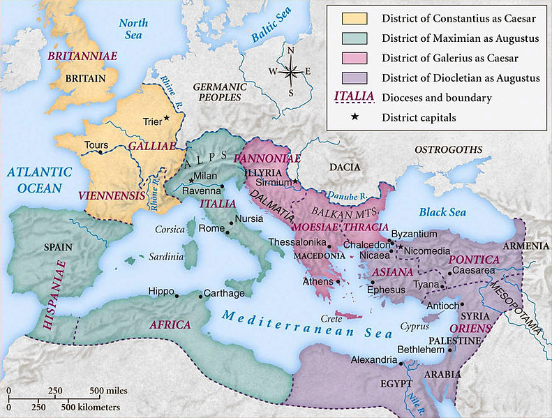
Català: Imperi Romà durant l'època de la Tetrarquia. Deutsch: Karte des Römischen Reichs während der ersten Tetrarchie (ab 293 n.Chr) English: Historic map of Roman Empire during the first tetrarchy Français : Carte de l'empire romain sous la première tétrarchie (293) Português do Brasil: Império Romano à época da Tetrarquia Русский: Карта Римской империи во времена первой тетрархии. 中文: 罗马帝国第一次东西分治的地图(自公元293年起) עברית : מפה של האימפריה הרומאית בתקופת הטטררכיה הראשונה. |
||||||
| Date | |||||||
| Source | Coppermine Photo Gallery | ||||||
| Author | Coppermine Photo Gallery | ||||||
| Permission (Reusing this file) |
Coppermine Photo Gallery (CPG) is an open source project released under the GNU/GPL terms. | ||||||
| Other versions |
|


Licensing

|
Permission is granted to copy, distribute and/or modify this document under the terms of the GNU Free Documentation License, Version 1.2 or any later version published by the Free Software Foundation; with no Invariant Sections, no Front-Cover Texts, and no Back-Cover Texts. A copy of the license is included in the section entitled GNU Free Documentation License. |
| This file is licensed under the Creative Commons Attribution-Share Alike 3.0 Unported license. | ||
| ||
| This licensing tag was added to this file as part of the GFDL licensing update. |
File history
Click on a date/time to view the file as it appeared at that time.
| Date/Time | Thumbnail | Dimensions | User | Comment | |
|---|---|---|---|---|---|
| current | 11:36, 8 October 2013 | | 991 × 751 (628 KB) | DIREKTOR (talk | contribs) | Cropped frame |
| 11:23, 17 August 2008 |  | 1,000 × 760 (196 KB) | Brane Blokar (talk | contribs) | {{Information |Description=English: historic map of Roman Empire during the first tetrarchy |Source=Coppermine Photo Gallery |Date=2008-18-17 |Author=Coppermine Photo Gallery |Permission=Coppermine Photo Gallery (CPG) is an open source project released un |
You cannot overwrite this file.
File usage on Commons
The following 15 pages use this file:
- Atlas of Albania
- Atlas of Bosnia and Herzegovina
- Atlas of Kosovo
- Atlas of Republika Srpska
- Atlas of Serbia
- Atlas of Vojvodina
- File:Roman Tetrarchy map - RU.svg
- File:Römische Tetrarchie-es.svg
- File:Römische Tetrarchie-fr.svg
- File:Römische Tetrarchie-pt.svg
- File:Römische Tetrarchie-zh.svg
- File:Römische Tetrarchie.svg
- File:Tetrarchy map3.jpg
- File:Tetrarchy map3 Heb.jpg
- Template:Other versions/Roman Tetrarchy
File usage on other wikis
The following other wikis use this file:
- Usage on af.wikipedia.org
- Usage on ast.wikipedia.org
- Usage on be.wikipedia.org
- Usage on bg.wikipedia.org
- Usage on cs.wikipedia.org
- Usage on da.wikipedia.org
- Usage on el.wikipedia.org
- Usage on en.wikipedia.org
- Diocletian
- Tetrarchy
- 293
- Outline of ancient Rome
- Nicomedia
- List of Roman civil wars and revolts
- Fall of the Western Roman Empire
- Praetorian prefecture
- Diocletianic Persecution
- Later Roman Empire
- Byzantine Empire
- History of the Roman Empire
- History of the Byzantine Empire
- Timeline of Eastern Orthodoxy in Greece (33–717)
- Diocese of Moesiae
- Classical Anatolia
- Geopolitics of the Roman Empire
- User:Bridgerlyman/sandbox
- User:Falcaorib/Ancient Empires (150-500 AD)
- User:Falcaorib/Europe
- Usage on en.wikibooks.org
- Usage on et.wikipedia.org
- Usage on eu.wikipedia.org
- Usage on fa.wikipedia.org
- Usage on id.wikipedia.org
- Usage on it.wikipedia.org
- Usage on ja.wikipedia.org
View more global usage of this file.

Recent Comments