
Original file (2,038 × 1,828 pixels, file size: 2 MB, MIME type: image/png)
Captions
Captions
Summary
| Description |
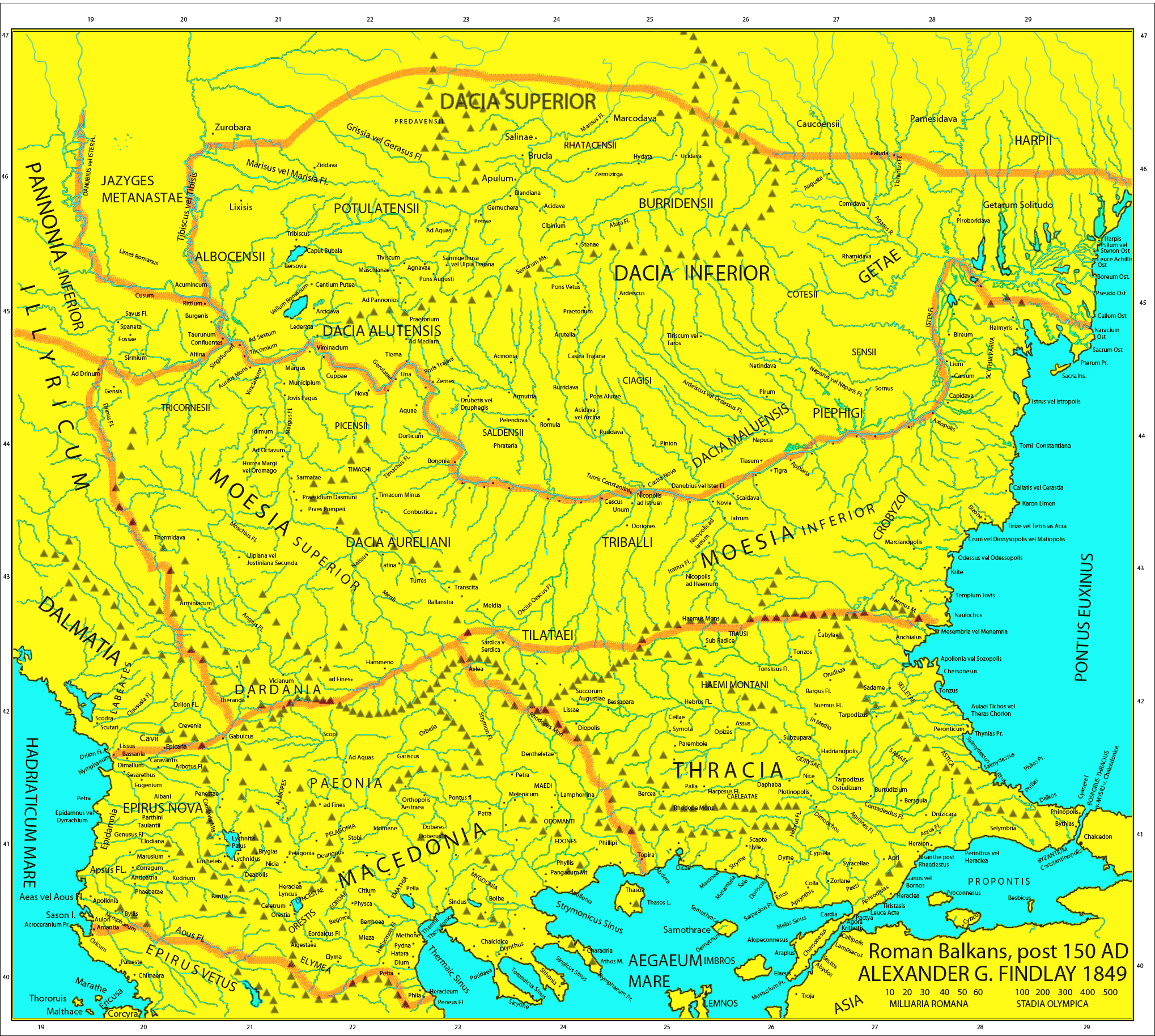
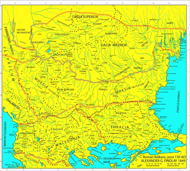
Map of the Roman provinces of Macedonia, Thracia, Illyricum, part of Pannonia Inferior, Moesia & Dacia. It is a reproduction of the 1849 Finley Map with Roman provincial borders (of about 150 AD) added to provide more information. This means that locations of many cities, tribes or other features are according to 1849 scholarship and not up to date. For example, many cities shown have not been identified yet and Findlay made arbirtrary conclusions. A great omission is that Lake Prespas are missing.
|
||
| Date | |||
| Source |
A classical atlas, to illustrate ancient geography: comprised in twenty-five maps, showing the various divisions of the world as known to the ancients : composed from the most authentic sources with an index of the ancient and modern names,Alexander G. Findlay,Publisher;Harper,1849 (Macedonia, Thracia, Illyria, Moesia, Dacia),Map X,"Comment on Map from author; Map X., & c. - Although most portions of this map are well represented, still we have a deficiency in the classical portion, as it has not been yet sufficiently examined by those who are capable of deciding and systematizing the comparative geography."
|
||
| Author | User:Megistias | ||
| Permission (Reusing this file) |
|
||
| Other versions |
   |
File history
Click on a date/time to view the file as it appeared at that time.
| Date/Time | Thumbnail | Dimensions | User | Comment | |
|---|---|---|---|---|---|
| current | 15:44, 5 May 2019 | | 2,038 × 1,828 (2 MB) | Julieta39 (talk | contribs) | Regiones Porolissensis et Napocaoensis cum salinae et aurum excavationes |
| 14:05, 24 September 2017 |  | 2,038 × 1,677 (1.9 MB) | Julieta39 (talk | contribs) | Orthographic correction (alutensis, not alupensis and superior, not superirior) | |
| 20:04, 5 November 2015 |  | 2,038 × 1,677 (1.9 MB) | Spiridon Ion Cepleanu (talk | contribs) | Easier colours for reading the place names | |
| 17:30, 25 February 2010 |  | 2,038 × 1,677 (1.8 MB) | Megistias (talk | contribs) | == {{int:filedesc}} == {{Information |Description=Map of the Roman provinces of Macedonia, Thracia, Illyricum, part of Pannonia Inferior, Moesia & Dacia. It is a reproduction of the 1849 Finley Map with Roman provincial borders (of about 150 AD) added to |
You cannot overwrite this file.
File usage on Commons
The following 20 pages use this file:
- Ancient Thrace and ancient Thracians
- Atlas of Albania
- Atlas of Bulgaria
- Atlas of European history
- Atlas of Romania
- Atlas of Transylvania
- Atlas of ancient Rome
- Atlas of the antiquity
- Dacia and Dacians
- Illyria and Illyrians
- Komotini
- User:J budissin/Uploads/BiH/2017 September 21-30
- User:J budissin/Uploads/BiH/2019 May 1-10
- User talk:Jkransen
- User talk:Megistias
- File:Macedonia-Thracia-Illyria-Moesia-Dacia1849.jpg
- File:Macedonia-Thracia-Illyria-Moesia-Dacia1849refurbished.jpg
- File:Post Roman Balkans.jpg
- File:Roman Empire Map 150 AD Dardania by Alexander Findlay.png
- File:Roman Empire Map 150 AD Epirus Nova or Illyria Graeca by Alexander Findlay.png
File usage on other wikis
The following other wikis use this file:
- Usage on el.wikipedia.org
- Usage on en.wikipedia.org
- Usage on fr.wikipedia.org
- Usage on la.wikipedia.org
- Usage on nl.wikipedia.org
- Usage on pt.wikipedia.org
- Usage on ro.wikipedia.org
- Usage on uk.wikipedia.org

Recent Comments